
In recent years, surveyors have more and more often turned to drone-supported lidar to complete large surveying projects, taking advantage of the technology to more quickly and accurately survey sizable and complex terrains. According to a report from Fortune Business Insights, the market for lidar drones was $129 million in 2020, and is projected to grow to $143 million this year and up to $455 million by 2028, a compound annual growth rate (CAGR) of nearly 18 percent. Companies are surely looking to take advantage of this growth by expanding their solutions, including YellowScan, who recently announced Voyager, their long-range drone lidar solution.
Just this month, a new partnership was announced to provide end-to-end support for these projects, with SPH Engineering and their flight planning UgCS software being integrated with GreenValley International’s data processing LiDAR360 platform.
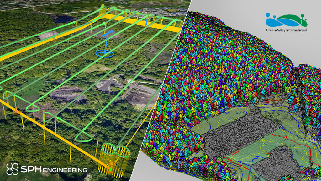
This could be a very big deal for users who are looking for end-to-end software to support their large-scale drone surveying projects. With UgCS, users are able to pre-plan their flights in the software to ensure the entire area they want covered will be scanned. There are a multitude of different flight patterns that can be planned, both for photogrammetry flights and lidar, with features assisting with both traditional and vertical scans. The software, which also includes live flight video, is compatible with nearly every popular lidar platform as well, including brands like YellowScan, DJI, RIEGL, and more.
Meanwhile, once that flight is complete, users can then turn to GreenValley’s LiDAR360 platform to process the captured data. With the framework, users can effectively interact with and manipulate lidar point cloud data – over 300 gigabytes of lidar data simultaneously – pursuant to their needs, with the software also including data management, automatic strip alignment, and point cloud classification, which includes over 10 peer-reviewed algorithms to ensure maximum accuracy.
This new partnership should provide plenty of use cases for surveyors between the two products. The LiDAR360 Framework has a few different specific applications, including for forestry, mining, powerline, utilities, and terrain. Combined with the many customization possibilities for flight planning with UgCS, including the aforementioned vertical as well as both corridor – particularly useful in combination with LiDAR360’s Powerline application – and area with the ability to pre-plan U-turns and loop turns in the flight.
SPH Engineering was founded in 2013 and is based in Latvia, but now has a global customer and network base that spans over 150 countries around the world. A provider of UAV software solutions and integration services, the company’s main business lines are the aforementioned UgCS, UgCS Integrated Systems with sensors from a number of different manufacturers, Drone Show Software, and a consulting and development business line.
GreenValley International has a widespread business model and is based in Berkeley, California. Founded in 2013, they provide both hardware and software solutions for surveyors and self-describe as building “turnkey solutions for forestry, topographic surveying, emergency response, autonomous driving, and vegetation management for electric utilities, as well as many other sectors and industries.” In addition to the data processing software, they have a number of hardware systems, with options for both aerial and ground-based scanning.
As the popularity and usage of drone-based lidar scanning becomes even more commonplace in the industry, users are going to continue to seek out more end-to-end solutions. This partnership between SPH and GreenValley looks to be getting in on this trend.


