

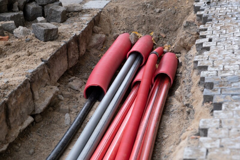
When talking to people in the AEC industry, one of the most striking realities that often comes to light is just how little we know about what is happening under the Earth’s surface. This isn’t commentary about deep underground within the Earth’s core, or really anything natural under the ground. Despite relying on massive amounts of infrastructure of various uses and ages, our knowledge as to exactly where these assets are located is relatively sparse. This is because a lot of these assets were buried long before the digital age, meaning we have to rely on old paper records that were often based on plans rather than where pipes and wires were actually located.
This has always been a problem that had potential to pose real threats to both workers and surrounding communities, as unintentional strikes can lead to massive water or gas leaks, or worse. Secondarily to the human danger, but still a major problem, is the timing and cost effects this can have on projects. And with urbanization continuing to trend up, more infrastructure will have to be put underground, leading to more potential strikes.
As such, underground surveying is a fast-growing space as various technologies and strategies can be used to present a better idea of what exactly is happening under the surface. Below is a look at some stories from Geo Week News covering this rapidly evolving space, including broad looks at the problem as well as some tools and companies looking to address these problems.
Revealing What's Underground
We start with an article that’s almost two years old now, but it still contains relevant information and is a good starting point for understanding this problem. The article looks at some statistics highlighting the danger posed by a lack of knowledge around underground infrastructure, and the ways that technologies like laser scanning and digital twins can help mitigate some of the potential dangers. There have been plenty more developments in the space since this article was written in the summer of 2022, but many of the underlying issues still exist today.
GeoCal is helping to map assets under the ground
For this article, we look at a specific company whose goal is to provide more accurate locations of subterranean infrastructure. GeoCal is a part of EnviroCal and specializes in providing 3D maps of utilities under the ground. The company uses gyroscopic devices which can be placed directly in pipes with various ways to be pulled or pushed through, collecting accurate location data the entire way through. While this isn’t the kind of technology that can necessarily provide maps of assets prior to digging, the data they collect will be extremely valuable moving forward as they ensure asset owners will have highly accurate data regarding their pipes’ locations.

Hexagon's industry trends for surveying in 2024
This article from the end of 2023 isn’t entirely focused on this issue, but it does come up in the conversation. In December, Geo Week News spoke with Leica Geosystems’ Craig Hill about some of the trends in the surveying industry he expected to see in the coming year. One of the big themes of the conversation was his opinion that surveyors who wanted to compete in a growing market would need to diversify their services, and one of the ways to do so was around detection of underground utilities. You can read the full conversation with the link below, but one of the ideas he had was for a “Safety-as-a-service” offering that included this detection of subterranean assets.
Combining Multi-Sensing Scanning and Artificial Intelligence for Underground Detection
This is another article from 2022, with this one looking at a company that at the time was one of the newest in this field and has since become among the biggest players. Exodigo is based in Israel and now has offices in the United States, and they utilize a multi-sensing approach to collect a variety of data which is then pushed through a proprietary algorithm to produce an accurate map of the underground. The article details the way this technology has been used not only for asset detection, but also things like predicting sinkhole risk for an area.
Reveal launches new Underdots data-as-a-service product
Here we have another look at a company offering for more complete underground information, but this time on the software side. Reveal announced the launch of their data-as-a-service product, Underdogs, late last year which they claim “massively speeds up the analysis of utility locating data.” The online service creates point cloud visualization from ground penetrating radar at significantly quicker speeds than had previously been the industry norm.
Understanding flood behavior with underground lidar data
Most of the focus for the other articles listed here has been around infrastructure and other assets under the ground, but collecting data about this space can also play a role for other use cases, including preparation for coastal flooding. This article looks at the way SLAM-based lidar scanning is being used to map underground spaces in Belfast, Northern Ireland in order to have a more complete picture of the underground terrain and how the city could be impacted by potential flood scenarios.


