

Sponsored by GeoCal
According to a United Nations assessment, over half of the world's population now resides in urban areas, up from around one-third in 1950. By 2050, it is expected that this percentage will approach two-thirds of the global population. As a result, the higher concentration of inhabitants in urban areas puts strain on the infrastructure. Infrastructure failures in a densely populated area have larger, more immediate, consequences. A water main break now occurs in the U.S. every two minutes, and an estimated six million gallons of treated water are lost each day.
Furthermore, the importance of aging infrastructure has taken center stage. Recent legislation has poured billions of dollars into replacing aging infrastructure. The Bipartisan Infrastructure Law invests over $300 billion in repairing and rebuilding America's roads and bridges.
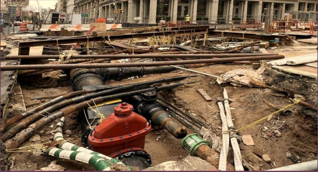
What these two trends and the resulting construction booms have in common is that they each require a lot of work involving digging underground. Much of the aging infrastructure of concern in the United States is under the surface, and new infrastructure needs to be placed to accommodate growing urban populations. This isn’t a bad thing, but as we’ve talked about before here at Geo Week News construction involving digging can be dangerous given our relative lack of knowledge of what’s happening below the surface.
Unfortunately, while all of this underground construction continues, the underlying issues leading to dangerous and costly utility strikes have not been resolved. According to the Common Ground Alliance, a nonprofit focused on preventing damage to underground infrastructure, reported nearly a quarter million incidents taking place on an annual basis, with damages in the United States costing an estimated $30 billion per year. Between those astronomical costs and the safety concerns that come when assets like gas lines or water mains are struck, this is a problem that needs to be solved as construction only figures to keep growing.
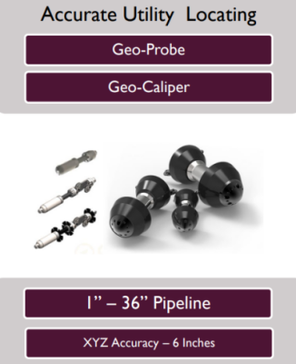
There is no silver bullet technology that can be used to accurately detect all existing underground infrastructure, including traditional surveying techniques, ground-penetrating radar (GPR), and walkover beacon systems. In the ever-evolving utility management and infrastructure maintenance, innovation plays a pivotal role in ensuring efficiency, reliability, and sustainability. The new approach of Inertial measuring unit or IMU is an additional tool into the contractor’s tool kit to provide precise spatial position of any UG utility.
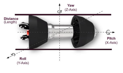
GeoCal is a business sector of EnviroCal specializes in 3D utility mapping services and operates using cutting-edge technology. It is approaching the problem in a novel way by using IMU mapping technologies to accurately map existing pipelines of different sizes and materials in spatial space (XY & Z-Depth). Gyromapping is operated inline to the pipe measuring the angular rate of change of position every second, collecting 1000Hz samples per second. With known entrance & exit GIS coordinate will enable to software to generate accurate plan & profile with GIS XYZ-coordinates every foot, creating an accurate as-built map.
All utilities must comply with regulatory requirements from local, state, and federal agencies. Gyroscopic mapping aids in compliance by ensuring accurate records and supporting the documentation needed for audits and reporting. The IMU then provides accurate X, Y, Z data throughout the pipeline to give an accurate representation of where this asset lives underground which can be given to future construction firms who may need to dig in the area.
Depending on whatever path makes the most sense for that specific application, there are four possible methods to send the tool through the pipeline to collect the data. For instance, primarily in fiber and telecom ducts the probe is pulled using a winch, for electric conduits the tool is pushed using fiberglass rod with pusher mechanism, for oil & gas pipelines the probe operates in pressurized conditions travelling along the flow of medium, finally for Sanitary sewer pipelines the tool is integrated into a motorized crawler system to travel collecting the data and obtain a precise as-built map.
One thing that becomes clear in conversations with the GeoCal team is that there is recognition that their system is not the only viable solution towards solving this problem. For certain applications, the technologies mentioned above can certainly still work. However, their IMU-based tool does provide a number of advantages. For one thing, it works for pipelines of any material, metallic or non-metallic, and any kind of underground utility. It can also be used for assets of any depth, something that can’t be said of technology like GPR whose work takes place above the surface.
In addition to all of that, perhaps most important is that GeoCal’s tool is largely non-intrusive. It doesn’t require the above ground tracing ability that other techniques do, nor does it expel electromagnetic signals leading to traffic disruptions. It’s not adherent to satellite reception, meaning it can still work within a congested urban area surrounded by skyscrapers, and it does not have any impact on local soil conditions.
The CGA indicates that, of all of the underground strikes captured in the statistics noted above, over a third are the result of locating practices. Unfortunately, we are still relying on old as-planned maps for much of our underground infrastructure, particularly in older cities, which leads to poor knowledge of where these pipelines are actually located under the surface. It’s crucial to have this information in an accurate and accessible format, and that’s GeoCal’s mission. Working with utility owners, they provide accurate, three-dimensional data which can be processed into CAD software and will be on-hand to pass off to any other asset owner who may need to dig in that area. With all of the construction expected over the next few decades, improving our knowledge of the underground is an absolute must.
Meet GeoCal at Booth # 339, and also attend the seminar on GIS Mapping is Key for Future Damage Prevention | Case Study: How DOTs Took a Proactive Approach. For further inquiries, contact Santosh Saride, Vice President of Strategy & Business Development with GeoCal, at [email protected].


