“This is almost like day one for the new geomatics business,” a company representative said.
After several years focusing primarily on construction and agriculture, Topcon Positioning Systems is refocusing attention on its geomatics roots. At INTERGEO 2025, the company announced a major strategic shift: the creation of a dedicated global business division for geospatial applications, alongside an expanded portfolio of hardware and software designed to streamline workflows, improve data quality, and enhance visualization.
This renewed focus signals Topcon’s commitment to delivering high-precision solutions specifically tailored for the surveying, mapping, and reality capture markets.
A Strategic Refocus
Topcon’s decision marks a pivotal change in how the company organizes its technology portfolio. Previously, Topcon’s business was structured around two major areas: precision agriculture and construction. The latter included most of Topcon’s data capture technologies, though these often remained siloed or overshadowed by other construction-focused innovations.
Now, with the establishment of a third business segment devoted solely to surveying, GIS, and reality capture, Topcon aims to consolidate and expand its geospatial offerings while opening new pathways into emerging markets that rely on spatial intelligence.
The reorganization follows the appointment of Ivan di Federico as Topcon’s new president and CEO after the retirement of long-time leader Ray O’Connor. In a press release announcing the move, Di Federico described geomatics as entering “a new era.”
“Today, it is about capturing massive amounts of geospatial data, connecting multiple data streams, and delivering insight with the speed and simplicity our customers demand. Topcon’s role is to reduce the gap between field capture and business decisions. By elevating geomatics into its own global business group, we are signaling that this discipline is vital — not just for traditional professionals, but for every sector where spatial intelligence drives efficiency and growth.”
Expanding and Democratizing Data Capture
Topcon’s expanded geomatics portfolio introduces a range of new products designed to make high-quality data capture more accessible. The goal is to support not only professional surveyors but also technicians, project managers, and supervisors who need quick, accurate site information.
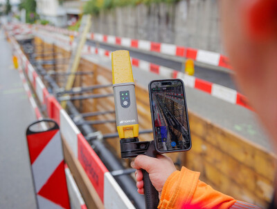
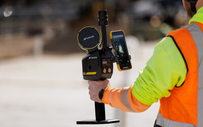
Among the highlights is the CR-H1, a handheld reality capture device developed in collaboration with Pix4D. The system integrates an iPhone Pro’s lidar capabilities with photogrammetry to create full-color 3D scans. When paired with Topcon’s HiPer CR receiver, it enables RTK accuracy via the Topnet Live GNSS correction service. The lightweight handle-mounted setup is designed for rapid field documentation, particularly for applications such as capturing utility trenches or construction progress.
Notably, Pix4D’s use of Gaussian Splats allows for more realistic visualization and faster rendering than traditional point clouds. This feature is especially beneficial for utility and infrastructure mapping, where users may not have advanced geospatial training but still need precise visual context.
New Entrants to Mobile and Handheld Scanning
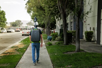
Topcon is also making its first entry into the mobile mapping market with the CR-M1, a lidar-camera system that can be mounted on a backpack or survey pole and offers a range of up to 100 meters.
For handheld scanning, the CR-S2 employs fusion-SLAM localization to handle mapping projects in complex or GPS-limited environments. Designed for construction and infrastructure applications, it can also operate effectively in open or featureless settings such as coastlines, airports, or farmland, where RTK positioning via Topnet Live ensures accuracy.
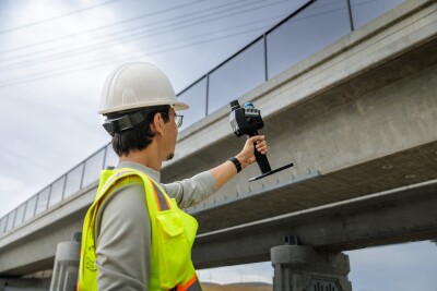
Collected data can be easily uploaded to Collage Web, Topcon’s browser-based visualization platform, allowing users to view, measure, and annotate 3D point clouds and meshes without specialized software.
For conventional terrestrial scanning workflows, Topcon introduced the CR-P1, a multi-functional 3D terrestrial laser scanner developed in collaboration with Faro. The CR-P1 delivers real-time, georeferenced point clouds in the field, providing immediate insight for surveying, infrastructure, and reality capture applications.
Looking Ahead
Topcon showcased its new geomatics division and product portfolio at INTERGEO 2025, where initial reception from customers and partners has been “very positive.” The company views the event as the beginning of a long-term strategy to unify its geospatial ecosystem. The focus will be on connecting devices, data, and decision-making tools under a single, customer-centered framework, says Nathan Ward, Business Development Manager, Utility Solutions.
“Our goal is to make technology that not only captures the world more efficiently, but also empowers our customers to make better decisions faster.”
With a renewed focus on geomatics, Topcon is staking a clear claim in the evolving landscape of geospatial intelligence, bridging traditional surveying with the next generation of data-driven insight.