
Despite the construction industry’s reputation for being relative laggards in technological adoption, there’s little doubt from those in the space around the value tools enabling 3D visualization can provide on a job site. One of the big issues in really taking the leap for many firms has been the wide range of available tools to complete a project, and recognizing which will provide the most value for any given job. While some may be best served using a high-accuracy terrestrial scanner, others can be best utilized with a mobile mapping solution, or even a handheld scanner to walk through a site. And that’s just for things above the ground. To help kill two birds with one stone, so to speak, Tesmec has recently announced a new hybrid data capturing mechanism to simultaneously collect information about things happening under the surface and above it, with their new Mobile Mapping System.
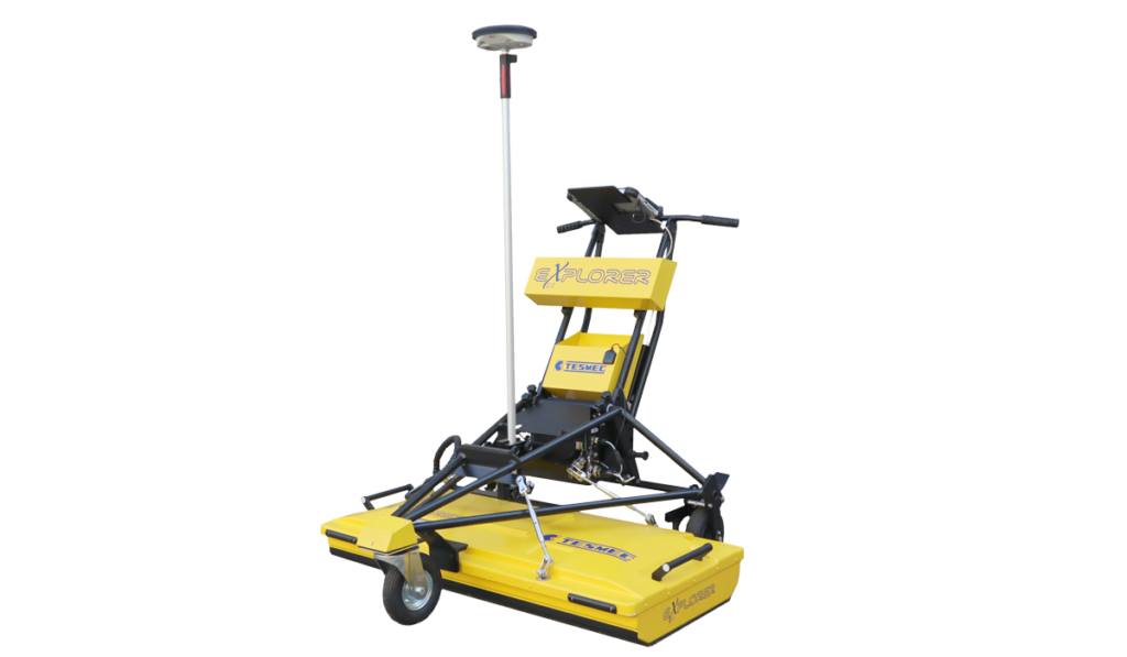
The company’s Mobile Mapping System, announced at Bauma 2022, is a lidar scanner that is designed to be placed atop their Georadar Explorer 2.0, a ground probing radar system. With this attachment on the top of the radar system, users are able to detect underground utilities using the ground probing radar while simultaneously capturing high-precision digital 3D surveys of the environment above the ground. Through a mix of 3D point cloud data obtained through the lidar technology as well as 3D point cloud data obtained through stereoscopy algorithms applied to the images acquired by high resolution matrix cameras, users are able to come away with a georeferenced 3D reconstruction of a site, with an artificial intelligence network processing the data to produce the resulting point cloud.
Tesmec’s new mobile mapping system boasts an accuracy of around 2 centimeters, and the point cloud derived from the system can be transferred to a cloud platform to be used in the planning of a construction site. Attached to the Explorer 2.0, the entire system can work when attached to the back of a vehicle, working at speeds up to 17 km/hr (about 10.5 mph). Additionally, the radar can scan the ground up to a depth of 96 centimeters, and all of the data can then be uploaded to the cloud and superimposed on the as-built map generated by Tesmec’s SmartTracker.
This kind of integration of two different surveying methods could be a big time-saver for a variety of industries and project types, especially those involving digging in an urban area. We know that an incomplete knowledge of what assets lie where under the surface can lead to unsafe conditions for workers and the surrounding communities, as well as expensive delays and repairs, and the Explorer 2.0’s radar system helps detect that. Being able to capture that information while also creating 3D visualizations for the project’s status to that point above the surface saves time to be spent completing other crucial functions on the job site. Particularly given the hiring shortages happening around the construction industry right now, any time that can be better allocated for those on the ground is going to be welcome by the entire team.
Tesmec is an Italian-based company specializing in the design, manufacturing, and sales of solutions for the construction, maintenance, and efficiency of infrastructure. In addition to this data capture technology , the company also produces rock trenching equipment, surface miners, stringing equipment, rail equipment, and devices for smart grid management.
On the company’s new mobile mapping solution, New Technology Manager at Tesmec Marco Quarta said, “The Mobile Mapping System is a solution that can be combined with excavation technology and is complementary to it. The digital transformation has naturally pushed us towards the creation of a new portfolio of technologies and business models. This is a further step towards the supply of integrated solutions for the underground laying of high-tech cables. The product is part of the group’s growth strategy, under the banner of digitalisation, sustainability and energy transition, with the aim to bring the advanced image processing and artificial intelligence skills acquired by the group in different verticals to markets that are still unexplored.”


