

The June 24, 2026, earthquakes in Venezuela did more than shake buildings and send seismic waves across the country. According to a preliminary analysis by geodesists at my alma mater, Universidad Central de Venezuela (UCV) and the Instituto Geográfico de Venezuela Simón Bolívar (IGVSB), which is the official mapping agency of the country, the event produced a measurable and permanent shift in the position of part of the country’s geodetic network.
The most striking result was in Caracas, where high-rate GNSS observations indicate that a continuously monitored station moved approximately 47 centimeters, nearly half a meter, (1.5 ft) as a result of the earthquake. The calculated displacement was predominantly east-west and was directed toward the northwest, broadly consistent with movement associated with Venezuela’s San Sebastián fault system. The finding represents one of the clearest demonstrations to date of Venezuela’s ability to use GNSS technology to measure earthquake-induced deformation directly.
The report, prepared by the UCV Department of Geodetic Engineering and Surveying in collaboration with the IGVSB, was issued in July as a preliminary technical assessment. The researchers emphasize that it was produced rapidly in response to an extraordinary event and should therefore be regarded as an initial scientific evaluation rather than a final geological interpretation.
Venezuela occupies a highly active tectonic environment created by the interaction of the Caribbean and South American plates. According to the report, the principal boundary between the plates lies north of the country and includes the Boconó, San Sebastián and El Pilar fault systems. These zones accommodate deformation between the plates and are responsible for much of the region’s seismic activity. The USGS in the USA has dedicated a considerable amount of time and resources to analyze these events since they occurred (https://www.usgs.gov/data/remote-observations-surface-deformation-m72-and-m75-2026-venezuela-earthquakes).
The June 24 event was reported by several seismic agencies, with the epicentral locations generally placing it near San Felipe in Yaracuy State. To investigate its geodetic effects, the UCV processing center analyzed high-rate GNSS observations from three stations, COR1, BARQ and CCS1, forming a triangle around the event. The objective was not only to detect permanent changes in position, but also to capture the arrival of the earthquake’s seismic waves.
The researchers used two complementary GNSS datasets. One-second observations were processed using kinematic Precise Point Positioning (PPP) techniques to identify the P- and S-wave arrivals and calculate position, velocity and acceleration. Thirty-second observations were processed using static PPP solutions from the day before and the day after the earthquake. Comparing those positions allowed the team to calculate topocentric displacement vectors and distinguish permanent co-seismic movements from the temporary motion caused by passing seismic waves.
The results varied significantly from station to station.
At COR1, the researchers found no evidence of permanent co-seismic movement. The station’s position record exhibited oscillations consistent with an antenna mounted on a building, but there was no change in the underlying trend that could be associated with a permanent earthquake displacement. The velocity record likewise showed no significant variation associated with the event.
BARQ recorded a much more obvious response to the passing seismic waves. At the arrival of the S wave, its position changed by approximately four centimeters east-west, 4.8 centimeters north-south and 11 centimeters vertically. But the station subsequently returned to its previous trend. The UCV team therefore interpreted these changes as transient seismic motion rather than permanent co-seismic displacement.
CCS1 was different. Its high-rate GNSS record showed instantaneous variations of approximately 0.519 meters east-west, 0.91 meters north-south and 0.43 meters vertically during the event. The north-south and vertical components subsequently recovered their previous trends, but the east-west component did not. The researchers identify approximately 0.401 meters of permanent east-west co-seismic displacement in the position record.

A second analysis provides an even more significant measurement. By comparing static PPP solutions from before and after the earthquake, the researchers calculated a topocentric vector of −0.470 meters for CCS1. The corresponding result for nearby station INTU was −0.446 meters. The report translates those results into preliminary total displacements of approximately 0.47 meters at CCS1 and 0.45 meters at INTU.
The INTU observation is particularly important. Located only 3.39 kilometers (2.1 miles) from CCS1, the station was examined specifically to determine whether the large displacement recorded at CCS1 could have been caused by the structure supporting the antenna rather than by actual ground movement. INTU showed the same general east-west displacement trend, with approximately 0.419 meters of co-seismic movement. That independent observation strengthens the case that the approximately half-meter shift represents genuine geodetic displacement rather than an artifact of the CCS1 installation.
The GNSS network also captured the earthquake’s seismic signature. At CCS1, the researchers identified the arrival of the P wave at approximately 22:05:00 UTC and the S wave roughly 30 seconds later. From the acceleration record, they estimate the principal event duration at approximately 34 seconds. The data also show a pronounced north-south oscillation that the researchers associate with a wave arriving from the north.
That observation raises an intriguing question about the earthquake itself. GFZ GEOFON (https://geofon.gfz.de/) reported another event or seismic source north of La Guaira. The CCS1 record contains a northward peak that could be associated with that reported source. However, the UCV researchers caution that it is too early to determine whether this represents a separate earthquake or the centroid of the same event. They note that GlobalCMT (https://www.globalcmt.org/) places the earthquake centroid close to the second reported location.
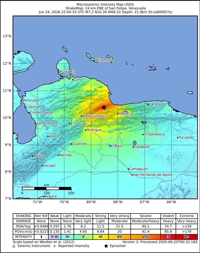
For now, the UCV–IGVSB team favors a single-event interpretation. Its seismic-geodetic evidence indicates that the earthquake’s waves traveled along the rupture zone toward the La Guaira coast. The researchers emphasize that additional geological analysis will be necessary to resolve the remaining questions about the event’s rupture geometry and seismic source.
Perhaps the broader significance of the report lies not only in the earthquake itself, but in what the GNSS measurements demonstrate. A network originally designed to provide stable geographic reference positions has effectively become a high-resolution sensor for the movement of the Earth’s crust. In this case, it detected the passage of seismic waves, distinguished temporary motion from permanent deformation and measured a nearly half-meter change in the position of a station in Caracas.
The authors describe the study as the first evidence of a seismic-geodetic evaluation in Venezuela using high-rate GNSS data.
That makes the June 24 earthquake more than a seismic event. It is also a demonstration of the value of a modern geodetic infrastructure, and of how precisely GNSS can reveal what happens to the ground when a major earthquake passes through it. Perhaps we are at the birth of a permanent fusion of GNSS CORS stations around the world and seismic research.


