Contributed by CHC Navigation
For more than two decades, Global Navigation Satellite System (GNSS) technology has been the backbone of the geospatial industry. It has fundamentally reshaped how we capture, measure, and understand our world. In the early days, the promise of a GNSS receiver was straightforward: provide centimeter-level accuracy for positioning, as long as you had a clear, unobstructed view of the sky.
This was more than enough for rural topography, agricultural applications, and projects in wide-open spaces. But the moment a surveyor stepped onto a city street, into a dense forest, or beneath the shadow of infrastructure, the reliability of GNSS would begin to waver. Multipath interference, signal blockages, and a reduced satellite count led to position jumps, frequent loss of a fixed solution, and a frustrating drop in productivity. Surveyors learned to adapt, but every workaround—whether it meant re-surveying a point or switching to a different instrument—added cost, complexity, and lost time to the project.
The Rise of the Hybrid: Why GNSS Couldn't Go It Alone
The industry’s initial response was logical: if satellite signals are the single point of failure, let's add more sensors to compensate. This marked the birth of the hybrid GNSS receiver.
The first major leap forward was the integration of Inertial Measurement Units (IMUs). This was a milestone advancement that freed surveyors from the tedious task of meticulously leveling the survey pole before every measurement. IMU-based tilt compensation enabled fast, accurate measurements at an angle, dramatically speeding up fieldwork and enhancing stability in challenging environments by helping to filter out erratic GNSS data.
Next, we saw the addition of cameras and laser distance meters. These were designed to solve the problem of inaccessible points. Why risk climbing a stockpile or wading through a ditch when you could aim a laser or snap a photo from a safe distance? While these integrations were valuable, they largely functioned as bolt-on modules to enhance remote measurement, rather than being deeply fused with the GNSS system to improve efficiency and safety across more scenarios. Photogrammetry-based methods required time-consuming processing, while laser aiming demanded a steady hand.
The Next Leap: Multi-Sensor Intelligence
Today, the trajectory is clear: more sensors, more intelligence, and deeper integration. Advances in lidar, computer vision, and high-efficiency processors mean that positioning hardware can now interpret its surroundings in real time, not just after the fact.
A new generation of hybrid GNSS receivers is emerging — devices that can:
- Fill in position gaps seamlessly when satellite reception is interrupted.
- Detect and reject corrupted signals caused by multipath reflections.
- Enrich geospatial datasets with visual and spatial context.
- Deliver ready-to-use results on-site without waiting for office processing.
This isn’t about survival in challenging environments. It’s about thriving in them.
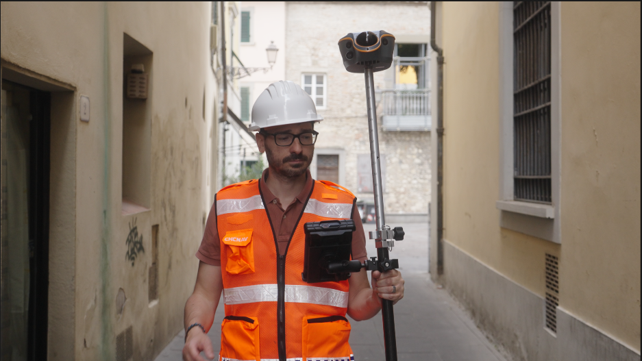
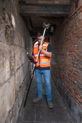
A Glimpse Into the Future: ViLi i100 Visual-LiDAR GNSS Receiver
The ViLi i100 fuses GNSS, a high-frequency IMU, a high-density lidar scanner, and multiple cameras into a single unified data engine, where powerful algorithms treat every input not as separate tools, but as parts of one coherent truth.
In real time, the receiver analyses incoming satellite signals, automatically detecting and filtering those compromised by multipath interference. The result is a smooth, jump-free position stream with consistent 5 cm absolute accuracy — dependable in every fix.
But what happens when GNSS signals disappear completely? This is where the ViLi i100 truly redefines what’s possible. Powered by our next-generation SFix 2.0 engine, the receiver leverages its high-density lidar, capturing 860,000 points per second, to build a dynamic 3D model of its surroundings. Using its last trusted GNSS position as an anchor, advanced positioning algorithms then reconstruct the receiver’s precise location based on its relationship to the surrounding environment. This allows surveyors to continue working with reliable 5 cm accuracy for up to 20 meters into a GNSS-denied area—under a bridge, inside a short tunnel, or deep within an urban canyon. It delivers a true "GNSS everywhere" experience, eliminating the need to switch to a total station.
Beyond Hardware: Building Trust in Every Measurement
The coming years will belong to solutions that prioritize advanced algorithms, intuitive workflows, and a deep understanding of user needs. Hardware will continue to evolve at a rapid pace, but true trust in a surveying tool is earned when it performs flawlessly, no matter the conditions.
The hybrid GNSS receiver’s journey — from open-sky dependency to intelligent, multi-sensor resilience — is not just a story of technology. It’s the story of giving surveyors the confidence that every point, every line, and every dataset they collect will stand up to the demands of the real world.
Want to see how ViLi i100 performs in your workflows?
Meet us at Geo Week 2026, Booth 1723!
Hands-on DEMO of the ViLi i100 Visual-LiDAR GNSS Receiver in the Demonstration Zone:
Feb 17 | 10:00 AM – 10:30 AM & 5:00 PM – 5:30 PM