

Sponsored by JP Global Digital
In this age of rapid technological development, much of the focus is on innovative new products being created on a daily basis. Competition drives better products at a cheaper price point - a phenomenon we recently wrote about in the reality capture space. The article focused on the cost and accessibility of the hardware needed to capture spaces, but there is also the very important piece around the software needed to process and interpret it, turning it into insightful and actionable data.
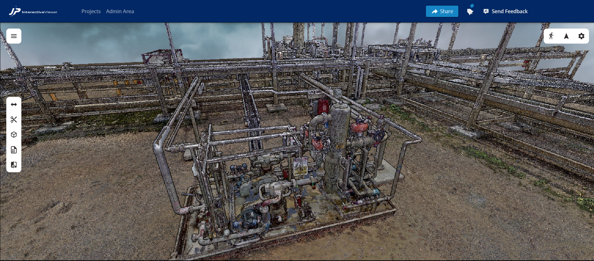
Alongside cost improvement, there are also industry tailwinds that are improving the value of this data. Improving accessibility makes it easier to solve problems with this data, and the more problems solved, the higher the ROI. JP Global Digital’s JP Interactive Viewer (JPIV) is a perfect example of providing the necessary software to get the most out of the increasingly affordable and usable hardware.
The Data Has Been Captured. Now what?
At this point, it’s broadly agreed upon that having this reality capture data is a big boon for a wide variety of industries to get accurate and up-to-date information on a given project. And now that it’s becoming easier to collect that data, it’s being put in the hands of more and more asset owners, project managers, and other key stakeholders. Unfortunately, it’s still a different story when it comes to acting upon the data. There are all sorts of barriers preventing owners and managers from making the most of this data – it’s often decentralized and siloed, it’s a tedious and/or arduous and costly process to share and ensure the right people are receiving the right information, it’s an overly technical process for which few, if any, team members are trained – which in turn makes it hard to get an ROI from that data collection. And, of course, that is the whole point of collecting it in the first place.
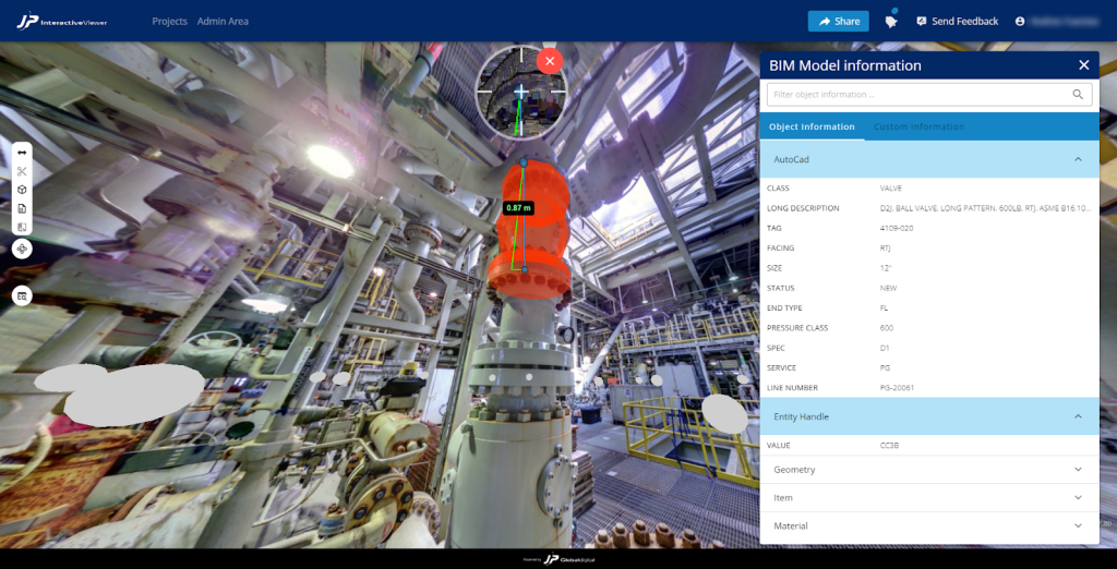
That’s where platforms like JPIV come in, as the web-based software solution works to counter all of those barriers to ensure their customers are able to get the ROI they seek from their collected data. For starters, the platform puts all of a user’s collected 3D data, from all different sources, into one singular location, taking away the often tedious and time-consuming process of searching different platforms for all pertinent information. They also make it easy for users to share customized information for different stakeholders, creating an easy way to simply share links across a project. This ensures that the right people are getting all of the information they need – and nothing more – as quickly as possible to prevent costly delays and confusion. And on top of all that, JPIV is made to be user-friendly, allowing it to be easily used by even non-technical workers. It’s even available to be utilized on a tablet, allowing those on-site to have quick access to crucial data when they need it.
Turning data into solutions
As many enterprise industries look to streamline their workflows to cut down on budget overtures and costly delays to their projects, they are looking to better collaboration as a major key to reaching that place. Ensuring real-time collaboration of accurate, up-to-date information across all stakeholders means that potential clashes in design will be caught earlier and resulting delays can be cut back significantly. This is one of the areas in which JPIV excels, providing the data to everyone who can benefit.
That group of stakeholders who can benefit from this reality capture data is larger than many may think, too. Of course, project managers and asset owners certainly have plenty to gain, having a clear picture of work that has been completed to this point as well as other areas that will need to be addressed. It also allows them to perform remote planning and remote QA/QC when executing a plant turnaround during Capital and O&M projects - a major money and timesaving resource. Those in the field have up-to-date information about what is expected to be done at what point, what has already been completed, and any potential changes to plans or designs.
With a tool like JPIV, model review meetings will no longer be a headache, since it makes it easy and fast to share data with the entire team and expedite the client approval process. On the other side, people in positions like sales and marketing also stand to gain from having easy access to this data to help better drive conversions and host quality demos, while operations staff can use it to perform inspections remotely more efficiently. Those are just a few examples, but with the ability to easily share links to specific models across stakeholders, JPIV can ensure not only that everyone in an organization can access information but that they can actually benefit from it as well.
JPIV In Action
While it’s one thing to hear about all the features and capabilities delivered by JPIV, it’s another to hear it from one of the many customers using the tool to their advantage. Hargrove Engineers and Constructors is a large, multidisciplinary engineering, procurement, construction management firm based in Mobile, Alabama, and a user of JPIV. Adam Driggers, Director of Surveying and Scanning Services at Hargrove, spoke with Geo Week News about his experience using the tool, noting that JPIV has “elevated the way that the team has been able to communicate from our team all the way to the construction folks on site.”
Prior to using JPIV, the sharing of scanning data was an arduous process between teams at Hargrove, and the challenges only built in trying to share visualized data with clients. Driggers notes that most of the issues came from the sheer size of the data being shared, and with the collaboration between teams Hargrove relies upon that meant the most efficient way to share this data was often physically shipping hard drives around to different offices. For clients, they generally didn’t have the hardware capacity to take on the file sizes needed to make the most out of this data, so they had to wait until either they were at the Hargrove offices or a Hargrove team member was on their site to really be able to view the scanning data. Clearly, this was a process that needed adjustment.
JPIV has provided that adjustment, removing the barriers around sharing with their easy-to-share solution. First and foremost, Driggers notes that the tool has enhanced collaboration within the organization and with clients outside. Specifically with those clients, rather than having to wait for a Hargrove team member to share files they are looking for, the shared model within JPIV is just a click away on the cloud. They can find what they are looking for within that model, and if they have any questions they can easily reach out to the Hargrove team to move from there. There’s even the possibility of smaller companies who don’t always have the funding to get accurate scanning data that aren’t part of capital improvement projects. But with a tool like JPIV, Driggers notes that these smaller facilities can create more value for themselves given the ability to not just get a model, but be able to interact with it using the annotation tools and get an easily accessible digital copy of their plant.
At the end of the day, Driggers notes, it’s all about that ease of collaboration, which is no small thing given the massive data files involved with reality capture. With JPIV, “everybody has got access to that one set of truth, that foundational set of reality.”


