
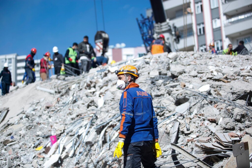
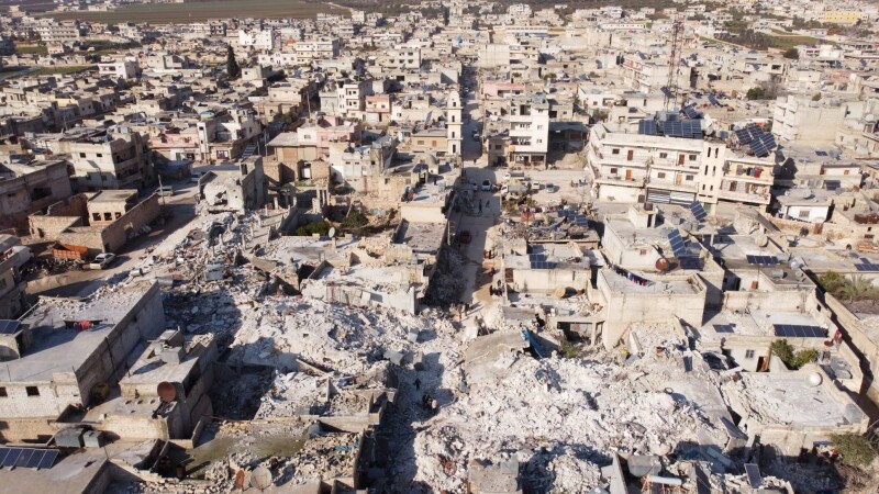
On February 6, 2023, a devastating, 7.8 magnitude earthquake struck the southern and central parts of Turkey and the north and western parts of Syria. It was one of the strongest earthquakes to ever strike the area – a significant fact, given that Turkey is one of the most active earthquake zones in the world – tying for the strongest over the last century and perhaps the second strongest in the nation’s history, trailing only one occurring in the 1600s for which the magnitude can only be estimated. The disaster has tragically resulted in over 50,000 casualties and over 100,000 other injuries.
When events like this take place, citizens of the world come together quickly to try and help in whatever ways they can, realizing that every second counts in the aftermath of this kind of large-scale disaster. We also know from our perspective that accurate location data, GIS and mapping can be a crucial piece to ensuring recovery efforts go as smoothly as possible. One organization jumping into action to address these issues specifically in Turkey and Syria, as well as for many other disasters around the world, is the Humanitarian OpenStreetMap Team (HOT), a global nonprofit organization leveraging the global OpenStreetMap community to provide first responders on the ground with crucial, updated mapping data for an affected area.
Nama Raj Budhathoki is a part of HOT’s leadership team as well as a regional director for the organization’s Asia-Pacific Hub, and he is also the founder of Kathmandu Living Labs. Budhathoki took some time to provide more insight to Geo Week News about HOT’s work.
He explains that the organization was borne out of a similar tragic disaster in Haiti back in 2010, when an earthquake struck the island nation and resulted in over 100,000 casualties. OpenStreetMap, the free and open mapping database maintained by volunteers, had been around for about a half-decade at the time of the 2010 earthquake, but it provided evidence of how important this data can be for a disaster, particularly for countries that are not well mapped like Haiti. The eventual founders of HOT saw the impact mapping made in the recovery efforts for that disaster and aimed to create an organization which fulfilled this role in disasters around the world.
Today, the organization has four hubs, including the Asia Pacific hub for which Budhathoki is director, along with Eastern and Southern Africa, West and Northern Africa, and Latin America. Budhathoki explained that while HOT does work around the world– they refer to their work in times of disaster as “disaster activation” and invite volunteers to map when disaster does strike – they are currently working in 94 “priority” countries which are in need of better and more complete mapping. This is based upon two primary factors, he explains, between the nation’s multidimensional poverty index rating and its risk of disaster.
In terms of how all of this work comes together, Budhathoki explains that it all comes down to the massive and engaged OpenStreetMap community, which as of this writing boasts more than 10 million users. He explains that while HOT does have team members on staff who certainly do plenty of work, they rely heavily on this massive group of volunteers. “There’s no time after a disaster. That means we need more people. We need to get the job done as quickly as possible because every piece of information is so critical. It can make a difference in life and death, and also the sufferings of the people.”
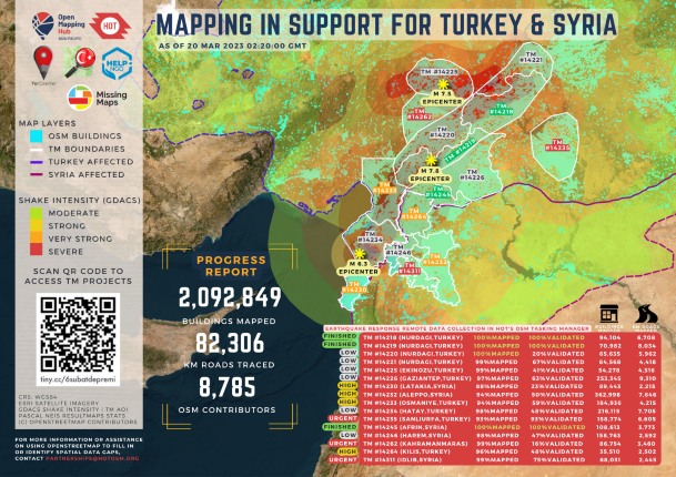
These volunteers do the work remotely from all corners of the world, and use the provided satellite imagery within OpenStreetMap to help identify roads and other key infrastructure, with this information able to be accessed in real time by first responders on the ground to make recovery efforts in the immediate aftermath as smooth and efficient as possible. Budhathoki further explains that after the types of large-scale disasters like the one in Turkey and Syria, you often see universities and other groups organize “mapathons” and similar other mapping events, with over two dozens already taking place for this disaster specifically. All of this work is facilitated through the Task Manager–an online application HOT has developed–which ensures that work is well coordinated among the mappers and that all affected areas are being mapped.
Budhathoki also further explained why this information is so crucial and how it is used on the ground in the aftermath of this kind of disaster. A lot of that revolves around what we talked about above, mapping out roads and showing which are passable and which are not, which is crucial for on-the-ground responders and ambulances transporting victims of a given disaster. He also mentions the importance of keeping track of where displaced people are going. He notes that many people are not able to go back to their homes, or are perhaps frightened in this case given the aftershocks which follow major earthquakes like this one. It’s important for aid groups to know where people are relocating, and how many.
“Remember, when there are hundreds of people quickly getting out of their house and living somewhere, they need water, they need sanitation, they need food, they need medicine. The government and other organizations have to make arrangements pretty quickly, and so it’s very important to know where people are living and how many people are living there.”
In addition to the work done in the immediate aftermath of a disaster, Budhathoki stressed the importance of completing this work before a disaster to ensure areas are as prepared from a GIS perspective for a disaster as possible. This ties back to those 94 priority countries, for which that crucial mapping data is lacking. He said HOT’s “dream is to remain fully prepared in terms of mapping so that when there is a disaster, we’re ready on day one.”
He points to the likely increase of disasters worldwide due to the climate change being a big impetus for needing this preparation work more than ever before. “People get engaged in conduct when there’s a disaster, and they just forget it until there’s another disaster. That’s probably not the best way.”
The good news is, the OpenStreetMap community is a massive one, and going back to the tragic earthquake in Haiti back in 2010 all the way to the one in Turkey and Syria earlier this year, we’ve seen the positive impact it can have.
If you’re interested in getting involved in HOT’s mission, you can learn more here.


