

On Tuesday, NavVis, one of the leaders in wearable mobile mapping technologies, unveiled their next generation of wearable technology, the NavVis VLX 3. This is, as the name implies, the third generation of their wearable VLX system, with the NavVis VLX 2 having been released almost two years ago in July of 2021.
In their release of the news, NavVis points to greater accuracy in their point clouds delivered with the NavVis VLX 3, calling out their two brand new, 32-layer lidars which have been “meticulously designed and crafted” to reduce noise and drift in point clouds while delivering “high detail at range.” The company has also improved their SLAM robustness, which they say makes their newest wearable system “perfectly suited” for projects both indoors and out.
Overall, NavVis says that customers can expect the same reliability and accuracy they experienced with previous generations, with the technology continuing to evolve to “allow customers worldwide to confidently scan, process, and leverage more data, from more sites, for more projects, in less time.”
“We’re thrilled to be launching NavVis VLX 3 today,” says Georg Schroth, CTO and Co-founder at NavVis. “Our team has worked extremely hard to deliver cutting-edge hardware improvements and enhanced scanning features. We’re confident it will exceed our customers’ expectations and become the go-to tool that you reach for in your scanning toolbox.”
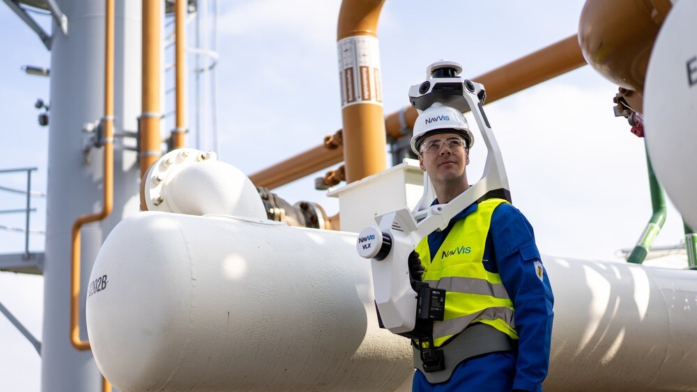
As mentioned, the new system includes two new 32-layer lidars – the NavVis VLX 2 included 16-layer lidars – carrying a range of up to 300 meters while capturing almost 1.3 million points per second. In a “dedicated test environment of 500 square meters,” NavVis found an accuracy of five millimeters. In addition to the lidars in the system, the NavVis VLX 3 also includes four high-resolution (4 x 20 megapixel) cameras around the top of the system for 360-degree panorama. The two-set battery system, which is hot-swappable, lasts 90 minutes on a charge.
In addition to those specs from the new system, the NavVis VLX 3 also includes a built-in touchscreen interface feeding live data, ensuring that a user captures an entire area as they are moving through a space. Furthermore, they’ve continued to improve the ergonomics of the system with their forward-facing design and padding, while also making it easier to transport. The NavVis VLX 3 weighs in at 8.5 kg – slightly lighter than the previous generation – and has a new folding design. With this folding ability, the NavVis VLX 3 can be transported in a hard-shelled case for air and rail travel, as well as with a backpack to bring the device on-site more easily. That said, right now the backpack is only available in Europe.
The continued innovation in this space is indicative of how important the technology is becoming in recent years, and that trend is only expected to accelerate in coming years. A wide range of emerging technologies and tools require accurate 3D mapping of all kinds of spaces, both indoors and outdoors. The NavVis VLX systems specialize in this mapping, and the NavVis VLX 3 release promises to both improve accuracy and make it easier and more practical for a wider range of users.
With the advent of Industry 4.0, or the Industrial Metaverse, or whatever other moniker which may be used, this type of data is crucial, and NavVis is positioning themselves to be key to this, particularly for large indoor spaces like factories and warehouses. This idea has been exemplified by their upcoming integration with NVIDIA Omniverse, which is one of the leading platforms for this Industrial Metaverse idea.
In a testimonial on the NavVis website, Paul Henzell, Managing Director at 360 Degree Mapping, said, "NavVis VLX 3 is a no brainer for us really. It became clear quite soon into the discussions that the system is in a class of its own when compared to existing mobile mapping solutions out there. The range and clarity of data is exceptional and on par with terrestrial solutions."
In a press statement, NavVis CEO and co-founder Felix Reinshagen added, “We’ve always pushed the boundaries of what is possible in dynamic scanning. NavVis VLX 3 is our answer to those who have been putting our technology to the test. What was once deemed impossible in the fields of surveying and laser scanning are now realities, and we are delighted to continue driving the industry forward with the launch of our brand-new device.”
NavVis is continuing their production of the NavVis VLX 2 system, so both the NavVis VLX 2 and NavVis VLX 3 are available for orders.


