We know that one of the most powerful uses of geospatial data and technologies is in response to emergencies. This is something that came up in Geo Week News’ recent conversation with Overture Maps Foundation CTO Amy Rose, who said that she will know they are on the right track with their quest to create an ecosystem for open and interoperable geospatial data when they are successfully meeting the needs of that application. We’ve seen examples of how GIS tools are being used by firefighters, and the value of high-quality aerial imagery for responding to natural disasters like hurricanes. To put it simply, having that spatial awareness serves to make emergency responders more informed, and thus more effective.
These applications are generally talking about these responses on a larger scale, though, taking into account the reality of entire areas, whether it’s to respond to a more confined emergency in the case of firefighting or prioritizing areas of focus following disasters of wider impacts, such as the hurricane example above. Geospatial tools can also be used on the ground in time-constrained emergencies, too, providing crucial real-time information that can literally save the lives of those responding to sudden emergencies.
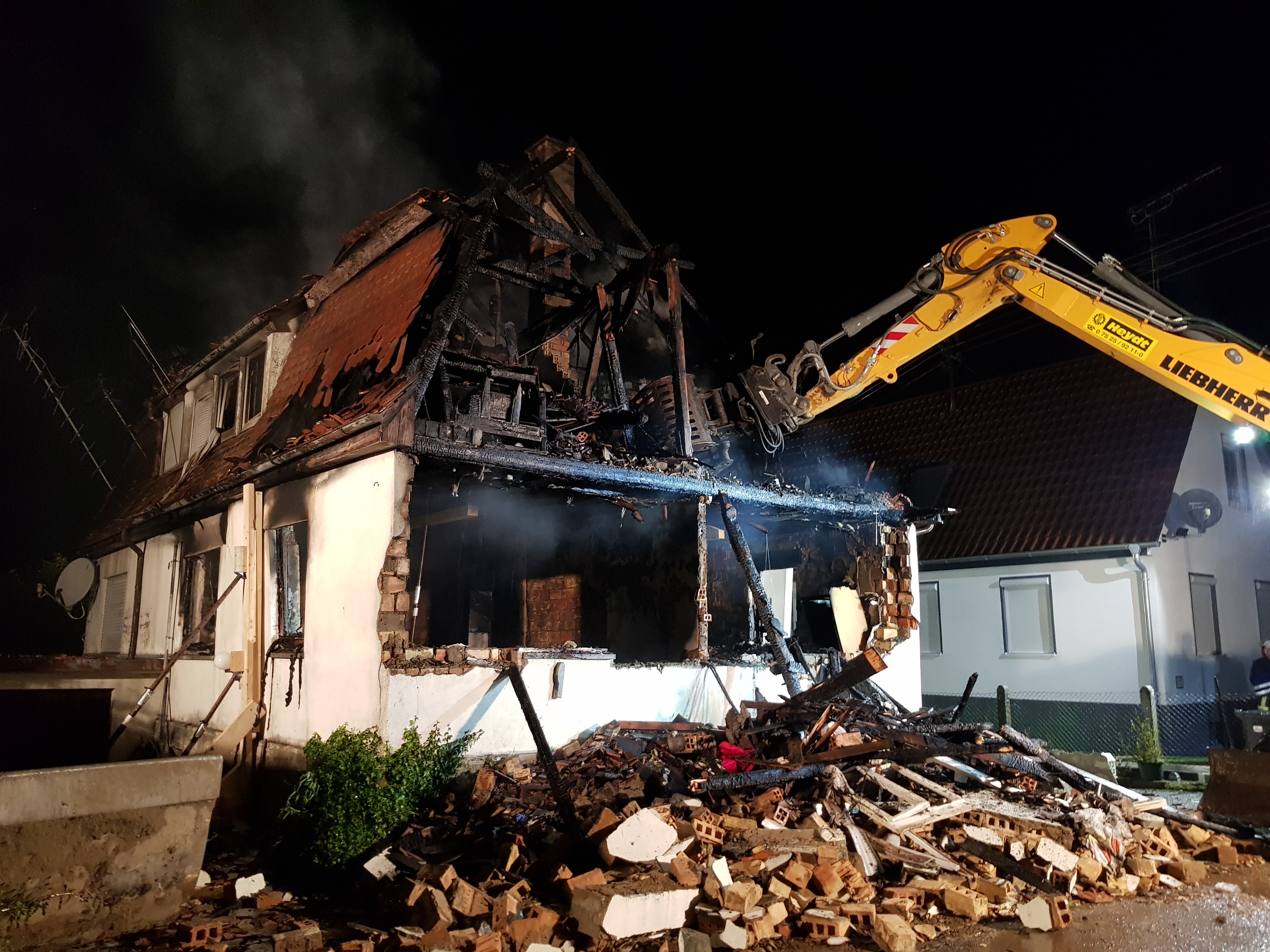
This is the kind of technology often used by Germany’s Federal Agency for Technical Relief (THW), a volunteer-based organization that provides technical assistance in Germany in critical situations. Recently, Geo Week News spoke with Kevin Kärcher, a specialist advisor with THW’s local association in Weingarten, about a specific incident in nearby Aulendorf in which THW assisted first responders at the scene of a partially destroyed building using Leica Nova MS50 Multistation.
To set the scene, Kärcher tells Geo Week News that the incident in question happened in September of 2019, and THW was alerted that night to an incident involving a partially destroyed building. Following what was a suspected explosion and resulting fire, there was one person from the residence still missing, for whom a search and rescue team was going to try to retrieve. THW was called to the scene to set up the Site Security Monitoring System (ESS), which involved the usage of advanced laser measuring technology – the aforementioned Leica Nova MS50 – to monitor the stability of the structure.
Assisting on the scene for this kind of high-pressure situation is exactly what THW is meant to do, with Kärcher telling Geo Week News they are generally tasked with “support measures, surveying of hazardous areas, and ensuring coordination with the incident command.”
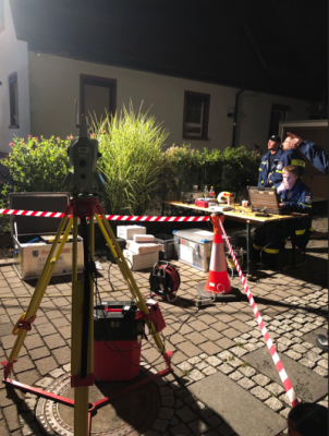
For this particular case, the agency’s job was to monitor the structural integrity of the building quickly and accurately to ensure it was safe for the rescue team to search for the missing person. That first involved setting up prisms on the structure that would ultimately form the basis for the measuring, but the circumstances made that more difficult than it would be in normal workflows, as they had a short amount of time to start collecting data.
“In this situation, you don’t have much time. It’s only about 15 minutes,” Kärcher explained. “So, we glue the prisms to the structure. We can’t screw them or remove parts, because the structural integrity is so critical.”
After the prisms are quickly and strategically placed around the structure, THW is then able to start using the MS50 to monitor any potential movement of the structure. Since they are sending rescue personnel into this structure, they need to be as confident as they can be that the structure is sound and safe for the mission. The only way to derive that value is with this kind of equipment.
“The amount of movement in these buildings after an event like this is very little, and you can’t see it with your eyes,” Kärcher said. “This is very important that we use the multistation and can warn if there is a dangerous situation.”
In theory, one might consider using drones or similar technology to make these measurements, as they are more accessible and generally easier to deploy. However, that kind of technology is not conducive to this work, where that extremely minimal amount of movement can be the difference between life and death. Whereas most drone-based scanning systems can provide accuracy to a couple of centimeters, the MS50 provides sub-millimeter accuracy. At that level, any sign of movement caught at that accuracy would give enough warning to evacuate the structure before a catastrophic event. In addition to these laser-based measurements, the multistation is also able to collect 3D data, providing 3D models that can be used for comparisons of the structure at different points of the rescue efforts for another layer of monitoring.
This application is just one example of the kind of work that THW does in Germany. As mentioned above, this is a volunteer-based agency, meaning that this is not full-time work for people like Kärcher, who provide this critical service. For him, his main job is as a mechanical engineer, which is where he started using laser technology for accurate measurement. It’s another example of how these technologies, which provide crucial value for private organizations – in this case, car manufacturers – can be used for the betterment of society as a whole.
Although this particular story happened six years ago, this remains a standard practice for THW in cases of building damage. Kärcher reported that the fire and police services have responded “very positively,” saying, “The visualization of building movements significantly raised safety awareness.”