
2011 tornado destroyed 60,000 lines of aerial mapping products
Three years after being destroyed by a tornado, the U.S. Army Forces Command broke ground last week in Fort Bragg, N.C., to rebuild its Geospatial Readiness Center.
The 25,000-square-foot, $7-million GRC will be used by soldiers from the 100th Engineer Company and civilian staff members to coordinate map and data transfers between the National Geospatial-Intelligence Agency and U.S. Army units across the country.
Real-time geospatial data – such as topography, terrain and roads, and the impact of the weather and time of day – is a fundamental element of battlefield intelligence.
Since the original building’s destruction in 2011, geospatial information techs and specialists have been spread across the base in available office space, supporting U.S. Army formations through its mapping database and collection of imagery.
The GRC’s primary focus is supporting Fort Bragg-based units such as special operations forces, the 82nd Airborne Division and XVIII Airborne Corps. The GRC may also be used to support FORSCOM’s corps and division headquarters nationwide.
“The geospatial intelligence piece of our Army, as we evolve to an expeditionary force, is going to demand all of our best efforts,” said Col. Todd Megill, FORSCOM’s deputy chief of staff for intelligence, in a statement.
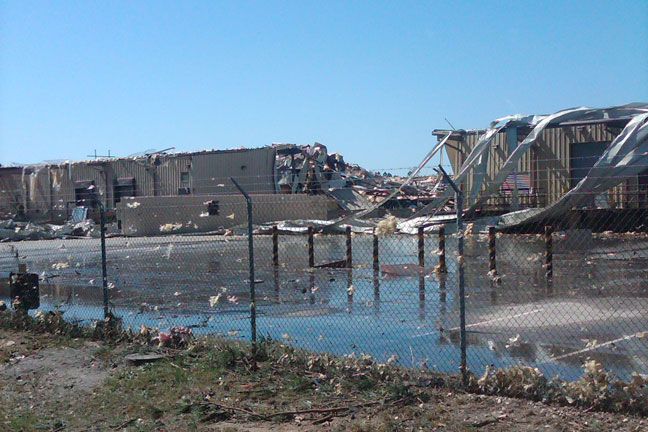
The 2011 tornado left a mile-wide swath, destroying or damaging hundreds of homes and businesses. It was one of 178 confirmed tornadoes across 16 states over a three-day span.
The twister destroyed the former, 28,000-square-foot GRC, including the warehouse, where most of the 60,000-plus lines of mapping products were destroyed.
Fortunately, no one was in the building when the tornado struck and the classified mapping stock was stored in a vault area unaffected by the storm.
“Within three years [of the center’s destruction], to start a project like this and to bring together all of the [geospatial intelligence]capabilities at Fort Bragg and FORSCOM, is pretty significant,” said FORSCOM Chief of Staff Maj. Gen. Les Carroll..jpg "12.26.13gen33")
Leaders of U.S. Army Forces Command break ground in Fort Bragg
The re-established Geospatial Readiness Center is slated to be ready for use by the summer of 2015.


