For surveyors working on sprawling transportation projects or complex utility corridors, the promise of AI comes with a catch. When the AI finishes processing and presents a lengthy dataset extraction, how do you verify it's correct? Where do you even start?
This tension between automation's efficiency and a surveyor's desire for preciseness has shaped the evolution of Mach9's latest release of Digital Surveyor, which will debut at Geo Week 2026. Following a year of customer feedback - especially from teams overseeing complex, extended projects - the company chose to reimagine AI usability and strengthen confidence in its outputs by redesigning their workflow to center on interactive collaboration between AI and surveyors.
"If ChatGPT just spits out a 40-page essay and you have to read the whole thing in order to understand all the places it's hallucinated to fix it, it's overwhelming," explains Alex Fischer. "It's not how you want to work. You'd rather work with AI to write that essay in real time, incorporating and accepting suggestions and also incorporating your own work along the way."
That analogy captures the core challenge Mach9 set out to solve. Even when automated extractions were technically accurate, reviewing the entire output felt like archaeology, sifting through results to find potential errors rather than building the deliverable with confidence from the start.
Bridging the Gap from Reality Capture to Production
The shift in workflow philosophy addresses a problem that extends beyond any single software tool: interoperability. Reality capture technology has advanced dramatically, with surveyors collecting increasingly rich datasets in the field. Yet translating that data into usable CAD and GIS models for engineers, designers, and construction teams remains a persistent bottleneck. That gap puts added pressure on surveyors to validate and shape data before it reaches downstream teams.
"There's a huge challenge between taking reality capture data or geospatial data and turning it into usable CAD and GIS models," says Alexander Baikovitz. "There's all this great data that people are collecting out in the field, but often, rarely does it get to those that are making the designs themselves."
Mach9's approach positions surveyors not just as creators of preliminary design maps, but as stewards of spatial lidar data, responsible for transforming it into actionable maps and models that different parts of an organization can actually use. This requires more than just extraction algorithms; it requires workflows that let surveyors maintain quality control while moving at the pace modern projects demand.
From Output Review to Real-Time Collaboration
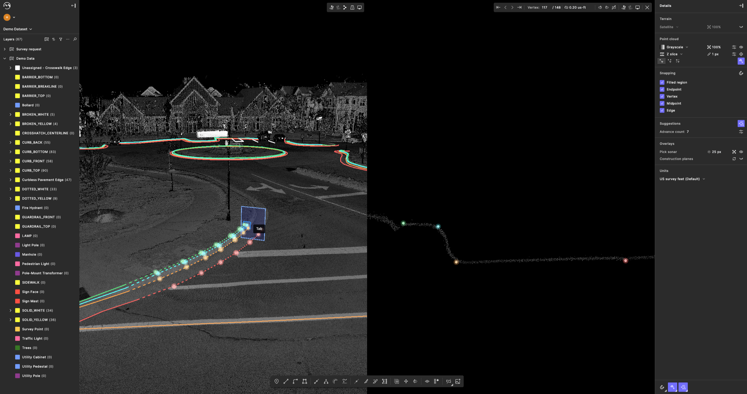
The rebuilt workflow represents a fundamental rethinking of how AI assists during the process. Rather than generating complete automated outputs for later review, the system now works alongside surveyors as they build deliverables, offering suggestions and intelligent assistance at each step.
Key improvements include clearer feedback during data selection, smarter snapping that helps geometry land where surveyors expect it, and quality assurance integrated directly into the work process. The result is a production environment where surveyors can create finished deliverables with confidence, then export them to CAD and GIS systems for downstream processing.
This release specifically targets professionals working on corridor and site projects, transportation corridors, utility infrastructure, and DOT work where extraction has long been a major bottleneck. These projects are often massive in scale and complexity, with deliverable requirements that demand both speed and precision.
The Trust Problem at Scale
"Once automation works, the hard problem becomes trust, control, and usability at scale," Baikovitz emphasizes. "That's what this release is really all about, providing surveyors with the ability to create maps really fast while having control for what those maps look like and how they're delivered."
It's a problem that only becomes apparent when automation starts working well enough to handle real production work. The technology can extract features accurately, but if surveyors can't easily verify that accuracy or adjust results to meet client specifications, the automation creates as many problems as it solves. Trust requires transparency, understanding what the AI is doing and maintaining control over the final product.
Experience the New Workflow at Geo Week
Geo Week 2026 will mark the first public demonstration of this rebuilt approach. The Mach9 team recognizes that the new workflow and integrated quality assurance are difficult to appreciate through screenshots or written descriptions alone. They need to be experienced hands-on, with real data and real project scenarios.
The company plans to sit down with surveyors and geospatial professionals throughout the event, walking through actual projects and allowing attendees to work directly with the new tools. For those managing large-scale extraction projects or struggling with the transition from field data to final deliverables, it's an opportunity to see how the balance between AI assistance and human control is being recalibrated.
For more information about Mach9's presence at Geo Week, contact the company or visit them at the event at Booth #1703.
About Digital Surveyor
Digital Surveyor provides AI-assisted software solutions for surveying professionals, focusing on transforming reality capture and geospatial data into actionable CAD and GIS models for engineering, construction, and operations professionals.