

EagleView is a provider of geospatial data and solutions to customers in a variety of industries and sectors such as government, construction, infrastructure, and solar to name a few. Its TrueDesign solution is a web-based 3D visualizer that will auto-generate final, install-ready Photovoltaic (PV) designs based on the data derived from their aerial imagery. Other deliverables based on aerial imagery are highly accurate 3D environments, shade scenes, roof dimensions, and power production estimates. EagleView’s imagery covers 94% of the US population and continues to expand as the company captures more imagery for customers and the market to meet their needs.
Simplifying the experience of creating a digital twin
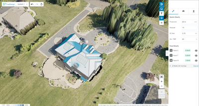
TrueDesign is similar to a CAD or GIS application but is focused on the residential PV solar workflow per property. Solar contractors within the US who sell and install a PV system are required to model the project's site, which includes a model of the home and the surrounding environment to understand the impacts of the PV system on the roof. EagleView leverages its ortho and oblique imagery to generate these 3D and Digital Surface Models (DSM) as well as running spatial analysis to derive a highly accurate shade scene for the contractor to simplify the experience of creating a digital twin of the home and understand production based on any module layout.
Since EagleView does all of this data processing before delivery to the customer, TrueDesign allows users to focus on the layout and offset what would be best for the homeowner without needing the CAD or GIS digitization tools of most solutions in the market. Due to the accuracy of Eagleview’s data, if used during the sales process, contractors can accelerate their post-sale activities to get to installation faster. Many solutions in the market require the contractor to manually rework the projects sold to the homeowner due to inaccuracies in the data used at the point of sale. This practice causes a lot of waste and delays in projects, ultimately impacting the contractor's cash flow and customer acquisition costs.
TrueDesign Version 2.0
Recently, the company announced the launch of TrueDesign Version 2.0, the latest release of its solar design solution. TrueDesign Version 2.0 introduces a host of new features and enhancements that make designing solar panel systems faster, more accurate, and more intuitive. Some of the key features of TrueDesign Version 2.0 include proposal integration, improved shade analysis, and a realistic 3D visualization environment based on a Digital Surface Model (DSM) derived from high-resolution aerial imagery. EagleView generates its own Digital Surface Models from ortho and oblique imagery. The resolution of a DSM depends on the resolution of our imagery available in that area, but the typical Ground Sampling Distance (GSD) is about 1 to 4 inches.
CAD file download option
TrueDesign allows companies to scale to meet the increasing demand for residential solar. Users can sell from an install-ready design, reduce or eliminate site visits and download CAD files that streamline the permitting process, with minimal labor and almost no solar design experience required.
TrueDesign is broken up into two components to support the contractor during the project lifecycle – Sales and Planning. The Planning component supports CAD export of the project. If the user has purchased TrueDesign for Planning, it is a simple one-click download to access the CAD data. TrueDesign only supports DXF format, which works for AutoCAD applications and other open-source alternatives. The DXF exports include a 3D model of the home with complete line classification of the structure, 3D obstructions (chimney, vent pipe, etc), setbacks, module layout, and embedded solar data such as solar access values and total solar resource fraction every six inches on the roof. Eagleview also includes an aligned orthoimage and breaks out each facet in 2D to support plan sets. Many contractors take this output and use paper layouts in AutoCAD to generate a plan set themselves. This CAD data is also available in XML which many integration partners consume to help create plan sets as well.


