Reliable positioning is fundamental to nearly every modern technology that moves, maps, or measures the world around us. From autonomous vehicles and robotic systems to survey-grade instruments and emergency response operations, accurate localization underpins safety, efficiency, and situational awareness. Yet the industry’s dependence on Global Navigation Satellite Systems (GNSS) presents a critical vulnerability. In many environments, satellite signals are weak, obstructed, or can be intentionally disrupted. Urban canyons, tunnels, dense forests, and indoor or subterranean settings all represent “GNSS-denied” environments where traditional positioning simply fails.
This problem is not limited to extreme conditions. Even in day-to-day operations, such as mobile mapping in a dense city or an autonomous vehicle passing under a bridge, GNSS degradation can cause significant drops in accuracy. For systems that rely on continuous localization, those interruptions can be costly or even dangerous. Maintaining high-quality positional awareness in all environments has therefore become one of the defining technical challenges in modern geospatial and autonomous system development.
Meeting this challenge has historically required significant engineering effort. Building a system capable of maintaining accuracy when GNSS signals are compromised or blocked often demands complex sensor integration and extensive software development. For organizations working in mapping, construction, and autonomous systems, these integration challenges translate directly into higher costs, longer project timelines, and operational uncertainty.
For years, Oxford Technical Solutions (OXTS) has built a reputation for precision and reliability within the automotive sector, delivering high-performance inertial navigation systems that combine GNSS technology with inertial measurement units (IMUs). These systems have long excelled in so-called “open-sky” environments, where satellite visibility ensures maximum accuracy. Drawing from this deep foundation in GNSS/INS and sensor fusion, OXTS has recently expanded its focus to address one of the most pressing frontiers in positioning technology - reliable localization in GNSS-denied environments.
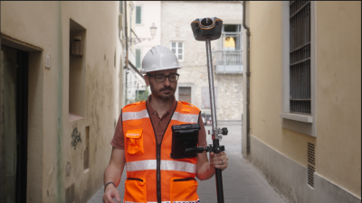
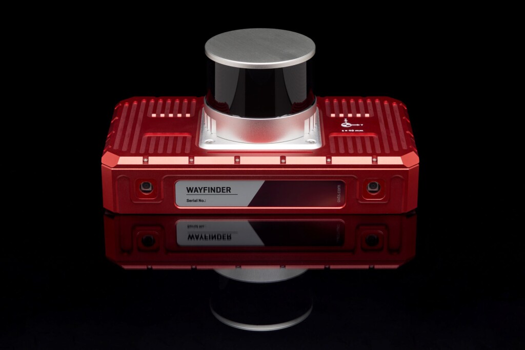
That pursuit led to the development of OXTS WayFinder, a multi-sensor localization system designed to deliver consistent, high-accuracy positioning whether GNSS is available or not. Instead of requiring users to source, configure, and synchronize their own components, OXTS has pre-engineered a cohesive system in which all parts work seamlessly together.
At the core of WayFinder’s architecture are three key components:
Inertial Navigation System (INS): The system’s foundation is the IMU10 inertial measurement unit coupled with a pair of GNSS receivers capable of tracking all four global constellations. This provides precise measurements of motion, acceleration, and orientation at the same time, which can provide stability and accuracy even if satellite coverage fluctuates.
Lidar Sensor: A 360-degree lidar scanner provides a detailed view of the surrounding environment which provides spatial awareness and geometric mapping that can be used to maintain localization when GNSS data is weak or unavailable.
Camera Array: Two onboard cameras contribute additional visual context, supporting algorithms that identify features, track movement, and enhance environmental understanding.
A key innovation powering this capability is LiDAR Boost, a suite of algorithms that use data from the integrated lidar to maintain accuracy when satellite signals degrade or disappear. When GNSS updates are unavailable or unreliable, LiDAR Boost compensates in real time, allowing the system to transition smoothly between GNSS and lidar-based localization as the operating environment changes without manual intervention. LiDAR Boost works by constraining the natural position drift that occurs when INS loses a GNSS signal and errors from the IMU begin to accumulate.
The system employs lidar data in two ways to enhance the accuracy of the data produced by the GNSS/INS:
1. Real-time Lidar Inertial Odometry (LIO): LIO is an existing OXTS technology that analyzes the lidar data to detect planes and objects and tracks how they move between captured frames. LiDAR Boost executes this capability in real time, using the data to calculate relative velocity updates that the OXTS GNSS/INS can use. This is ideal for areas where GNSS signal is patchy, or for temporary outages like tunnels, and helps protect against multipath errors common in cities.
2. Lidar Map Matching (LMM): By creating a feature map of an area, LMM can compare the real-time data gathered by the lidar scanner with that existing map to produce position updates within that space. Because these position updates rely on the point cloud data, the results are accurate, reducing drift. LMM is crucial for activities like autonomous navigation and ground truthing, where repeatable results are vital.
The result is a system that delivers real-time, uninterrupted localization data, ensuring that operations continue seamlessly across both open-sky and GNSS-denied spaces. For geospatial professionals, surveyors, and engineers, this means a new level of resilience and dependability in environments that were once considered difficult or impossible to map accurately.
The ability to get reliable localization data anywhere is no longer a luxury but a crucial capability. As the geospatial and infrastructure industries move toward greater autonomy and automation, solutions like WayFinder highlight the growing importance of sensor fusion and intelligent navigation.
For more information about WayFinder, check out the WayFinder overview or get the full specs.