Contributed by Forsite Consultants Ltd.
LiDAR usage in forestry is becoming more and more common as firms and governments recognize the advantages and cost-saving potential for engineering and survey purposes. The more elusive and challenging problem is cracking the inventory case. That is, what do you do if you have millions of acres or hectares under management and no good way to inventory those assets? LiDAR offers a solution to produce individual tree characteristics. The latter has been shown in many studies over the past decade or more but... how do you scale it?
Forsite Consultants Ltd of Salmon Arm, BC have cracked the code with their Tree Species Identifier software system (TSI). TSI, now in its tenth year of operation, was built to identify individual trees from LiDAR, satellite, and other remote sensing data at an industrial scale. While experiments and studies can be found in academia looking at tree identification in 100 acre blocks or even 1,000 hectare stands, TSI brings a big data framework to process millions of acres of territory and hundreds of millions of individual trees in a given project. In 2021, the software system was used to inventory 4.2 million acres and close to a billion trees; each tree attributed with height, species, canopy area, live canopy percent, slope, aspect, and diameter at breast height.
Creating the inventory is just the first step for clients who will use that information for timber management, carbon assessment, wildlife habitat mapping, and operational harvest planning. From the time the LiDAR is flown, the clock is ticking to ensure the inventory can be used while the snapshot is still fresh. The individual tree inventory can also be used as the foundation for future growth and yield estimates. With the tree inventory complete, cost-effective updates using photogrammetric imagery & point clouds in subsequent years can keep height and tree health data current.
How do you deal with that much data in a useful time frame?
Forsite leverages cloud computing to address both the storage and rapid processing of the project data. This TSI design focus allows the analysts to spend their time on segmentation calibration and species accuracy rather than tedious days or weeks waiting for terabytes of LiDAR to process.
TSI's success is based on its industry-leading individual tree segmentation algorithm. TSI searches the point cloud for both trees at the canopy and in the understory.
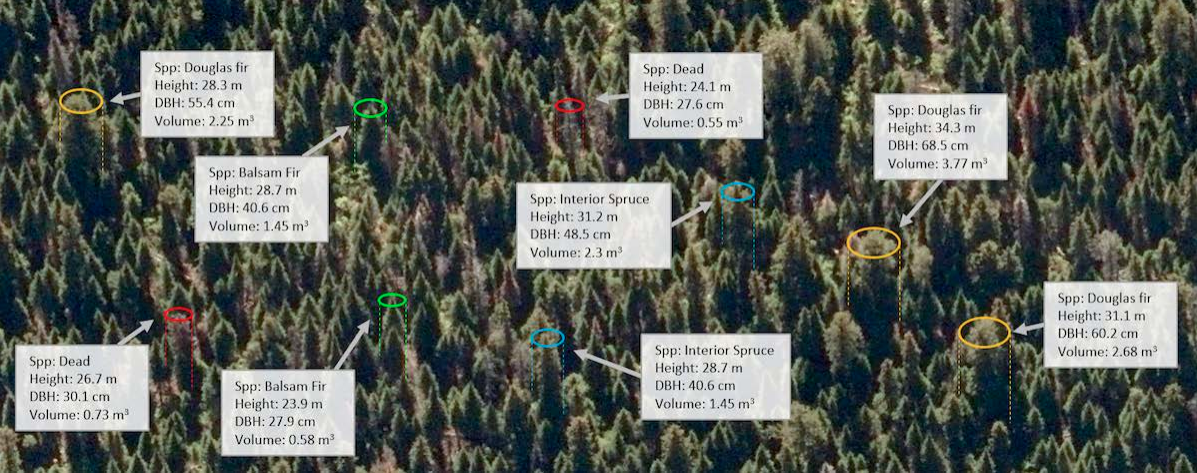
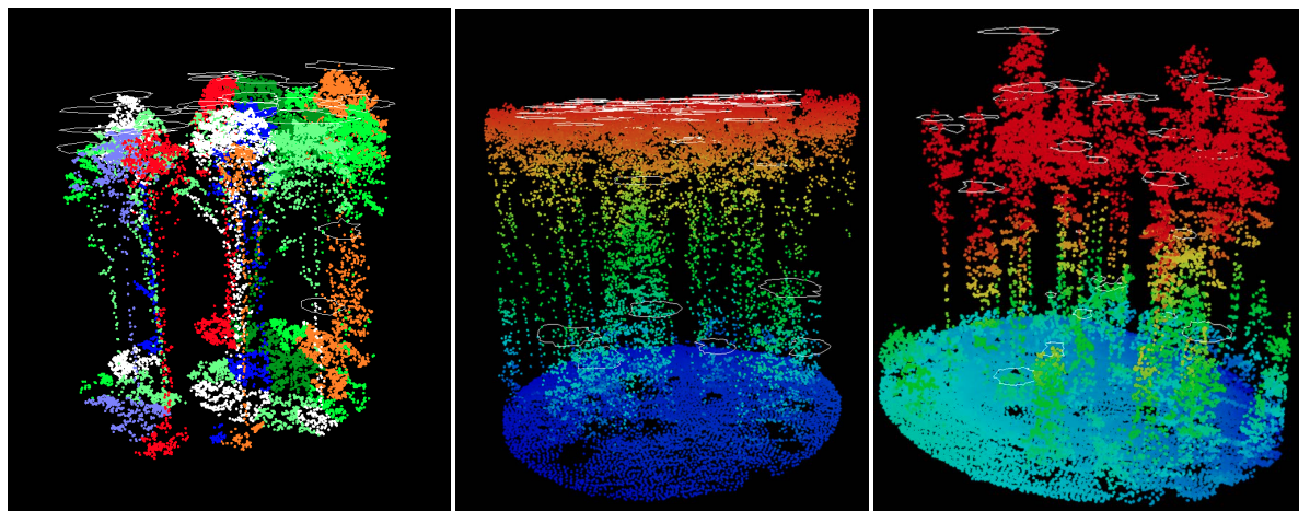
This level of information extraction is key for clients looking to determine the extent of understory softwood or wildfire fuel metrics.
What does a typical project look like?
In 2020, Forsite completed an individual tree inventory for West Fraser Blue Ridge Lumber. The project area was about 660k ha (1.6 million acres) and is located in Alberta's boreal forest. LiDAR was flown at a point density of 16 ppm in order to provide better canopy penetration and understory definition.
"The identification of understory softwood (species and height), is a key deliverable for our clients east of the Rockies. We talk a lot about precision forestry and the benefits of digital twinning; reduce risk, save time, increase ROI.," says Mike Parlow, Team Lead for Remote Sensing Inventories.
"This really underlines where a remote sensing approach redefines the client's business case paradigm. Creating an inventory of understory spruce is the sort of land base intelligence that simply isn't available any other way and it necessitates a change at the operational harvest level. Harvest projections and operational plans can be finely tuned to market requirements (the value by species) and mill capacity (height and species allows for piece size estimates)."
In Q1 of 2022, Forsite completed it's first individual tree inventory using single photon LiDAR (SPL). The inventory covered 100,000 hectares (247k acres) in Ontario's Romeo Malette Forest.
"SPL isn't new anymore but its recent enough that the industry is still proving out use-cases." said Trevor Hooper, Remote Sensing Technology Developer.
"We were very happy that TSI was able to ingest the Leica SPL data and create an inventory that fully met or exceeded our accuracy standards. As the Province of Ontario has undertaken to fly SPL across Ontario's forests, the success of this project really opens up the range of possibilities for the forest industry."
Explore what your Innovative Forest Inventory could be... Learn More >>