In the early morning hours of April 16, 2016, the ground in Kumamoto Prefecture began to shake. A cluster of earthquakes, reaching up to 7.0 in magnitude over the coming days, destroyed homes and buildings as it shook the earth. When the tremors subsided, it was discovered that one of the finest buildings in Japan had been caught in the wave of devastation. Kumamoto Castle, rebuilt in 1960 and considered to be one of Japan’s premier castles, had suffered extensive damage.
While the castle itself withstood most of the earthquake with minor structural damage, it was soon discovered that two of the castle's keeps had partially collapsed. Elsewhere, several of the exterior walls at the base of the keep had also crumbled, while a large volume of roof tiles had been shaken loose and crashed to the ground.
Soon after the earthquake, the city called upon engineering firm Kozo Keikaku Engineering Inc. (KKE) to survey the damage. For KKE, this project was also historically significant, as their firm had undertaken the original restoration of the castle keep when it was rebuilt in 1960 – an effort personally overseen by KKE’s late founder, Dr. Makoto Hattori.
When photographs are no longer enough
The first step towards restoration and repair is site documentation, but this can be a major obstacle when historical buildings are involved, says Koichi Kakuta, Sales and Marketing Representative for KKE.
“In Japan, various natural disasters such as earthquakes, tsunamis, typhoons, and landslides often occur, and historical buildings can also be damaged. Damaged historical buildings may not have BIM, CAD data, or even paper drawings, and it can take a great deal of time to restore them.”
Assessing the state of the site and documenting damaged areas was also made particularly challenging by the relative inaccessibility of the most damaged areas and the large size of the Castle and grounds.
While engineers did take numerous photographs of the damage inside the castle at each visit to the site, when they were reviewed back at the office, they found there were sometimes gaps in what was collected. For Junichi Tashiro, Chief Examiner, Kumamoto Castle General Office, it soon became clear that cameras would not be enough.
“Immediately after the disaster, I went back and forth between the office and the site several times a day to take pictures of the damage inside the castle tower with my camera. However, there were many details that I could not capture.”
NavVis mobile mapping provides a new way of seeing
After early assessments revealed the extent of the damage, the experts at KKE knew that another approach was needed, and immediately proposed using NavVis reality capture technology for damage assessment. Moreover, the team believed that the technology could make a substantial difference in the restoration process as well. With a 360-degree scanner, KKE could now capture the damage inside the keep, and visualize the information as 3D panoramic images and point clouds.


The team from KKE performed a pair of scans using NavVis mobile mapping hardware, viewing and sharing the results via NavVis IndoorViewer (today known as NavVis IVION). The first scanning effort took place in September 2016 which documented the damage in place before maintenance teams started any removal work. This initial snapshot was used to plan a portion of the interior demolition work. In April 2017, when the interior demolition began in earnest, KKE once again returned with a NavVis mobile scanning system to capture another snapshot.
When viewing the scans, Mr. Tashiro was able to see more than the photographs alone could provide.
At this stage in the restoration of the keep, the team was able to check the interior and compare it to its initial state with NavVis software – without having to sort through a multitude of photos.
Rather than taking up time to search through extensive photo documentation, NavVis visualization software helped KKE to attach relevant bits of information, such as drawings and photos, to a geo-tagged Point of Interest (POI). Together, the site scan and POIs provide a clear picture that was understood both by the engineering team and other stakeholders. This ability to compare the past to the present was crucial in monitoring the project.
After the initial work to remove the earthquake-related debris, Kumamoto representatives put together a restoration plan for the castle keeps. Due to the magnitude of the damage, restoration with reopening for the keeps was scheduled to be by 2021, as for the full restoration plan of the castle, it is currently estimated for completion in 2038.
NavVis VLX adds even greater versatility
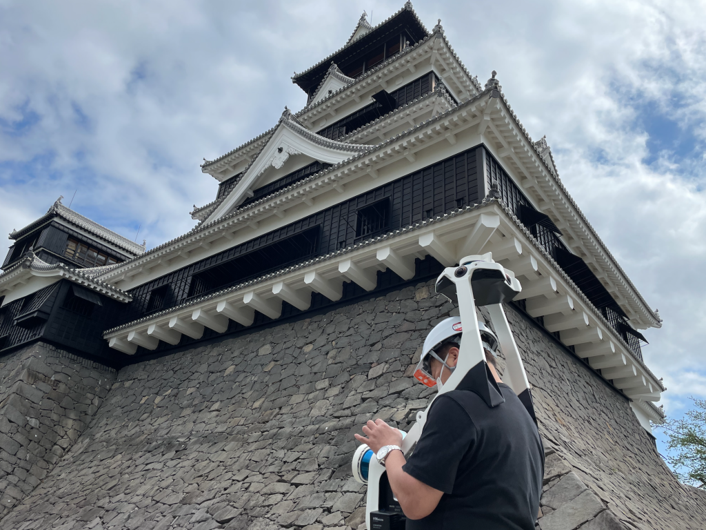
As planned, in April of this year - almost five years to the day after the fateful earthquake - members of the KKE scanning team returned for a comprehensive scan, this time armed with NavVis VLX, a shoulder-mounted mobile mapping system.
The team, who had not seen the site in person in quite some time, were amazed to see how beautifully the keep stone walls had been restored, and quickly carried out a complete scan using NavVis VLX. Over two days, a total of 10,800 square meters was captured, which included both areas inside the castle keeps and the outer circumference of the castle keep.


The greater portability and ease of use of NavVis VLX in performing the scans was notable to Mr. Kakuta.
“We were able to measure outdoor and indoor stairways, as well as narrow areas in the backyard. It took only two days to complete indoor and outdoor measurements. In addition, the storage case was about the size of a suitcase, so it could be transported by airplane.”
 Compared to the previous scans, NavVis VLX offered the additional versatility of being hands-free, and far easier to move about the castle due to its lack of wheels, reflected Eiji Miyagaki, the person in charge of measurement for the project at KKE.
“It was hard work in the hot and humid early summer in Japan. If I had a NavVis VLX at the time [of the first scans], I would have been able to go alone and make scanning of a much higher quality and shorter time,” said Mr. Miyagaki.
Realizing the power of a digital twin
In new construction, or even in as-built structures, it is straightforward to do a site visit – but in situations as complex as this, that’s not always an accessible option. To document difficult areas in a building takes time, personnel costs and can even have potential safety concerns. In addition, it can be hard to inspect areas that don’t have corresponding photos or drawings or to find the right photo. Creating a 3D digital twin, however, can make repeated site visits less necessary, and put visuals into a more comprehensive view for better understanding.
Indeed, the data captured with the NavVis mobile mapping system helped to compile the damage reports. Above all, a digital twin of the castle keep before the 2016 earthquake might have made the restoration more efficient, Mr. Kakuta (KKE), reflected.
“With NavVis VLX, it is possible to quickly measure indoor and outdoor areas of large-scale historical buildings, and by displaying the obtained data in NavVis IndoorViewer, it is possible to understand 3D shapes with point clouds, and to check materials and colors in detail with panoramic photos, and to share, instruct, and report data anytime and anywhere. And with NavVis IVION, innovative new features such as multi-site and cloud processing can increase the efficiency of these mapping and display tasks many times over.”
For the Chief Examiner of Kumamoto Castle, this new process has inspired them to find even more applications for NavVis reality capture.
“In the future, we hope that NavVis can be used not only for the restoration of Kumamoto Castle, but also for other important cultural properties in Kumamoto Prefecture and the country. If we can accumulate the history of restoration, maintenance management, we will be more efficient, which will lead to longer service life and cost reduction,” said Mr. Tashiro.