

“The automated, AI-supported derivation of infrastructure objects from laser scan point clouds enables an enormous increase in efficiency and cost reduction for the inventory of road infrastructure.” Roland Degelmann, Bavarian State Ministry of Housing, Building and Transport
As 3D scanning technologies for mobile mapping have evolved, their applications have expanded – including the scanning of highways and other horizontal infrastructure. However, each scan of a section of roadway presents an incredible challenge: how to handle the massive amounts of data generated – and how to extract usable, relevant information from them.
These challenges are not unique to mobile mapping. The creation of point clouds for infrastructure projects can generate huge amounts of data in any 3D scanning scenario, but the challenges are especially great for miles-long highway digitization projects due to their sheer size combined with the need for millimeter accuracy.
The Bavarian State Ministry of Housing, Building and Transport is regularly tasked with surveying existing road networks throughout Bavaria – sometimes as a case-by-case basis for new construction projects, and other times with regularity to assess the conditions of road surfaces. These regular inspections are carried out at least every four years for road surface; comprehensive inspection for bridges occurs at least every six years. More frequent inspections for certain areas are performed in a matter of specific security concerns. Using BIM and digitizing these roadway assets is important as part of their planning and building goals, says Roland Degelmann, Head of Unit Digital Transformation at the Bavarian State Ministry of Housing, Building and Transport.
“With the introduction of digital models and processes, the advantages of digitization are combined with those of cooperative work processes in planning, construction and operation to increase quality as well as cost and schedule reliability.”
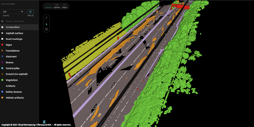
Rethinking Manual Classification
In their digitization workflows, Cloud-Vermessung + Planung GmbH, a surveying company, typically uses a Trimble MX9 Measuring unit to survey roads and takes lidar scans with RIEGL scanners. The recording of these scans generates large amounts of raw data, which traditionally have to be evaluated manually.
On behalf of the Bavarian State Building Authority, Supper & Supper has endeavored to use their SaaS solution, Pointly, to reduce the manual processing efforts and overcome challenges of scanned road and highway datasets once collected. At the start, Supper & Supper has used existing mobile mapping laser scans of sections of the A92 and A99, generated by Cloud-Vermessung + Planung GmbH, as a means to train the software. By automating the manual measurement of highways and overpasses, it will be possible in the future to assess much larger road sections in a fraction of the time.
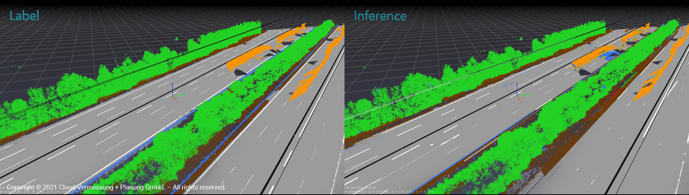
Road Manually classified by Supper & Supper (left) compared to the same road automatically classified by Pointly’s 3D neural network (right).
Pointly’s 3D neural network can be trained to recognize object classes reliably, and then to extract them automatically in future datasets. While the process does take some manual training in the beginning, once the network is trained, it can drastically reduce the manual classification needed when future datasets are ingested.
The first project phase started in the fall of 2020. High resolution laser scans with sections of the highways A92 and A99 were provided to be labelled in Pointly with precisely defined object classes, like roads and road markings. With these labelled scans as training data, Supper & Supper’s data scientists then trained the 3D neural network. In further project phases, bridge structures, signs, etc., will be added.
The goal of the first project phase was to provide classified point clouds with the detected elements, and to assess the accuracy of the object recognition process. The analysis compared the cost and time required by previously used methods to the AI and SaaS solution. The result was that with the approach of Supper & Supper and Pointly a much more cost- and time-effective process is possible in the future.
The ongoing second phase involves the creation CAD annotations from the classified point clouds with a second graph encoding neural network, and there have already been some very promising results.
A Promising Future for AI
While this project is ongoing, it can be seen as a signal that the use of AI for extracting information from point clouds is not in the realm of science fiction, but something that is possible for real-world projects. The manual evaluation of point clouds has always been a taxing step for 3D scanning, and one that can give pause to time-crunched project managers.
With AI-supported workflows like what Supper & Supper is implementing with Pointly and a small investment in training, AI tools can be leveraged to enable new scalable use cases and drastically reduce costs and labor hours for future projects.
Start now with a free account and experience Pointly’s easy-to-use tools which accelerate your classification work.


