
Acute3D is happy to announce its partnership with Hanseatic Aviation
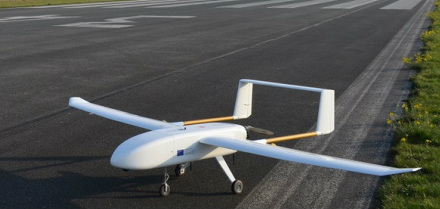
Hanseatic Aviation Solutions, Bremen (Germany) based company is specialized in the development and manufacturing of fixed wing UAV.Solutions.
S180 Mk.2 and S360 are high-performance UAV in the range from 4 to 25+ kg take-off weight and are characterized by the modular pay load concept for easy and fast exchange of different sensors.
These two UAVs are the ideal platforms to conduct airborne surveys on area scales typically from 1 sqkm up to hundreds sqkm.
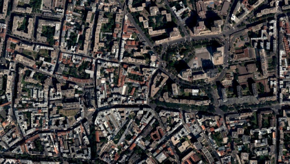
Hanseatic Aviation Solutions is now offering its customers a bundle including one of its drones and one license of Smart3DCapture, a leading software solution for automatic 3D surveying and mapping from photos, developed by Acute3D. Smart3DCapture allows to automatically generate a DSM, a true orthophoto, and an accurate 3D model from the photos taken by Hanseatic’s UAV.
About Acute3D
Acute3D develops and sells Smart3DCapture, a software solution allowing to produce high resolution 3D models from simple photographs, without any human intervention.
The principle of Smart3DCapture is to analyze several photographs of a static subject, taken from different viewpoints, and to automatically detect pixels corresponding to a same physical point. From many such correspondences, relative orientations of photos and accurate 3D shape of the scene can be inferred.
Smart3DCapture solves this problem with cutting edge photogrammetry, computer vision and computational geometry algorithms fulfilling industrial-quality requirements in terms of precision, scalability, efficiency, usage, robustness and interoperability.
About Smart3DCapture
Smart3DCapture Advanced allows the production of high resolution 3D models as well as the generation of digital surface models (DSM) and true orthophotos from imagery datasets as big as 10 gigapixels. It is most suited for, but not limited to, UAS/UAV/drone operators.
Smart3DCapture Expert pushes the limits of the Advanced edition with an extension to 30 gigapixels per input imagery dataset, and a batch processing ability through a job queue. It is the perfect solution for demanding scanning and surveying projects.
Smart3Capture Ultimate is dedicated to larger-scale 3D surveying and mapping. It can handle an unlimited number of photographs without any limitation in size, and allows computations to be parallelized on a cluster of 3D reconstruction engines.


