
Press release highlights:
- The company has updated its line of airborne LiDAR mappers, the Optech Galaxy ALTM units.
- The updates bring a 30% increase in efficiency.
- When Optech’s SwathTRAK and PulseTRAK technologies are added, the company claims collection efficiencies exceeding 70%.
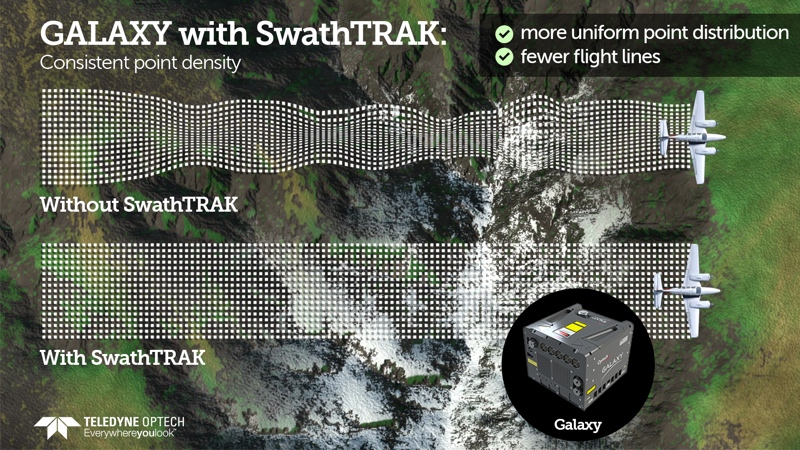
- SwathTRAK enables fixed-width data collections over variable terrain.
- PulseTRAK enables a “trull continuous operating envelope, thereby solving the multi pulse challenge of data coverage gaps.”
Teledyne Optech is pleased to announce a high-performance scanner update to its innovative line of airborne laser terrain mappers, the Optech Galaxy ALTM™. The Galaxy’s scan efficiency has been engineered to deliver an additional 30% boost to its class-leading area coverage rates. When coupled with its innovative SwathTRAK™ and PulseTRAK™ technologies, collection efficiencies exceeding 70% are possible, relative to the traditional fixed-FOV dual-beam sensors currently on the market.
According to Michael Sitar, Teledyne Optech’s Airborne Business Manager, “Operational cost reduction is a key driver for our clients. This new enhancement releases underlying performance in an already robust scanner design to enable significant increases in scan velocity and scan product. This translates to improved XY point distribution at higher laser PRF sample rates, faster aircraft speeds and wider scan FOVs, as well as dramatic increases in point density at lesser FOVs.”
The Galaxy is a giant leap forward in productivity and technology innovation that truly raises the bar in wide-area sensor performance. Central to the Galaxy‘s performance capability is a series of unique technology innovations and high-productivity feature sets that include SwathTRAK™ and PulseTRAK™.
SwathTRAK™ leverages a programmable galvanometric scanner by dynamically adjusting the scan FOV during flight and data acquisition, enabling fixed-width data swaths even in variable terrain. The advantage: fewer flight lines and more consistent point distribution, whether on hill peaks or valley bottoms, compared to traditional fixed-FOV sensors.
PulseTRAK™ enables a truly continuous operating envelope, thereby solving the multi pulse challenge of data coverage gaps and density variation in the multi pulse transition/blind zones. This gives surveyors the ability to use very high laser pulse rates and generate high point density in variable terrain, without the need for complex flight planning.
Boasting the same ultra-compact form factor as the award-winning ALTM™ Orion sensor platform for tier 2 UAV, heli-pod, gyro-stabilized or fixed-platform installations, the Galaxy also maintains the same exceptional survey-grade data precision and accuracy for the highest quality data sets in the industry. Whether it is high-altitude, wide-area mountain surveys above 4000 m AGL, or low-altitude corridor mapping initiatives, the Galaxy‘s superior dynamic range and exceptional small-target detection provides maximum application flexibility with no compromises in collection efficiency or data quality.


