

One of the issues on the forefront of many politicians and government employees in the United States right now is the country’s aging infrastructure. Passed in 2021, the Infrastructure Investment and Jobs Act (IIJA) put a larger spotlight on these issues, providing key financial assistance all around the nation to address all kinds of infrastructure, ranging from roads to bridges to mass transportation systems, all the way to things like electric grids and broadband access. With all of the money flooding into the space, it’s no surprise that innovation is following close behind, with companies starting to introduce technologies to help these newly-funded projects go as smoothly and efficiently as possible.
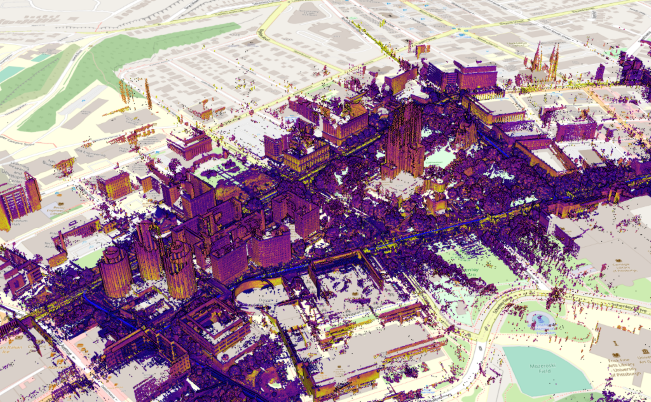
The timing of this funding works out well for a lot of these projects, as it lines up well with the democratization of reality capture hardware. That said, collecting the data is only half the battle, and software is the other key piece of this to process and analyze the massive amounts of data, often coming from multiple different sources. Mach9 is one of the companies who has developed software to address these issues, with a special focus on the infrastructure space. Earlier this month, the Pittsburgh-based company launched their new software platform, claiming that their product “produces 2D and 3D maps from mobile lidar 30x faster than existing solutions.”
In their release announcing the news, Mach9 highlights the speed of their platform, allowing for projects to move more smoothly and not have to deal with long wait times in processing large amounts of data. They also note that their software takes advantage of artificial intelligence (AI) and computer vision – two technologies experiencing a boom throughout the broader tech industry – to ensure those fast production times.
Mach9, founded in 2021, was borne out of the founders’ experiences researching the robotics space at Carnegie Mellon University in Pittsburgh, Pennsylvania. Per the company’s release, founders “Alexander Baikovitz, Haowen Shi, Michael Mong, and Zachary Sussman met during their time at CMU's world-famous Robotics Institute,” and ultimately “they realized that their combined experiences developing complex robotic systems for autonomous mapping and mobility could be leveraged to help infrastructure organizations adopt technologies that ultimately improve everyday life.”
Their location in Pittsburgh was also important to the development of these products, specifically the idea of them being centered in the infrastructure space. In 2022, after the founding of Mach9, the Fern Hollow Bridge in Pittsburgh collapsed, providing a clear and up close example of what’s at stake with repairing the country’s infrastructure. That event led to the company’s creation of their Pittsburgh Bridge Initiative, and was an inflection point in the development of this platform.
Things like that bridge collapse and train derailments around the country, among other tragic events, are reminders of how important all of the infrastructure around us are, and we know that lidar-based mapping of these structures can provide the best insights possible to ensure everything is as it’s intended, and what the best fixes are if anything is wrong. There’s also a big learning curve for processing and analyzing this data, as well as the aforementioned delays that come from trying to process such cumbersome amounts of data. It’s great that this additional funding from IIJA allows for broader adoption of these more accessible reality capture tools, but it’s crucial to be able to pair it with software that keeps projects moving efficiently. That’s the goal Mach9 is shooting for with this launch.
The organizations that own and manage our infrastructure are dependent on high quality maps. New mapping technologies, like mobile LiDAR, have transformative potential for engineering and construction firms, departments of transportation, electric utilities, railroads, and other government entities. However, the high costs and long wait times required to generate mapping deliverables are hampering the broad adoption of these amazing tools," says Alexander Baikovitz, co-founder and CEO, in a press statement. "Our goal at Mach9 is to unlock this potential by creating a geospatial production platform for those that need high quality maps and actionable data fast.”
Along with announcing the launch of this platform, Mach9 also announced a move of their corporate headquarters to Pittsburgh’s Bloomfield neighborhood, as well as the hiring of software engineer Josh Dague, which they say “establishes a presence in Silicon Valley” for the company.


