The geospatial community lost one of its most important pioneers this past weekend. Dr. Gladys West, the mathematician whose groundbreaking work created the foundation for the Global Positioning System (GPS), passed away peacefully on January 17, 2026, at the age of 95.
For an industry built on precision, accuracy, and innovation, Dr. West's contributions cannot be overstated. The mathematical models she developed during her 42 years at the Naval Surface Warfare Center didn't just enable GPS; they catalyzed an entire industry. Today, every surveyor using RTK positioning, every construction project leveraging machine control, every precision agriculture application, and every autonomous vehicle navigating our streets relies on the mathematical framework Dr. West helped create.
The Mathematics That Changed Geospatial Forever
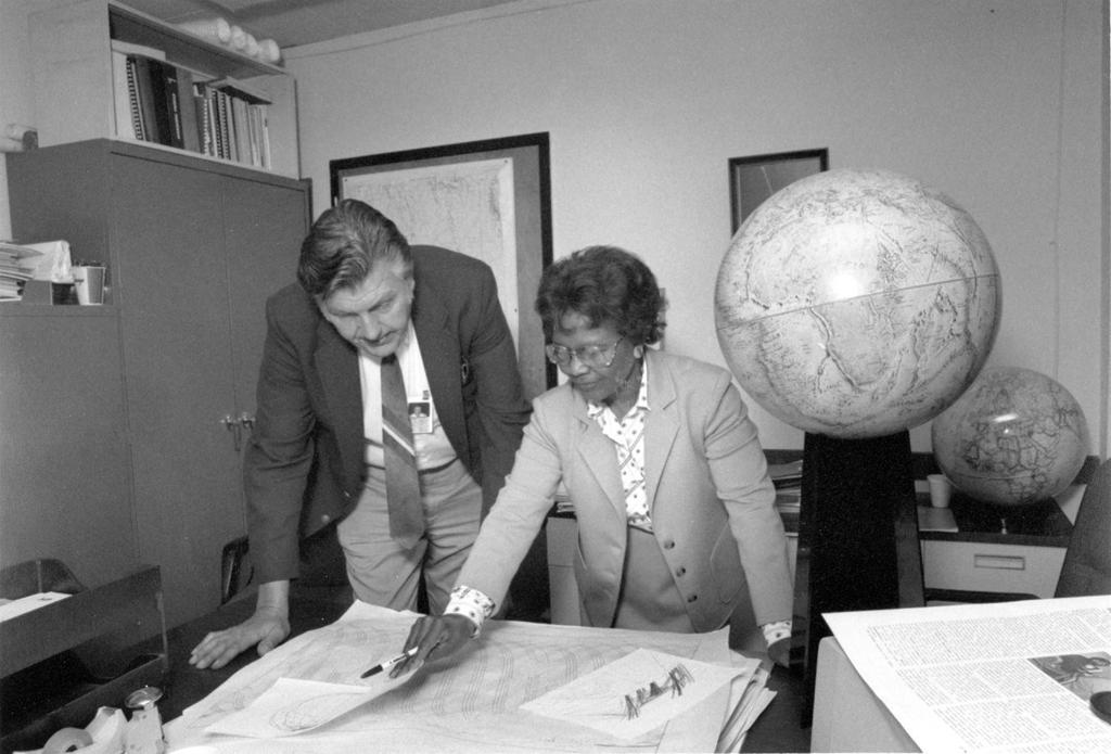
When Dr. West joined the Naval Proving Ground in Dahlgren, Virginia in 1956 as a mathematician and computer programmer, satellite geodesy was in its infancy. The challenge she would tackle throughout the 1970s and 1980s seemed almost impossible: creating precise mathematical models of Earth's shape using satellite data.
Working with an IBM 7030 Stretch computer, Dr. West programmed increasingly sophisticated calculations to define Earth not as a simple sphere, but as an ellipsoid with complex undulations known as the geoid. She analyzed data from NASA's Geodetic Earth Orbiting satellite program and became project manager for the Seasat radar altimetry project, the first satellite capable of remotely sensing Earth's oceans. Her innovative approaches cut processing time in half and set new standards for accuracy.
These weren't just academic exercises. The mathematical models Dr. West created became the essential geodetic framework that made GPS possible. Without accurate models of Earth's shape, satellite positioning systems simply cannot deliver the precision the geospatial industry depends on.
As Captain Godfrey Weekes later noted, Dr. West "worked on the satellite geodesy, and contributed to the accuracy of GPS and the measurement of satellite data." That accuracy, measured in centimeters rather than meters, is what transformed GPS from a military navigation tool into the foundation of a multi-billion dollar geospatial technology industry.
Location intelligence drives business decisions. Smart cities use geospatial data to improve services. Climate scientists track environmental changes with unprecedented precision. None of this would be possible without the mathematical framework that makes accurate satellite positioning possible.
A Difficult Road
Born in rural Virginia in 1930, Dr. West overcame significant barriers to pursue mathematics at a time when both her race and gender made such a path extraordinarily difficult. Yet she persevered, earning degrees from Virginia State University and going on to a distinguished 42-year career at the Naval Surface Warfare Center, retiring in 1998. Her story resonates particularly in an industry still working to improve diversity and inclusion, showing what's possible when talent is recognized and barriers are removed.
In 2021, The Trimble Foundation established scholarship programs at Virginia State University, North Carolina A&T State University, and Florida International University in her name to support students pursuing careers in geospatial technology and engineering. These scholarships ensure that Dr. West's legacy continues through the next generation of innovators who will build on the foundation she created.
As recognition arrived later in her life, Dr. West remained characteristically humble.
"When you're working every day, you're not thinking, 'What impact is this going to have on the world?'" she once said. "You're thinking, 'I've got to get this right.'"
A Lasting Legacy
Today, GPS technology is essential to countless industries that rely on geospatial data: surveying and mapping, construction, agriculture, transportation, emergency response, and so many others. The precision positioning that enables modern smart cities, autonomous vehicles, and infrastructure management exists because Dr. Gladys West had the mathematical brilliance to model our planet with unprecedented accuracy.
The geospatial community has lost one of its greatest pioneers. But her legacy, encoded in the satellites orbiting above us and the positioning systems we rely on daily, will continue guiding us forward for generations to come.
The next time you use GPS coordinates, process lidar data, guide a machine with centimeter accuracy, or marvel at the precision of modern geospatial technology, remember Dr. Gladys West. Remember the mathematician who looked at satellite data and saw not just numbers, but the shape of our planet. Remember the pioneer who transformed how we understand and navigate our world.
P.S. If you want to read more about Gladys’ work and life, I personally recommend picking up a copy of “It Began with a Dream: Dr. Gladys B. West’, her autobiography.