
Blue Marble ‘s Global Mapper v14.2 includes several scripting updates
Blue Marble Geographics has released the latest version of its popular, geospatial information system (GIS) desktop software, calling it ideal for behind-the-scenes processing – from batch data conversion to performing complex extract, transform and load processes such as attribute or geometry merging, clipping or editing.
Global Mapper version 14.2 has several major improvements, the Hallowell, Maine-based company said, including several scripting updates, improved volume measurement tools, a new right-click option to the vector data search dialog, lidar enhancements and many new formats.
“Certainly, we are focused on continuing to expand our support for lidar and more geospatial formats,” said Blue Marble President Patrick Cunningham. “But, this release has some great new scripting capabilities, and we like to remind our users that Global Mapper is a powerful extract, transform and load tool as well.”
Blue Marble’s geospatial data manipulation, visualization and conversion software is used worldwide by GIS analysts in the oil and gas, mining, civil engineering, surveying, and software technology industries, as well as government agencies and university groups.
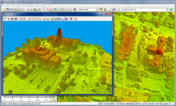
The 14.2 release also includes many lidar enhancements such as search by elevations and the ability to color by return value, which allows users to easily see when there are multiple return values – an ideal feature for performing vegetation analysis.
The new version also introduces support for the new MrSID format files and exporting XYZI (XYZ + Intensity) files, typically from lidar data.
14.2 also allows users to find scripting samples with Global Mapper documentation, including support for calculating attributes, splitting layers, and interactively prompting users for files and folders with the ability to edit and create them in any text editor. Global Mapper workspace files also can be saved as scripts.
The new version also features:
- a new point loading slider bar and reporting tools for point cloud density
- improved import and export options
- support for exporting point clouds to DXF and DWG format files
Blue Marble, a leading developer and provider of software products and services for highly accurate geospatial data conversion, is known for its coordinate conversion and file format expertise – including The Geographic Calculator, GeoCalc SDK, Global Mapper, Global Energy Mapper, and Global Mapper SDK.


