
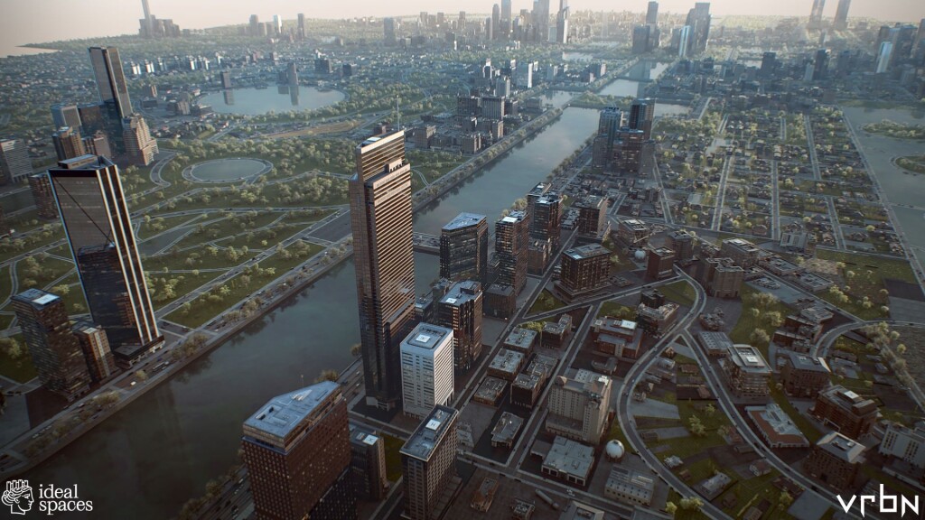
Anca Badut and Ulrich Gehmann built a utopian city. It only took a couple of weeks.
The city was brought to life by advanced 3D visualization and modeling tools, along with a 3D content library, using geographic information system (GIS) technology.
The goal was to create a digital reality that reflected the tradition of utopian architecture, while minimizing the grandiose elements typical of depictions of ideal cities. It had to somehow integrate the elements of European cities that enhance quality of life. Badut and Gehmann called their creation Utopian Disruption, which they presented at Esri’s 2023 Geodesign Summit.
Badut is an architect by training. She works as a technical director at vrbn (pronounced "urban”), a Zurich-based firm that designs detailed computer-generated environments. Vrbn’s clients include video game designers, Hollywood filmmakers, and advertising agencies.
Gehmann, an urban theorist and academic, is the founder and director of Ideal Spaces Working Group (ISWG), a German nonprofit foundation. With an interdisciplinary team that includes engineers, digital modelers, architects, and historians, ISWG conducts research and develops projects that explore how architecture is perceived. The foundation focuses on optimizing the built environment to best serve the needs of people. As ISWG’s manifesto explains, "The ideal space is a mythic theme, but at the same time, very practical.”
Exploring the Concept of Ideal Spaces
ISWG’s most recent exhibition, The Heavenly City and Paradise, displayed at the central church in the German town of Karlsruhe in 2022, foreshadowed Utopian Disruption. Through images and text, it traced the evolution of ideas of paradise, from ancient images to contemporary futurism concepts.
Vrbn and ISWG have had a working relationship since 2015. Vrbn helped build 3D models that were part of ISWG’s display at Biennale Architecture 2016 in Venice, Italy.
Two years later, as part of ISWG’s Artificial Natures exhibition at the Biennale, vrbn constructed multiple interactive 3D models of cities. Some were based on real planning projects, such as Patrick Geddes’s 1935 plan for Tel Aviv, an exemplar of the garden city movement. Others were imagined or imaginary. These included Sforzinda, a never-realized Renaissance utopian city imagined by Italian architect Filarete in the 15th century.
Matthias Buehler, vrbn’s founder and chief technology officer, had studied the architecture of favelas, knowledge he used to begin constructing the 3D model in 2012. This initial project, done in collaboration with Cyrill Oberhaensli (now the software developer lead at vrbn), began as a hobbyist project, a way to test and showcase the technical capabilities of ArcGIS CityEngine. As with all vrbn work, the visualizations reflect an attention to realism, achieving a lived-in look rather than the typical gleaming architectural renders made by most firms.
In 2015, an ISWG member learned of the project and asked Buehler if parts could be repurposed for the group’s 2016 Biennale exhibition project. The idea was for the favela model to serve as a counterpoint to the other examples on display, which followed more conventional models of ideal worlds. It facilitated a deeper discussion of the urban and spatial qualities of ideal worlds, a core focus of ISWG.
The dialog helped Buehler realize that although favelas embody spatial chaos, they also reveal something profound about modern cities.
"A favela certainly doesn’t provide anything close to ideal living conditions, of course, but there are certain interesting spatial qualities of its urban fabric that modern cities lack or have lost over time,” Buehler said. "Having seen a favela myself, I know that people who live there have a strong influence on the design, function, and construction of their spaces. You can interact in these spaces socially and develop connections with your neighbors and the community. In the Global North, building codes and regulations often make that virtually impossible.”
Applying these concepts to a modern utopian ideal became a driving force of the Utopian Disruption project. "Since the dawn of time, deep connections in communities have been an essential aspect of supporting meaningful social life, a sense of place, and a kind of spiritual home,” Buehler said.
Buehler offered a comparison with Brasilia, Brazil’s capital city. Built according to a master plan between 1956 and 1960, Brasilia has since become an urban planning cautionary tale.
"Brasilia was designed as an ideal city, and it is ideal in the geometric sense,” Buehler said. "It has broad highways that reflect a transport-centric philosophy, but with too little thought on social space for actual living. Brasilia was designed more like a sculpture. It’s not a truly livable space if function follows form and the form is unchangeable.”
Buehler proposed the Ideal City project to Gehmann, as a way to collaborate again and explore these concepts. Although Buehler did not have time to devote himself personally to the project, he deputized Badut to be vrbn’s representative.
Modeling Tools Bring Ideas to Life
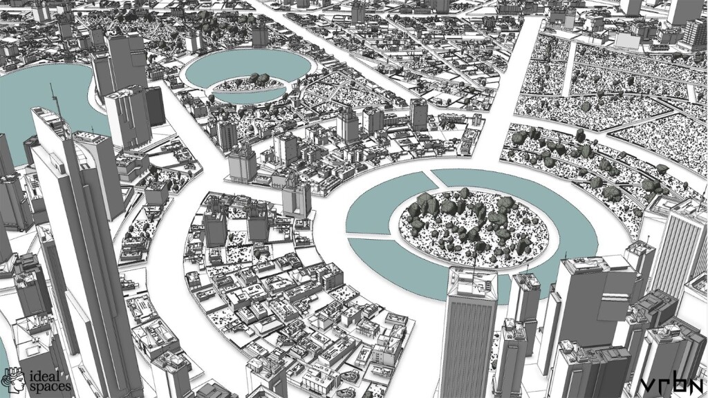
One of the primary tools Badut used to create Utopian Disruption is ArcGIS CityEngine, advanced 3D modeling software for massive, interactive, and immersive urban environments. Urban planners and architects use CityEngine for realistic visualizations of their projects.
Badut had first encountered the tool during her studies at Ion Mincu University of Architecture and Urban Planning in Romania, where she used it as a way to examine real spaces. "So I already knew that it’s a super powerful tool, not only for doing a conceptual project from scratch, but also for analyzing existing areas of a city,” she said.
CityEngine employs an approach that makes the challenge of creating an entire realistic city more manageable. It involves a set of rules that can be applied and easily altered for individual sites or across whole landscapes.
The basic dimensions of one building or street, for example, can form a template for others. Parameters of one element, such as curb heights or centerlines, can be tweaked to make another one rather than starting from scratch. Small differences in a facade, such as windows with sashes or without, can all be modified together to save time. Using such procedural rules and tapping into a large internal library, vrbn can create many variations to avoid cookie-cutter sameness, while keeping control on design for very large areas.
As an engineer, Buehler had helped build early versions of ArcGIS CityEngine. He felt the time was right to push the tools and internal production workflows toward a utopian direction.
"At vrbn, the tools we use to create our 3D visualizations had progressed far enough that we could do one of those collaborative projects relatively efficiently,” he said.
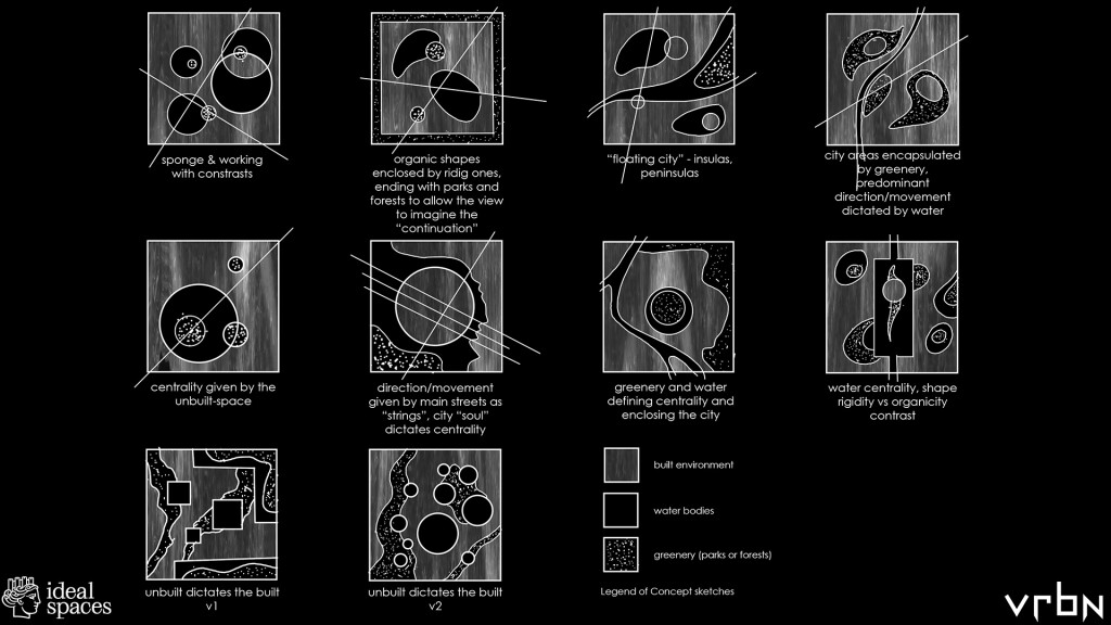
What most intrigued Badut about the project was the chance to diverge from "the old way of designing a utopian or ideal city, in which everything would have a kind of opulent vibe, with lots of piazzas and super intricate buildings,” she said.
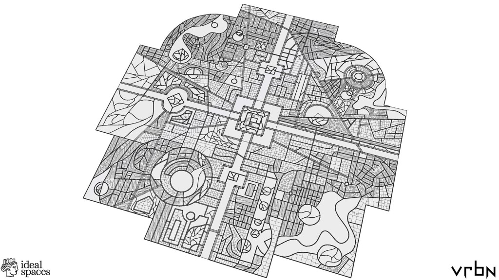
Utopian Disruption shares some characteristics with classic approaches to utopian cities. Like Sforzinda, it has a geometric symmetry with an emphasis on waterways. In
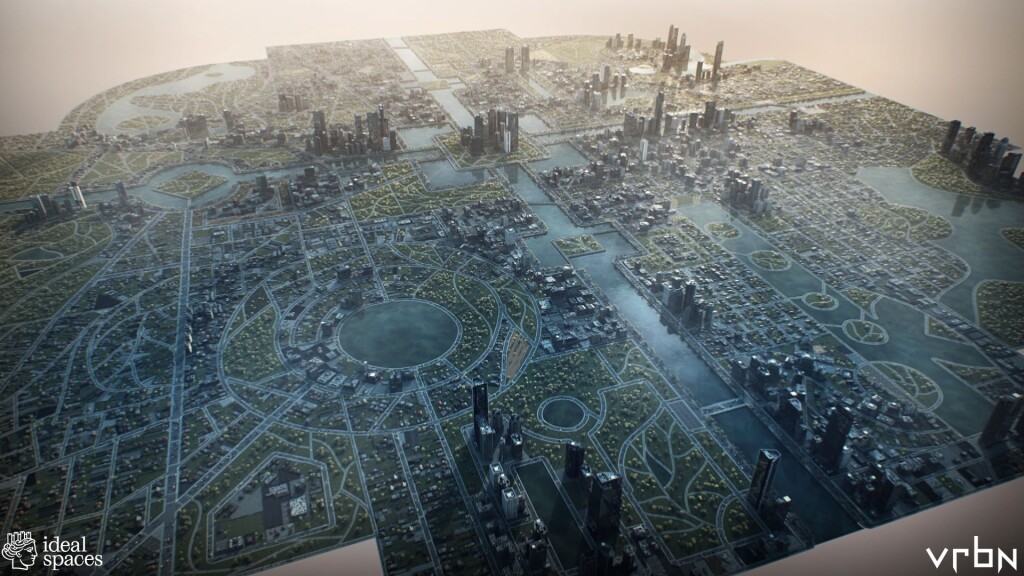
There is a futuristic quality to Utopian Disruption, an almost mythic, garden-like quality. At the same time, it looks like a city, with skyscrapers and parks and recognizable infrastructure. One of the project’s guiding principles was to avoid using architectural styles, such as baroque, that have historically been used to depict utopian cities throughout history.
"It’s not about luxurious spaces or castles or fountains,” Badut said. "It was more like we wanted to use contemporary and affordable architecture that people can interact with, including beautiful public spaces, parks, and waterways. It’s very conceptual, but when you look at the buildings and how they’re placed next to one another, it’s basically North American-inspired architecture. We wanted to take what’s existing, yet propose a design approach that could scale from very small plot-scale interventions to vast cities.”
The team also didn’t hold back on one of its strengths: realistic visualization.
Buehler hopes Utopian Disruption will inspire professional urban planners to plan ideal cities, despite the inherent limitations of contemporary construction principles. These cities would stress the inclusion of public space, parks, and other places where nature and culture meet.
Ideal Futures in the Present
Utopian Disruption is not a detailed blueprint of a city. It doesn’t confront the gritty planning realities of sprawl, traffic, walkability, and pollution. Yet, it’s not obsessively ideal. Instead it shows what can be achieved in reality.
"It’s not just aqueducts and green ponds and lush gardens,” Buehler said. "Reality is a bit messier, and it’s OK to see industrial infrastructure. But if we could just push ourselves a little, we could do this.”
Badut and Gehmann were careful to make the ultimate borders of the city invisible, something for the reader to fill in. Badut compares it to a puzzle piece, a place in flux where the viewer can imagine how the city might expand, perhaps eventually meshing with similar cities. "A boundary is no sharp line, but a transition zone where something different begins,” she wrote.
This echoes the democratic ideal Buehler noticed in favelas, where the lack of rigid urban planning gives residents an opportunity to sculpt their neighborhood’s contours.
"This idea of letting a story have an impact on the viewer was really important to me, which is why I didn’t want to have any boundaries,” Badut said. "So it wasn’t only about making it beautiful or functional. It was also about what stories the viewer can generate. It can be like a book without an ending.”
Learn more about the advanced tools that are being applied to smart city planning.
This article originally appeared at Esri Blog.


