
The Overture Maps Foundation, a community-driven effort to develop an open map dataset built for map service providers, last month announced the first public showing of their work in what they are referring to as a “pre-release.” The Overture Maps Foundation was officially formed last December in an effort headed by the Linux Foundation with Amazon Web Services, Meta, Microsoft, and TomTom as the group’s founding members. Esri has also since joined as a general member, with Cyient, Precisely, PTV Group, and SafeGraph joining as contributor members.
The foundation is being very clear in their announcement of the release, noting that this is simply a way to be transparent about what they are working on while giving the ability for stakeholders to present feedback. In the release they note that this is not a final dataset, but a “showcase of what we plan to build,” continuing that this initial dataset is “not intended for production use.”
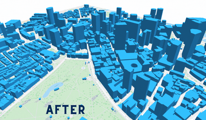
That said, there is plenty to dig into on the part of the map service providers, with three main highlights provided by the Overture Maps Foundation in their release. Firstly, they point to the “collaboratively-built map data,” noting that the dataset includes the addition of over six million building heights located in about 34,000 square miles in cities such as Boston, Chicago, and Santa Clara. To develop this data, the foundation utilized the USGS 3D Elevation Program (3DEP) lidar data for the terrain model. From there, they cross-checked the data with building footprints from OpenStreetMap, the Microsoft open building footprint data, and community sources to see where elevation gain was really a building.
They also note that the foundation is looking to utilize a variety of open map data sources. OpenStreetMap is, of course, an extremely valuable resource for this data, and the Overture Maps Foundation does indicate that they are “leaning heavily” on data from OSM. That said, they’re also adding open data from Microsoft ML buildings, mentioned above, and “additional area translations.”
Finally, the foundation emphasized the quality checks that went into creating this datasets. They say they “put the data through multiple validation checks to find as many of these problems as we can: broken data, bad words, vandalism, etc.” Similar to how they are framing this dataset in general, they note that this checking is still a developing process, with the goal of building “commercial-grade quality.”
Transparency is clearly a goal for the foundation in general, and is the basis of this release, in addition to seeking feedback to continue iterating their datasets. With that in mind, they also shared some of their future goals alongside what is included in this pre-release. Those goals include improving quality check processes, but aren’t limited to that. They also are looking to expand their building footprint data to cover most of the United States in future releases.
More broadly, the foundation is also looking to make maps easier to use. They note that they’re “working to design a common, well-structured data schema,” with designs being shared in the coming weeks and data in the new structure coming out later in the summer. Furthermore, they are also working on a system that will link entities from different datasets to the same real-world entities to simplify the merging and combining of data, with a similar release cadence to the one discussed above.
Reliable map data has always been incredibly important, and that utility is only growing in recent years with the advent of technologies like autonomous vehicles and the promise of things like a “metaverse,” where this type of geospatial industry will, in theory, be crucial. In order to meet this growing demand – and not just the demand for the maps themselves, but quality map data – it’s imperative that there is cooperation between private companies as well as between public and private entities. The Overture Maps Foundation is looking to be the facilitator of this collaboration by promoting open standards and developing the datasets from these combinations, making them available to anyone who can benefit.
This is not an easy task, something which the foundation acknowledges. They say, “We’re just starting. This is a long, complex road with a lot of challenges ahead. But we are excited about the team that is coming together. The more we work together on this, the bigger the vision becomes. Ultimately, our goal is to build open map data that anyone can use. We think that will massively expand the use of location as a critical part of the world’s shared infrastructure.”
The Overture Maps Foundation encourages anyone with interest for more information or feedback to reach out. The pre-release files and notes can be found here.


