
3D Laser Mapping is leading distributor of TerraScan software
3D Laser Mapping said Tuesday it has supplied software to accurately create 3D terrain models from millions of individual laser scanned measurements to help protect the beaches of Sussex on the south coast of England.
Based in Nottingham, U.K., 3D Laser Mapping integrates laser scanning hardware with software and peripherals for applications in coastal mapping, mining and manufacturing.
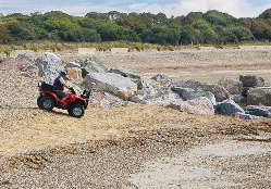
Two West Sussex district councils – Adur District Council and Worthing Borough Council, which merged services in 2007, regularly survey the beaches between Selsey Bill and Rye Harbour by collecting data from a mobile laser mapping system mounted on an all-terrain vehicle for their regional coastal monitoring program.
The councils purchased TerraScan software, developed by Finland-based TerraSolid, from 3D Laser Mapping, a leading distributor of the software, to identify and classify point classes like ground, vegetation and buildings from the data measurements.
TerraScan processes the data into 3D terrain models, which is submitted to the Channel Coast Observatory, where it is made available to other regulatory and conservation groups.
“The TerraScan software purchased from 3D Laser Mapping will allow us to format, edit and classify our laser scanned data in an efficient and consistent manner,” said Dan Amos, project manager of the coastal monitoring program. “We can now create TerraScan projects within [Autodesk’s] MicroStation and, using pre-defined macros, classify and export ground points for onward processing and creation of our deliverables.”
3D Laser Mapping also provided onsite training to end users at the Adur and Worthing councils.


