
A murder scene, an auto accident, a collapsed building, a dilapidated stairway where a fall led to severe injury – Paul Francis has used laser scanning to document these and other scenes for forensic investigation and analysis. Last week we looked at how Francis and his team at Northway-Photomap Inc., Toronto, prepare for the scene visit, then go to the scene and capture it. This week follows the team through the rest of the process: assembling and analyzing the data, preparing and presenting final deliverables, and waiting for possible follow-up requests.
Data analysis
The first step in data analysis is to assemble the data from the firm’s Optech ILRIS-3D scanner into a virtual scene. Northway-Photomap aligns and merges data from multiple scans using InnovMetric Software‘s PolyWorks. “In our police-sanctioned forensic work, the formation of a single virtual scene is the current final product,” Francis reports.
But forensic projects are not always associated with police work. “We have numerous clients who are forensic engineers or insurance companies,” according to Francis. “These are projects where the analysis of the data can become our work. Determination of slopes – on sidewalks, pool slides or roads – can be work brought back to your office.” PolyWorks can be used to create PowerPoint presentations, AVI files, or more detailed analyses of the scan data – this varies according to the kind of project.
In traffic accidents, the depth of impact – the degree of vehicle deformation – indicates impact speed, and is a parameter needed for accident recreation. Also, Francis reports, “We have found that most policing agencies work in 2D – they want a single 2D line showing the outline of the vehicle.” Adding the third dimension “allows for much more in-depth analysis” but often is not requested – “an open door for scanner operators,” Francis believes. “When you start making deliveries to them, you have to go in and work with them to understand what [information]they’re taking from an accident scene.”
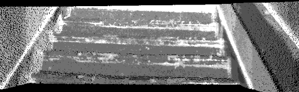
In one project Northway-Photomap scanned a set of stairs after an individual fell down them and become a quadriplegic. The client wanted the scene documented because the stairs were going to be torn out. “The stairs weren’t in good shape – they were crooked, angled, and it was difficult for us to walk up them when we got to the scene.” On the scene it occurred to the team to scan not just the stairs, but also how they behaved in use. “We scanned the stairs with no one on them, then we scanned them a second time with a 225-pound volunteer” standing on the treads. Processing the data in PolyWorks allowed Francis to show how far each tread flexed under load. “This was possible because the operator knew the ability of the software and hardware, and applied it to the situation on the scene.”
Again, “this portion of the project is not defined until you arrive on the scene, with your knowledge of your system, and become a consultant to the client,” Francis advises. “If this is a new client, make sure you keep them informed on the future uses you can see for the data.” geovisit();
Creating final deliverables
The initial deliverable is presented to the client immediately on completion of data capture. Final products are delivered after much discussion with the client. “In some cases, knowing that you have the data is sufficient, and we are not called on again,” according to Francis. “However, in other cases the final product is something needed for a courtroom, and often that product is much different than anticipated.”
Within one week of data capture, Northway-Photomap delivers a project methodology, presentations of each individual scan, and a virtual site tour of the data captured. The methodology, typically presented in PowerPoint, includes an explanation of the technology and how the system works. “Remember that the client who hired you for the project understands the technology, but others viewing the data may need a layman’s understanding.”
The PowerPoint file also presents each individual scan completed. “We take this opportunity to expand upon the uses of the scan data in an attempt to further develop the market,” Francis notes. “Some scans are shown as simple grayscale point clouds, some as color point clouds, and some after being processed into a solid model format.”
A high-impact way to present data to juries is 3D physical models created with rapid prototyping. “Any evidence entered into a court must be able to go to the jury room for further examination,” Francis explains. “Say you’ve presented a project using special software to manipulate the 3D data – you need an operator who can do that. But you can’t send the operator into the jury room. So we’ve created physical models that can go right into the jury room. Jurors can look at the model, see the detail, for example how the car wrapped itself around the pole.” In one case, the collapse of Toronto’s Uptown Theatre, the physical model is being used in the coroner’s inquest. [See images in last week’s issue.] Northway-Photomap uses a Z Corporation rapid prototyping system to produce these models.
Last, “we present the final virtual tour of the site, allowing all the scans to be viewed at the same time. This deliverable is typically passed throughout the organization, and is viewed by many more than anticipated.” Often this presentation or some variation is the final deliverable.
Wait period
Police work involves a lot of “hurry up and wait,” according to Francis. “So you capture the data, you deliver it, and if they need anything else you’ll get a call. You may get called to court; you may not.” In fact Northway-Photomap has yet to present its scan data in a courtroom, Francis reports. In several civil cases its data was used to help reach out-of-court settlements – some were settled “due to the existence of our scanned data, and the overwhelming graphical presentation that scanned data provides.” Meanwhile, in the three murder cases it’s been involved in so far, some have not yet reached court while in others the accused pled guilty. The firm is confident that “one day we will take our data to court and prove its reliability and accuracy.” Francis sums up, “They’re using lasers to catch people speeding. I take that as acceptance of the technology – in essence we’ve just added a couple of mirrors.”
Northway-Photomap normally works on a lump-sum basis for projects quoted in advance. “But if they call us and say, ‘We need you here right now,'” both data collection and post-processing are provided at an hourly rate. geovisit();


