

Contributed by Dr. Frank de Morsier, COO and Co-Founder of Picterra
As we navigate the rapidly evolving landscape of geospatial technology, a crucial challenge emerges: the growing skill gap in the Geographic Information Systems (GIS) industry. This gap is not just a hurdle; it represents a significant opportunity for innovation and adaptation. At Picterra, we've been closely attuned to this challenge, recognising the need for tools and solutions that not only embrace technological advancements but also make them accessible and usable for professionals across various sectors.
This skill gap in the GIS industry is not just a matter of academic interest; it's a practical challenge that affects how effectively we can harness the power of geospatial data. As someone who has transitioned from an academic background in electrical engineering, information technology, and remote sensing imagery to the practical world of GeoAI, I understand the importance of bridging this gap. It's not just about developing new technologies; it's about making these technologies intuitive and accessible to a broader range of professionals.
In addressing the challenges of the geospatial industry, the focus extends beyond creating advanced tools; it's about equipping professionals with the necessary skills to effectively leverage these tools. This approach is not unique to any single entity but reflects a broader industry trend towards collective innovation and responsiveness to the demand for user-friendly and powerful geospatial analysis tools.
As we delve into this theme, we explore the various ways the industry is contributing to narrowing the skill gap and shaping the future of geospatial technology. The emphasis is on a collective effort, where different players, including companies, academic institutions, and individual professionals, are all playing pivotal roles in this evolution.
Revolutionising GeoAI with zero code solutions
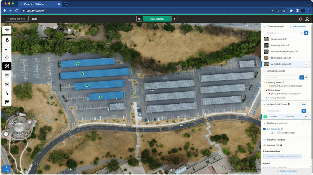
The integration of advanced technologies like Meta AI’s Segment Anything Model (SAM) into zero code platforms is a prime example of how the geospatial industry is evolving to meet the needs of a diverse user base. This innovative approach allows users to apply a 'magic wand' to any object in an image, easily segmenting it out for AI model training. Leveraging deep learning, the integration of SAM facilitates an intuitive interaction with imagery data, making complex tasks more accessible.
This development is particularly significant as it simplifies one of the most complex aspects of AI model training – the annotation and segmentation of images. Traditionally, this process requires extensive expertise and time investment. However, the integration of such models into zero code platforms transforms it into a task that can be accomplished quickly and efficiently, even by those without coding knowledge. This not only accelerates the model training process but also democratises the development of custom AI solutions in geospatial analysis.
The broader implication of incorporating such advanced technologies into user-friendly platforms is the empowerment of a wider range of users to harness the full potential of AI in geospatial analysis. This trend is a critical step forward in the industry's mission to make complex geospatial data analysis more accessible, enabling a diverse group of professionals to contribute to and benefit from the advancements in GeoAI.
Addressing the industry's skill gap
The geospatial industry is witnessing a significant transformation, driven by rapid advancements in technology. However, this progress brings to light a critical challenge – the skill gap. Professionals in the field often find that their traditional skill sets do not fully align with the evolving demands of advanced geospatial technology. This disparity is not just an obstacle; it's an opportunity to rethink and reshape our approach to education and skill development in the field.
As someone deeply immersed in the world of GeoAI, I've observed a growing need for a more inclusive approach to technology deployment. The focus shouldn’t solely be on creating more advanced tools; it's equally important to ensure these tools are accessible to a diverse range of users. This perspective is crucial in an industry where the application of geospatial analysis is expanding into increasingly varied fields.
In response to this, the industry is seeing a shift towards more user-friendly platforms. The goal is to lower the barrier to entry, enabling professionals from various sectors to leverage geospatial data without needing extensive training in coding or data science. This approach is pivotal in democratising geospatial technology, ensuring it’s not just a tool for the few but a resource accessible to many.
Recognising the importance of this shift towards more user-centric solutions, there is a growing emphasis within the industry on simplifying the use of geospatial platforms. This trend is not confined to any single entity but is a collective movement aimed at making advanced geospatial tools more accessible and intuitive for a wider audience.
Ultimately, addressing the skill gap is not just about filling vacancies or teaching new software. It’s about fostering a culture of continuous learning and adaptability, ensuring that as the geospatial field evolves, so does its workforce.
Customer-centric innovations and success stories
The geospatial industry's efforts to bridge the skill gap have been significantly enriched by customer-centric collaborations. These partnerships provide valuable insights into overcoming skill-related challenges, enhancing the collective approach to GeoAI solutions.
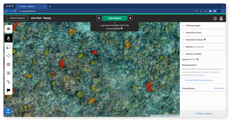
A key example is the collaboration with The Nature Conservancy in coral mapping. This project underscores the impact of intuitive technology on environmental conservation. By simplifying complex geospatial tasks, The Nature Conservancy can focus more on conservation goals rather than the technical aspects of data analysis, demonstrating how tailored GeoAI solutions can empower mission-driven organisations.
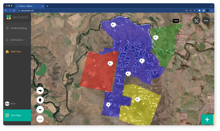
These partnerships with The Nature Conservancy, Cyient, and Sensand are examples of how the industry is learning and evolving. They highlight the need for technology that is not only advanced but also adaptable, accessible, and user-friendly, ensuring a wide range of professionals can effectively utilise these tools to overcome skill-related challenges and achieve their objectives efficiently.
Conclusion
Reflecting on the collective journey in the GeoAI landscape, several key insights emerge, offering guidance for the industry's evolution. These learnings are pivotal for navigating the dynamic field of GeoAI, pointing toward future developments and strategies.
The commitment within the industry to this promising future is strong. Continuous innovation and adaptation will be essential to ensure that geospatial platforms and services not only meet the current demands of the industry but also anticipate and address future needs. The focus will be on empowering users with the tools and knowledge they need to effectively harness the power of GeoAI, ushering in a new era of geospatial intelligence.
 Dr. Frank de Morsier, COO and Co-Founder of Picterra, holds a BSc in Electrical Engineering, an MSc in Information Technology, and a Ph.D. in remote sensing imagery from EPFL, Switzerland. With a background in remote sensing image processing since 2014, he is an expert in AI and pattern recognition for image processing. Additionally, he teaches at EPFL and UNIL, focusing on image processing for earth observation. At Picterra, he is dedicated to enhancing internal processes and developing AI algorithms for extracting geospatial information from various images.

.jpg.small.400x400.jpg)