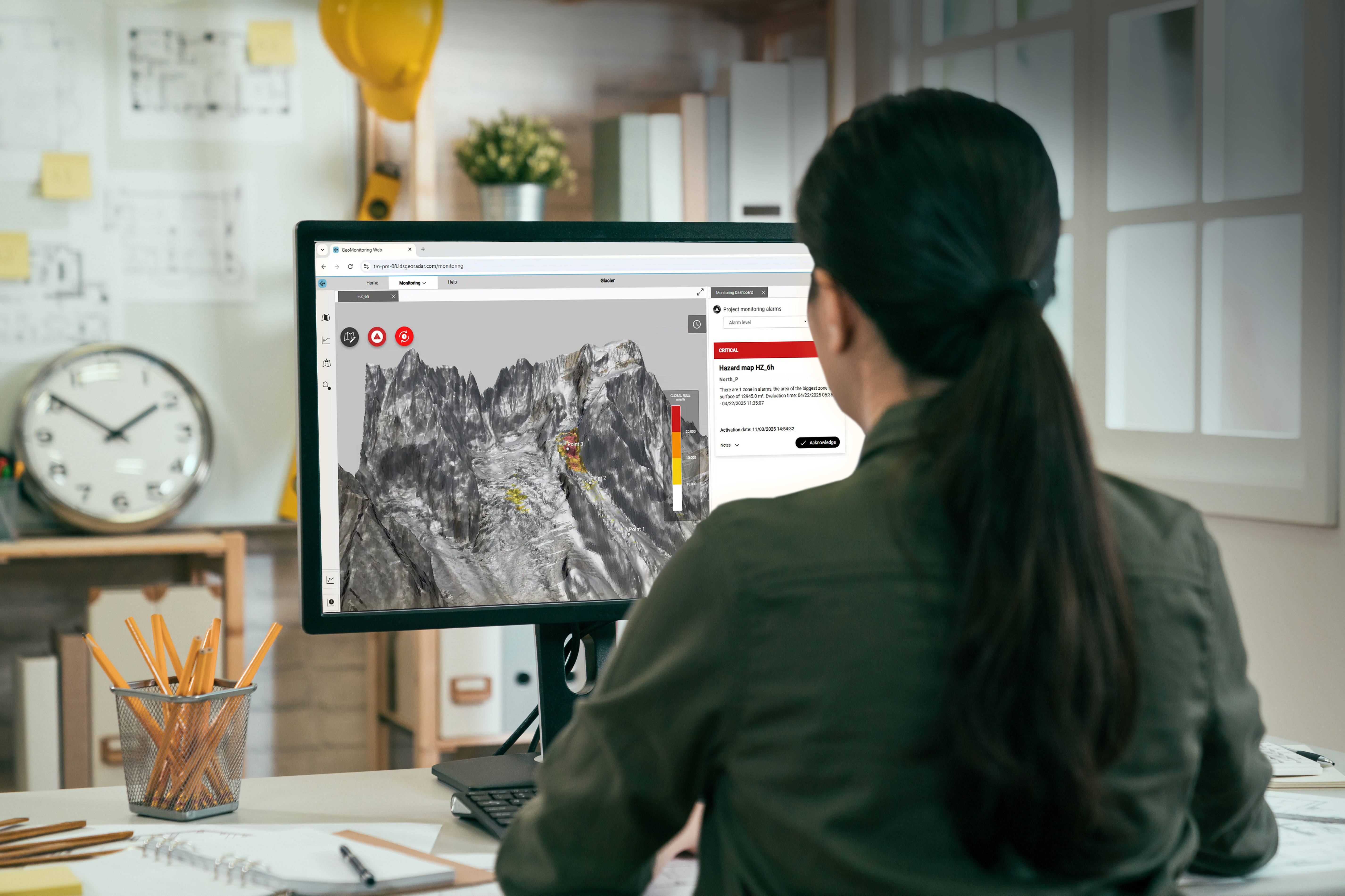
Hexagon’s new GeoMonitoring web platform’s visualization and analysis tools delivers actionable insights for early safety interventions that protect people and high-value assets. It does this by combining visualization, analysis and alerting within a single 3D monitoring environment: its realistic 3D visualization allows users to directly correlate real-world conditions with measurements that indicate ground instability.
Fast access to data is critical in natural hazard and mining environments, where speed directly supports risk mitigation and decision-making. The platform has been designed to ensure that new data is automatically collected, processed, and made available to users with minimal delay. Data is automatically processed in real time in the field: thanks to reduced data size and the use of a single transmission channel, communication between radar and the GeoMonitoring platform remains fast and reliable while minimizing complexity, latency, interference, and potential points of failure.
Data assessment
Through fast, interactive analysis of points and areas derived from the 3D model, users can assess how measurements evolve over time and compare multiple areas and data types, such as displacement, velocity, acceleration, and inverse velocity within a single chart. Advanced alert configuration tools combine spatial and temporal measurements to generate hazard maps that show risk levels by area and automatically trigger alerts based on user-defined criteria, enhancing safety by enabling earlier intervention.
The user only needs to pair the radar sensor with the server once; after that, data transfer is fully automated and effortless. This approach will be extended to all Hexagon technologies, while for third-party solutions, data collection will occur through software APIs where available or via automated CSV file import procedures. Once collected by the GeoMonitoring server, the data is immediately ready for visualization, analysis, and alerting.
GeoMonitoring’s collaborative analysis tools
The GeoMonitoring platform supports multiple user profiles with different privilege levels, allowing clear separation between users responsible for system management and configuration and those more focused on reviewing the data and current site conditions. Multiple users can interact with the same dataset simultaneously without interference, and actions are tracked and can be audited.
For easy collaboration and clear project management, charts, visualizations, and preconfigured dashboards are shared across users, summarizing project status and active alarms. Advanced alarm management features mean any changes to alarm settings trigger notification warnings, as well as sending comments and actions on activated alarms, ensuring efficient collaboration and fast response.
TARP procedures integration
For both natural hazards and open-pit mining, ground instability management typically involves a Triggered Actions Response Plan (TARP). This plan defines several hazard levels (usually 3–4), the conditions for transitioning between levels, and the actions associated with each level. GeoMonitoring’s alerting system is designed to seamlessly integrate with TARP procedures. It allows users to configure the number and names of hazard levels and link specific actions to each level. All alarm configurations are based on user-defined thresholds that determine when a transition from one level to another occurs.
When an alarm level is triggered, GeoMonitoring automatically notifies the responsible personnel via the user interface and through email. Recipients can access the GeoMonitoring web application, review the data to validate the alert, and implement the actions defined in the TARP.
Mastering the full monitoring cycle
Data aggregation and visualization are only the starting point for GeoMonitoring. The platform is being developed to support the full ground stability monitoring cycle, from data acquisition through to analysis, decision-making, and response. Initial development focuses on streamlining data collection and visualization across multiple monitoring technologies to improve efficiency and ease of use. This is complemented by advanced analysis and alerting tools that enable timely, informed decisions in safety-critical environments.
Over time, GeoMonitoring will integrate monitoring data with geological and geotechnical information, making it easier to correlate measurements with ground conditions and better understand observed behavior. Further enhancements will introduce AI-driven analytics and data fusion techniques to generate more insights and help anticipate potentially hazardous conditions earlier. The platform aims to close the loop with geotechnical simulation software, using monitoring data to build accurate simulation models and results to help predict future areas of concern.