

Generally speaking, we see the development of all sorts of technology coming through incrementally, at least in terms of who is using it. That process typically starts with the most technical users, with accessibility increasing for “non-technical” users as time moves along. We’re seeing that today with geospatial technology, particularly the software with which people can view and gain insights from data. The big, modern frontier is easily getting that data into the hands of every stakeholder who can make use of it, regardless of technical acumen. This process is often easier said than done, as these datasets are traditionally too large for normal, consumer-grade computers, to say nothing of the technical knowledge needed to fully utilize most tools that have been on the market.
One of the companies looking to solve for these problems, particularly around large and diverse geospatial datasets, is METAGEO, which earlier this month launched their open beta. Paul Spaur, the founder and CEO of the company, took some time to speak with Geo Week News about his new platform and what it can add for its users.
Broadly speaking, Spaur envisions this product being used by a number of different types of professionals, and even hobbyists, for myriad use cases. This idea is reflected by the tiers being offered for the product. Specifically, there are free tiers available for personal and educational use – the latter allowing for ten gigabytes of space compared to two for the former, and available to those with an email address ending with ".edu" – along with paid levels for personal, commercial, and enterprise users. Spaur also indicates that there will be a tier for classroom licenses coming in the future, too.
Streaming Geospatial Data
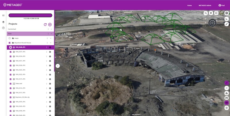
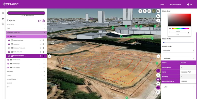
In Spaur’s words, METAGEO is an “easy-to-use web GIS platform which allows users to upload many different types of files,” and it is delivered in a format similar to that of Google Earth. As he describes, one of the pain points involved with geospatial data is that it comes in many different file formats, and oftentimes each requires a different software. With this platform, Spaur explains, they “bring all this different geolocated data into one space, and we make it streamable.”
That data includes both data captured by individual users being imported into the platform as well as a selection of freely and publicly available larger-scale GIS data. During a live demonstration for Geo Week News, Spaur said, “We are building an open source data library where people will be able to bring in open source data from different sources, because a lot of folks don’t realize that there’s a lot of data out there publicly. So we want to be able to connect people with that data.
It’s that concept of being “streamable” which Spaur sees as powering METAGEO’s ability to not only incorporate all of this different data layered upon itself in the platform, but also having that data be easily shareable to any internet-enabled device, including computers, mobile devices, AR and VR devices, and even metaverse platforms down the road. He compares it to how watching videos online has evolved over the years. “Back in the 90s, if you wanted to watch a video, you had to download the entire video. Now, we have streaming capabilities so you can skip to exactly what you want without downloading the entire file,” Spaur said. “So, we’re doing that with geospatial data.”
Solving real-world problems
In developing any new technological solution like this one, the obvious goal is to be solving real problems being experienced by some group of people. As Spaur sees it, METAGEO works to solve three main problems. The first is around the sharing of large amounts of data as discussed above. He notes that many people are relying on things like Dropbox to share files, but METAGEO allows that sharing to happen in real-time within the platform. There’s also simply the ability to access the data, harkening back to the free, publicly available data mentioned above. Spaur says METAGEO includes a library of some of these datasets available to everyone.
And finally, the platform should improve accessibility, both in terms of that data sharing between stakeholders as well as just using it. Spaur says, “We want to have a no-training approach where you can just pick it up and intuitively understand how to use it.” That, of course, is key to getting some of the non-technical stakeholders on board.
In terms of those stakeholders who will benefit, we asked Spaur who exactly he sees as being the beneficiary of the platform within an organization. As he envisions it, METAGEO will be “something that the technical folks will manage, like they currently do, but then everybody from the C-Suite down to the boots on the ground will be able to utilize the data.” Focusing largely on AEC, public safety, and government organizations, with everyone being able to provide live updates within the app. This, in turn, better enables that key communication between those in the field and those in the office – again, both technical and non-technical – which in theory should lead to more efficient project management and fewer costly delays.
While METAGEO is now entering its open beta, the platform has been in closed beta for a selection of users for a little over a year, and Spaur was able to share one success story he’s already seen using the software. He was unable to go into too many specifics, but a small nation was using the platform and had fears that illegal deforestation was taking place within its borders. The suspected area of deforestation was too large to fully cover with a simple drone map, so they flew several drones over the area. Using METAGEO, they were able to overlay these several drone maps over each other to create one large map, and they could accurately measure the amount of acreage from these deforestation activities. This kind of crucial work, requiring massive amounts of data, would have been overly cumbersome without this kind of tool, and it’s likely the extent of this deforestation activity wouldn’t have been discovered.
Looking to the future
We’ve talked a bit about the current capabilities of METAGEO and the broad problems which can currently be addressed by the platform, but Spaur also has plenty of future-looking ideas as he sees the use cases for geospatial data in the consumer and entertainment realm to be an untapped market. Specifically, he’s looking ahead to potential applications within the metaverse.
Obviously there is still a lot up in the air as to what the metaverse will even look like, but we’ve discussed how the geospatial industry will theoretically play a big role in its development. Here, Spaur mentions links between METAGEO and both the Unreal and Unity engines, both of which figure to be major players in the metaverse ecosystem. Asked about the idea of separate metaverses for industrial and consumers, Spaur says he envisions multiple “purpose-built” metaverse platforms.
It’s not hard to see how METAGEO can fit for enterprise companies working on large projects with the sharing capabilities discussed above. On the consumer side, Spaur makes a few different points. One is that he has some experience developing geospatial tools for consumers, creating immersive experiences for past Olympics. He also notes that, since METAGEO can be used on any internet-enabled device, the models can easily be viewed within virtual reality devices.
He points to Roblox as a platform which has built up a strong consumer metaverse platform, and notes that he can envision users wanting to put their own neighborhood into a video game they’re developing, or wanting to drop photos and/or 3D scans into a map, something that is already available within the platform. It’s still largely a mystery as to how the metaverse will shake out, particularly on the consumer side, but it’s clear Spaur sees geospatial being a big part of that, and is setting METAGEO up to be a key piece in bridging together those worlds.


