
CyberCity 3D, a leading provider of advanced geospatial smart building data, has teamed with UK-based aerial mapping company Bluesky to create smart 3D city models throughout the UK. The Company also plans to integrate Bluesky’s National Tree Map into
CyberCity 3D, Inc., a leading provider of advanced geospatial smart building data, has teamed with Bluesky International Ltd, a UK-based aerial mapping company, to create cutting-edge, 3D city models.
This collaboration will bring unparalleled 3D models to the UK and beyond by combining CyberCity 3D’s proprietary 3D building production with Bluesky’s stereo aerial imagery. Access to Bluesky’s massive data library, covering 150,000 sq km of off-the-shelf aerial photography, allows CyberCity 3D to gain access to urban centers across the UK immediately for 3D Smart Building production. In addition, Bluesky’s specialization in the acquisition and processing of aerial photography is a perfect fit for CyberCity 3D as it finds the need for “new” flights to produce 3D models for its increasing client base.
“Bluesky is very excited to be working with CyberCity 3D to service the ever-growing market for 3D content in the UK. Their innovative approach to delivering 3D models will revolutionize the way in which users select, order and use 3D content for a wide range of applications,” stated Ralph Coleman, Bluesky Sales Director.
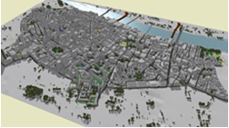
Earlier this year, CyberCity 3D—utilizing Vertex imagery– completed production of 3D London City Centre as well as an extended area including Nine Elms, South Kensington, and Chelsea. The resulting 3D model has attained acclaim and client interest, and led to this groundbreaking new agreement with Bluesky. By the end of the summer, this data partnership is expected to grow into a 3D data sales agreement involving maps throughout Great Britain.
“This alliance provides CyberCity 3D with the opportunity to offer precision 3D smart buildings in Great Britain, equipping our clients with unparalleled 3D city modeling. We’re thrilled to enjoy access to Bluesky’s impressive data library for immediate use, and look forward to working with the company as our clients’ require production in “new” flight areas of the UK,” declared Kevin DeVito, CyberCity 3D CEO and founder.
CyberCity 3D and Bluesky concentrate in areas of mutual interest including solar and other “green” markets in addition to their synchronicity with stereo aerial imagery and 3D modeling. By aligning technologies, both companies derive significant opportunities for dominance in 3D precision models for urban planners, developers, architects, and others requiring an accurate 3D solution for visualizing, analyzing, and sharing projects. CyberCity 3D has plans to launch Cloud-based 3D building services this summer.
Recently Bluesky, a ten-year-old, pioneering aerial photographic mapping company, unveiled the first-ever, detailed digital map of tree canopy cover detailing more than 300 million trees in an area of approximately 150,000 square kilometers. CyberCity 3D plans to integrate this revolutionary National Tree Map into 3D Esri CityEngine scenes it creates through its partnership with Esri UK and Cumbria, England-based Garsdale Design Ltd.
“Real world 3D building models are now an essential data set in our architectural, planning and urban design projects. The introduction of tools like Esri CityEngine into the design process means that 3D is a “must have.” This new game-changing partnership between CyberCity3D and Bluesky will allow us to get 3D building data anywhere in the UK easily and cost effectively. 3D has finally arrived!” enthused Elliot Hartley, Garsdale Design Director.
CyberCity also looks to further collaborations with Bluesky and Garsdale in other environmental applications including solar mapping and citywide “heat loss” maps in addition to the noise and air quality mapping products in development at Bluesky.
About CyberCity 3D, Inc.
CyberCity 3D (http://www.cybercity3d.com) is a leading 3D geospatial modeling company specializing in 3D GIS buildings. This southern California-based company empowers projects with best-in-class information for the built environment. With up to six-inch accuracy, the Company’s 3D models provide precision modeling with nearly unlimited uses. Its 3D GIS models also yield invaluable attribute information to assist in urban planning and analysis, visualization, real estate, insurance, solar, rainwater, and sustainability. CyberCity 3D partnerships and clients include Esri, Esri UK, Autodesk, Garsdale Design Ltd, and Flux, a Google X spin-off.
About Bluesky International Ltd
Bluesky (http://www.bluesky-world.com) is a UK-based specialist in aerial survey including aerial photography, LiDAR and thermal data using the very latest survey technology, including an UltraCam Eagle and an Orion M300 LiDAR system. An internationally recognized leader with projects extending around the globe, Bluesky is proud to work with prestigious organizations such as Google, the BBC, and government agencies. Bluesky has unrivaled expertise in the creation of seamless, digital aerial photography and maintains national “off the shelf” coverage of aerial photography, DTM, DSM, and National Tree Map™ through an on-going update program.
About Garsdale Design Limited (GDL)
Garsdale Design (http://www.garsdaledesign.co.uk) is a specialist planning, architecture, and heritage consultancy based in Cumbria, England. The Company has extensive urban planning project experience in the Middle East. A Royal Institute of British Architects (RIBA) chartered practice, Garsdale is attuned to sustainability and climate change. GDL is a pioneer in the use of Esri CityEngine, and offers related consultancy services, from custom rule files to training.


