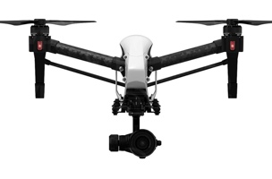
As much as I hate to say this… the biggest technical advance of the year might be the DJI Inspire 1. It was released last year, but it didn’t start gaining traction until 2015.
There have been many other technological advancements on all scanning fronts: aerial, terrestrial, mobile, hand-scanning and all the bits that fall in between and beyond. However, none really struck me like the DJI Inspire 1. I have put a significant amount of thought into what it represents.
1. It is Really Easy to Use
My first thought is that the Inspire 1 is somewhat of an iPhone of drones, where everything you need is packaged up in a tidy, clean-looking device that anyone can operate. It also appears to be a shift on the technological side from prosumer to professional quality, and a shift down in price from what many of the large survey and geospatial manufacturers were offering not that long ago.
2. It Will Saturate the Professional Market
Photogrammetry is nothing new, but a solution like the DJI Inspire 1, one that allows untrained consumers to capture the necessary imagery, has large implications. It means the market could soon be saturated by everything from the most technical engineers and surveyors to wedding photographers and even tech-savvy teenagers. All of this before UAVs are even fully legal in the US.
The only thing preventing such saturation might be the pending registration and training requirements from the FAA, but I doubt that will stop many people.
3. It Will Make UAVs TOO Popular
UAVs are cool, and their popularity is undeniable. Solutions like the DJI Inspire 1 will only make them more popular.
With such desire from the public, it seems inevitable that a lot of survey firms will start using UAVs just so they can say, “Yes we also offer that service.”
Clients already want us to use them even when they are not the best fit for the job. It pains me that I have been on site-walks this year where potential clients have expressed their desire for me to use a drone, a desire so intense that it overshadowed their real need for an accurate laser scan and survey in an environment that is not even conducive to aerial mapping.
The problem is bad enough that I am glad we don’t offer UAS mapping with a device such as the Inspire 1 yet, as it helps us avoid confusing conversations with our clients about which device we intend to use. That’s not even going into safety and privacy issues my company would face if we offered UAS mapping, or the problems our community may see from rapid simultaneous adoption.
4. It Will Help Us Innovate
All the negative aspects aside, it seems to be a great platform that is a step in the direction of simplifying an otherwise incredibly sophisticated aerial device. With all the normal UAS setup complexity out of sight, it leaves room for innovators to concentrate on adding other sensors to broaden what can be done with this type of platform—and that is what we really should be looking forward to.
I really want to like the UAS, but the swarm of confusion and ignorant popularity is dampening my motivation before we are out the gate. As one of the potential innovators, I am anxiously and optimistically waiting for the smoke to clear before diving in. Maybe 2016 will be the year of the UAS’s positive redemption with the FAA, providing a safe and reasonable path for good professionals to capture crucial data for projects of progress. Here’s hoping!
Jonathan Coco, Forte & Tablada — Advanced Measurements and Modeling for Forte & Tablada Engineering Consultants of Baton Rouge, LA. specializing in cutting-edge methods and outside-the-box solutions for a wide range of disciplines.


