In the spring of 1983, I was employed by my university professor to help him delineate the legal boundaries of an open-pit mining concession in the Amazon jungle. Little did I know, not only of the personal dangers, but also the professional challenges that I would face over the following 12 months.
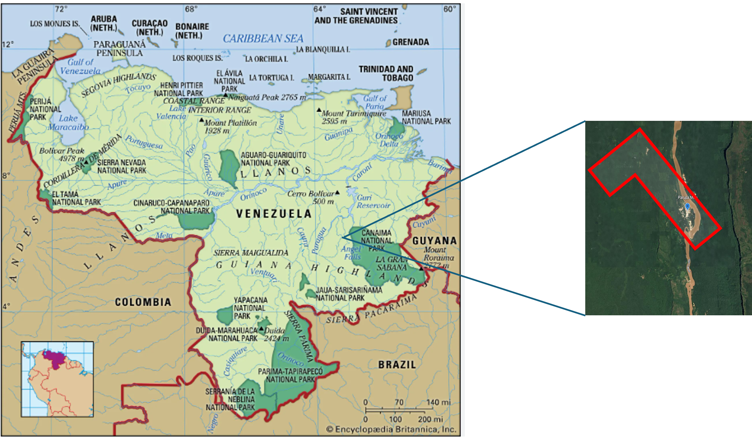
The particular plot of land to be measured was located at the very edge of the mining section of the Venezuelan Amazon region (N 5o 45’ 08” / W 62o 54’ 12”). It was only accessible by dugout canoe on the Caroni River, after a dangerous flight on a single engine plane from the city of Ciudad Bolivar. The shape of the concession was an inverted L, following the contours of the Parupa River and covering the most promising mining areas.
As the boundary laying progressed steadily, regardless of the 100% humidity and sweltering heat, I began to have some free time, and it was then that my employer asked me to look into the possibility of performing a depth profile of the river using an echosounder.
According to local geologists, gold and diamonds in the area accumulated in the deepest pockets of rivers with strong to medium currents. In the Amazon, Gold is not found in nuggets as in California or the Tumeremo Region, but in dust mixed with the sand of waterways such as the Parupa River.
I went back to civilization and in a few days found a portable Raytheon DE-719 and a water speedometer that would be easy to transport and install on a dugout canoe.
On my return to the jungle, I brought a new transit to replace the one that was permanently damaged by the humidity. I also brought the echosounder and enough basic supplies to keep the operation going while we found enough diamonds to sell and keep the mine viable.
We selected the larger and most stable dugout canoe we had available and installed the equipment, including the antenna at the front, the receiver/printer at the back and a basic speedometer on the right side of the vessel, which would allow us to calculate our position in relation to the river banks and the distance to the mine camp.

With this rudimentary and highly unstable setup, we embarked on a slow underwater survey of the river bottom. At all times we tried to stay right in the center between the two riverbanks in order to capture the center line of the water flow.
The speedometer was giving us an approximate distance from the point of departure, but the most important metric of our location were the notations that my boss made on the printer paper with the location of certain landmarks such as known fallen trees and beaches that were familiar to us. This way we would be able to locate the places that were better for our future prospecting.
At the end of two days of running the entire river within the concession in both directions, there was a clearly defined spot where the bottom dropped about 30 feet and we decided that this was the place to drop our diver, and this is where the story becomes a bit surreal.
The diver was one of our Yanomami workers, Toribio to be exact, with a rudimentary diving mask, wearing a lead belt and carrying a 3” sucking hose that he would use to suction the bottom of this ‘potential’ pit.

It was a delicate and extremely dangerous operation with one worker in charge of the air-generating system and another handling the sucking pump and the flow of sediment to the sorting machine. All of this equipment was placed on a support barge that was anchored to both sides of the river for stability.
Toribio jumped into the muddy waters and in a few minutes, we felt the pull of his cord letting us know to start the pump. A few seconds later a steady stream of water and sand began pouring into the vibration machine that helps us separate the stones from the diamonds. The operation lasted about fifteen minutes and when Toribio emerged from the river and we helped him climb onboard safely, we all felt relieved; the current at the bottom of the Parupa was strong and the slightest mistake could have ended in tragedy.

At the end the samples taken gave us a few small diamonds that when sold, paid for the operation, but no gold and very little proof that these deep pockets had more potential than the rest of the area.
At least the experiment paid for itself, and I could safely say that, apart from land surveying, I now had a bit of experience with underwater survey, which in the future would become a huge part of our profession. Today we have multi-beam echosounders and extremely complex bathymetric devices to accurately map the bottom of any water body, but in those days, it was improvisation with whatever was handy, to get the job done.