

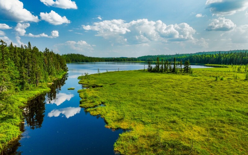
This week saw Earth Day come and go, with the annual global holiday to focus on our environment and the work we need to do to better protect our planet. This year, for what it’s worth, the theme was “Planet vs. Plastics,” but we know the problems facing our environment are varying and massive in scope. No one tool is going to solve all of our woes in one fell swoop, but scientists and other professionals for nearly every industry, discipline, and sector are looking at the ways their expertise can be applied to helping this mission.
As one might expect, the geospatial world is often at the center of this. Governments need to run simulations both to prepare for the growing number of extreme weather events occurring as a result of our effect on the environment, as well as to determine ways to slow these effects. All of these simulations, of course, rely on accurate spatial data collected and analyzed by geospatial professionals. The types of specific projects done in the geospatial community to benefit our planet, and/or adjust to our changing environment, varies greatly, using a number of different technologies for locations all around the globe. Below, you’ll find a selection of recent Geo Week News articles that highlight just a handful of the ways geospatial professionals are doing this work.
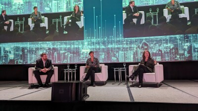
Geo Week's Keynote Showcases the Myriad Ways Geospatial Technology is Used for Good
We start not by looking at one specific use case, but rather at one of the keynotes given at this year’s Geo Week conference, held in Denver, Colorado in February. The talk featured presentations from Dr. Este Geraghty, Chief Medical Officer with Esri, as well as Ronda Schrenk, CEO of the U.S. Geospatial Intelligence Foundation. The presentations didn’t focus solely on the environment, but rather the ways geospatial technology can broadly be used for good. That includes things like assisting citizens living in conflict zones around the world, but also addressing important climate challenges, including the increasing number of wildfires around the world.
Surveying for Sustainability
Here we have another more broad look at how geospatial work can benefit our sustainability goals, this one specifically looking at the work surveyors do. As Carla Lauter points out, surveyors are at the forefront of mapping and monitoring ecosystems, providing a basis for so much of our important work. In this blog post, she runs through some examples of the work surveyors do on a daily basis to promote global goals for our environment. This includes, crucially, their work on projects to develop areas for renewable energy sources, such as solar farms or wind turbines, among others, and monitoring at-risk coastal areas.
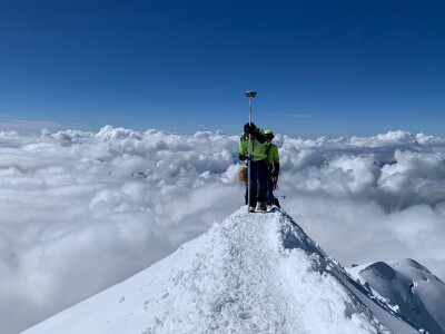
Inside the biennial survey of Mont Blanc
After a couple of more general looks at the ways geospatial work can be used to help monitor our planet, we delve into a few specific case studies, starting with a biannual trek to the top of Mont Blanc, the highest mountain in the Alps. Every two years, a group of climbers and surveyors (some of them checking both boxes) climbs to the peak of Mont Blanc to measure the altitude of the peak and model the mountain’s ice cap. This work has been done since 2001, giving us data going back over two decades at this point, which provides a chance to do real comparable work over a relatively long period of time. Geo Week News spoke with Farouk Kadded, who has participated in every climb, about this work and the findings from the most recent ascent.
Read the full article below >>
Harnessing advanced satellite data for a hydrological digital twin
For this next case study, we stay in Europe but move from the peaks in the Alps to the shores along the Mediterranean, and change from on-the-ground GNSS technology to data collected from space. This article focuses on the work being completed by a team of scientists in Italy, led by Dr. Luca Brocca, to monitor how climate change is affecting the water cycle. Dr. Brocca spoke with Geo Week News about the project, sharing how satellite data has been used to create a digital twin of the water cycle, which in turn allows professionals and government officials to run simulations based on a variety of scenarios to ensure coastal areas are prepared to deal with current conditions.
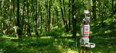
Scientists use laser scanning to show UK woodlands are a larger carbon sink than previously believed
Now, we head north from the Mediterranean up to the United Kingdom, with scientists using terrestrial tools to monitor forests. For this article, Geo Week News spoke with Dr. Kim Calders, who is leading a team that used laser scanning technology that is typically used for built-world infrastructure to scan and analyze trees. This particular project was completed in forests near Oxford University, but the study found that this technique of using terrestrial laser scanners to create models of individual trees led to more accurate measurements of how much carbon is being contained in a tree’s biomass. Specifically, in these particular trees the study found that traditional measuring techniques may have underestimated carbon biomass by as much as 77 percent.
How Kaua'i County uses GIS to future-proof development
Finally, we head out to the Pacific for our final case study, looking specifically at how communities are reacting to the effects of climate change at the local level. In this story, Geo Week News spoke to Alan Clinton, an administrative planning officer with Kaua’i County in Hawaii. As a coastal community, the county has been dealing with sea level rise, a major issue for developers who are looking to construct new buildings – and renovate older ones – along the coast. To preemptively counteract some of these potential problems, the county codified a Sea Level Rise Constraint District, which uses GIS and sea level data from NOAA to mandate any new construction, or renovation which repair over 50 percent of the value of the structure, be on lifts at least two feet above projected sea levels for the year 2100.


