


The construction industry has long been plagued disproportionately by “conflict” that few industries have experienced to the same degree – “[rising] project cost, project delays, reduce[d] productivity, loss of profit or damage in business relationships” (ref Jaffar et al). This is compounded by the “fragmented and unintegrated” nature of the construction industry (ref Liu et al).
However, the tides are changing, as scholars have noted: “project integration is believed to significantly improve project performance, […] such [as enhancing] coordinating processes, improving the integration of information and knowledge, promoting innovation, and managing risks comprehensively” (ref Liu et al). I’ve previously discussed the importance of technologists prioritizing interoperability, and data connectors to eliminate inefficiencies and promote process improvement; true, studies have shown the value of system integration and collaboration on facilities management in the AEC industry (Shen, et al) and on the construction supply chain (ref Cheng et al). Similarly, studies find integration to show additional benefits, such as “net benefits that stem from increased productivity and reduced cost, reduced project times owing to early supplier involvement and team integration, [and] improved quality through the focus on learning and continuous improvement” (ref Gadde and Dubois).
Other advanced technology integrations, such as BIM, which I’ve discussed before and has been studied by scholars (ref Gao, et al), Lidar, and IoT have their place in transforming the industry for the better.
As we wrap up the first full month of 2024, I’ll use this article to explain how some of the above-mentioned technologies may be used to completely transform the construction process, from start to finish, and increase productivity outcomes.
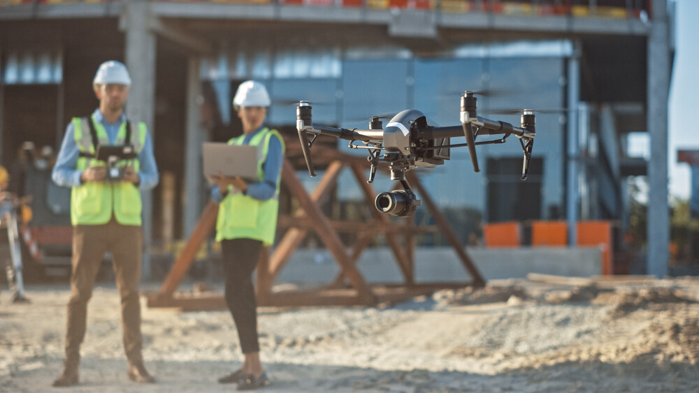
Surveying
Construction drones have shown promise in helping improve surveying of sites before construction teams have broken ground. Scholars studying the use of multirodar drone technologies in construction project management note these drones can replace bulkier land surveying tools (such as tripods, total stations, and GSP equipment).
“Multirotor drones equipped with cameras, autopilots, and image-processing software,” they note, “can be applied to land surveying and mapping in construction projects for providing faster and less costly land surveys” and can provide a greater degree of surveying capabilities via: “a camera mounted on the drone [...] pointed down towards the ground to measure 3D dimensional coordinates” (ref Li and Liu). “3D models can be then created by aerial photogrammetry,” the authors go on, adding that “Compared with a traditional GPS survey that consists of 1800 individual points in the area of 60,000 m2, the drone-based photo- grammetric survey approach is capable of autonomously collecting 5,500,000 colour-coded points and producing a result in the format of an orthophoto.” Drone-based surveys also reduced time to one-third and increased the point density by more than 3000 times, the authors added.
When paired with other digital tools, like lidar and BIM, surveying accuracy and collaboration can be greatly improved. Scholars, in fact, recommend such an integration to achieve real-time construction quality control (ref Wang, et al). The application of lidar has also been seen used in conjunction with surveying of long-term ground settlement and land reclamation (ref Lee, Jo, Oh).
Site-prep
There are numerous mobile indoor mapping technologies that can help prep jobsites, among them lidar (e.g., handheld lidar, backpack lidar, lidar trolleys) especially handheld and backpack lidar devices that “present a better adaptation to the physical requirements of indoor environments, where corners and stairs are present” (ref Otera, et al). For site prepping installers, 360° 3-Plane lasers allow for fast and easy alignment, leveling, squaring, and transfers, facilitating an easier layout of large spaces with a single tool.
An additional technology that has continued to show promise in site preparation is BIM, particularly in the area of clash detection, which is what an SME told me recently on the subject. BIM has shown to help lead to "rarer mistakes,” as an “effective tool for managing medium- and large-scale projects since it can help to boost profitability, cut expenses, and enhance time management” (ref Datta, et al). Studies have shown the use of BIM to be successful against rebar clashes (ref Chidambaram) and other hard-to-predict, cost-generating mistakes.
Site Monitoring and Finishing
Aside from surveying and site prep, there exist many technologies to improve productivity outcomes onsite:
- Drones – Just as drones can be used to prepare a site, so too can they to perform site flyovers, which numerous studies have shown to be useful in respectively providing remote quality and safety (ref Perera, et al; ref Tariq) and assurance monitoring (Choi, et al; Mayowa Nwaogu, et al).
- IoT and wireless technology – The Internet of Things has proven to deliver many technologies to make jobsites more productive and precise in their access to real-time data. At the installation-level, there’s smart tools that can deliver precision fastening, protect against kickback events, and provide utilization data to provide proof-of-work/QA/QC documentation. At the site monitoring-level, several wireless technologies exist that can help project managers and stakeholders maintain visibility to projects and associated inventory, an SME recently told me:
- Bluetooth Low Energy (BLE) - newer BLE technology is capable of creating “mesh networking,” and useful to address the demands for high accuracy indoor location services.
- Cellular – low-power smart cellular sensors have provided a breakthrough similar to low-power Bluetooth in that they are capable of creating incredibly low power useful for asset tracking while delivering the constant connection of a cellular network.
- Ultra-wideband - an exciting positioning location technology that provides pinpoint accuracy, the same proximity-based technology used to provide security in automotive settings, essentially what determines if your keys are inside your car or outside your car.
- Bluetooth HADM (High Accuracy Distance Measurement) - a Bluetooth technology that helps tell precisely where something is (like a specific product on a grocery shelf or, when applied to construction inventory, where on a tool crib shelf a saw is, or where on site it was precisely left), rather than an approximation.
- Bluetooth Low Energy (BLE) - newer BLE technology is capable of creating “mesh networking,” and useful to address the demands for high accuracy indoor location services.
With 2024 now here, and project managers combatting with the industry’s expensive productivity problem, it’s worth it to offer a reminder of how far the industry has come. As we look to apply evolving technologies to solve current-day problems and, importantly, improve collaboration, communication, and transparency through technology, I’m confident the industry can tackle even the most staggering of scary, headline-grabbing productivity metrics.
References
- Cheng, J. and Law, KH., Bjornsson, H., Jones, A., and Sriram, R. (2010). A service oriented framework for construction supply chain integration. Automation in Construction 19(2), 245-260, https://doi.org/10.1016/j.autcon.2009.10.003
- Chidambaram, S. (2019, 06). The application of clash-detection processes in building information modelling for rebars. Smart Infrastructure and Construction 172(2), 53-69, https://doi.org/10.1680/jsmic.20.00005
- Choi, H-W., Kim, H-J., Kim, S-K., and Na, W-S. (2023, 08). An overview of drone applications in the construction industry. Drones 7(8), https://doi.org/10.3390/drones7080515
- Datta, S.D., Sobuz, M.H.R., Mim, N.J. and Nath, A.D. (2023). Effectiveness of using building information modeling (BIM) tools in the project management: a case study. Revista de la Construcción. Journal of Construction, 22(2), 306-320, https://doi.org/10.7764/RDLC.22.2.306
- Gadde, L-E. and Dubois, A. (2010). Journal of Purchasing & Supply Chain Management 16, 254-264, http://doi.org/10.1016/j.pursup.2010.09.002
- Gao, X., Wu, Y., and Li, Y. (2019). Research on information integration of construction project management based on BIM [Conference presentation]. IOP Conf. Series: Earth and Environmental Science 267, http://doi.org/10.1088/1755-1315/267/3/032069
- Jaffar, N., Abdul Tharim, A-H., and Shuib, N-N. (2011). Factors of conflict in construction industry: A literature review [Conference presentation]. The 2nd International Building Control Conference 2011. http://doi.org/10.1016/j.proeng.2011.11.156
- Lee, J., Jo, H., and Oh, J. (2023, 07). Application of drone LiDAR survey for evaluation of a long-term consolidation settlement of large land reclamation. Applied Science 13(14), 9277, https://doi.org/10.3390/app13148277
- Li, Y. and Liu, C. (2018,04). Applications of multirotor drone technologies in construction management. International Journal of Construction Management 19, 401-412, http://doi.org/10.1080/15623599.2018.1452101
- Liu, Z., Ding, R., Gong, Z., and Ejohwomu, O. (2013, 03). Fostering digitalization of construction projects through integration: A conceptual project governance model. Buildings 13(2), 825, https://doi.org/10.3390/buildings13030825
- Mayowa Nwaogu, J., Yang, Y., Chan, A., Chi, H-l. (2023, 06). Application of drones in the arcitecture, engineering, and construction (AEC) industry. Automation in Construction 150, 104827, https://doi.org/10.1016/j.autcon.2023.104827
- Otero, R., Lagüela, S., Garrido, I, and Arias, P. (2020, 12). Mobile indoor mapping technologies: A review. Automation in Construction 120, 103399, https://doi.org/10.1016/j.autcon.2020.103399
- Perera, et al. (2022). Unmanned aerial vehicles (UAV) for safety in the construction industry: a systematic literature review [Conference presentation]. IOP Conference Series: Earth and Environmental Science 1101, http://doi.org/10.1088/1755-1315/1101/9/092008
- Shen, W., et al. (2009, 09). Systems integration and collaboration in architecture, engineering, construction and facilities management: a review. Advanced Engineering Informatics 24(2), 196-207, https://doi.org/10.1016/j.aei.2009.09.001
- Tariq, U. (2021, 11). Applications of drones for safety inspection in the Gulf Cooperation Council construction. Engineering, Construction and Architectural Management 28(9), https://doi.org/10.1108/ECAM-05-2020-0369
- Wang, J., Sun, W., Shou, W., Wang, X., Wu, C., Chong, H-Y., and Liu, Y. (2014, 09). Integrating BIM and LiDAR for real-time construction quality control. Journal of Intelligent & Robotic Systems 79, 417-432, http://doi.org/10.1007/s10846-014-0116-8


