Contributed by Brian Mayfield and Greg Itzstein, Pointerra
When a major hurricane hits, a large Investor-Owned Utility (IOU) can burn through tens of millions of dollars per day just to stabilize, assess, and begin restoring the grid. In some cases, the effective daily run rate is far higher. A large southeastern IOU’s restoration effort after Hurricane Irma, for example, was ultimately recognized at roughly $1.3–$1.375 billion in storm costs according to publicly available records. They restored power to essentially all 4.4 million affected customers in about ten days, which implies a core restoration window with an effective spend well above $100 million per day, even allowing for costs incurred before and after that period. Another southern IOU has received approval to recover around $1.5 billion for Hurricane Ida, while one of the largest IOUs in the region has estimated $2.4–$2.9 billion in restoration costs across three major hurricanes in a single year.
Those numbers put day-to-day storm costs into stark perspective. Even if you take a conservative view and spread $1–2 billion of restoration spend over a four- to six-week period, you land in a range of $25–$70 million per day. For mid-sized events, many large IOUs quietly benchmark internal storm “burn rates” in the $8–$12 million per day range. For the largest hurricanes, the true figure is often much higher once contractor labor, mutual-aid crews, materials, logistics, and internal overtime are fully accounted for. In that environment, every hour of uncertainty has a tangible price tag. The question is no longer whether utilities and agencies can afford to invest in better storm intelligence; it’s how much longer they can afford not to.
What consistently drives these costs is not just the physical damage, but the time it takes to understand that damage with enough confidence to act. Traditional storm response relies on manual patrols, fragmented datasets, and delayed reporting. Trucks roll based on incomplete information. Work gets reassigned as new damage is discovered. Regulators, emergency managers, and community leaders are left waiting for a coherent picture of what happened. The result is a restoration process that is heroically executed, but structurally inefficient.
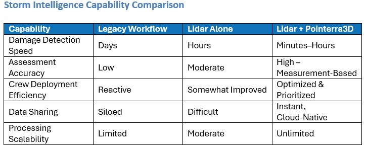
Lidar-enabled storm response, powered by platforms like Pointerra3D, is changing that equation. High-fidelity geospatial data provides an objective, measurement-based view of the network in its most vulnerable state, and Pointerra3D transforms that data into operational intelligence fast enough to matter. Instead of spending the first 48–72 hours discovering where the problems are, utilities and agencies can spend that time fixing the highest-impact problems first. When the daily cost of delay is measured in eight, ten, or even a hundred million dollars, that shift from hunting for damage to executing against a clear, data-driven plan is where real value is created.
Why Data Matters in Storm Response
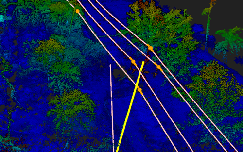
Storm damage is three‑dimensional by nature. Poles lean, wires sag, vegetation shifts, structures deform, and debris alters access routes. Traditional 2D imagery, even when available quickly, cannot capture vertical relationships or subtle geometric changes that define electrical and public‑safety risk.
Lidar fundamentally changes the equation by directly measuring geometry rather than interpreting it. The result is a dense, accurate point cloud that reveals the exact condition of every pole, span, tree, and terrain feature in the affected region. Because lidar is unaffected by lighting, shadows, or camera angles, it produces a consistent source of truth regardless of conditions. This is critical for storm response, where uncertainty carries a real operational cost.
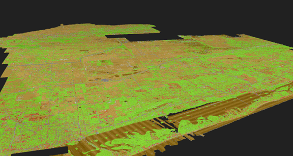
Equally important is the sheer scalability of aerial lidar collection. Aircraft can capture hundreds or thousands of network miles in a matter of hours, generating a comprehensive post‑event snapshot. When paired with the right platform, lidar becomes the fastest, safest, and most reliable method for assessing broad‑scale storm impacts.
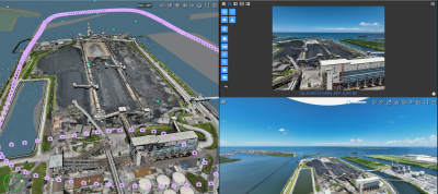
Pointerra3D removes the complexity that has historically constrained lidar use during storm response. Instead of requiring days of processing on specialized desktop machines, Pointerra3D ingests lidar directly into a cloud‑native environment engineered for speed and scale. Strip alignment, automated classification, and AI/ML-driven feature extraction convert massive datasets into usable intelligence within hours.
Because Pointerra3D operates entirely in the cloud, every stakeholder from GIS teams to storm commanders to field supervisors accesses the same digital twin through a browser or as an integration into another enterprise application such as GIS or a work order management system. This eliminates the version‑control challenges and data‑handling bottlenecks that previously slowed storm workflows. As soon as lidar is uploaded, it becomes actionable.
The platform also bridges data and operations. Downed poles, conductor breaks, vegetation strikes, and infrastructure anomalies are automatically detected and surfaced within intuitive reporting dashboards. These insights feed directly into crew packets, logistics decisions, system operations, and command briefings. Storm response shifts from a discovery exercise to a coordinated execution cycle.
A Demonstration of Scalable Storm Intelligence
One of Pointerra’s customers, a large IOU in the Southeastern US, operates in one of the most hurricane-exposed regions with yearly storms that routinely disrupt large portions of its service territory. After a major event, this utility’s first operational priority is simple but critical: identify which parts of the network are damaged, how severe the damage is, and where crews need to be deployed first. Historically, this meant dispatching teams into the field to patrol feeders on foot or by vehicle, searching for downed poles, broken equipment, and inaccessible spans. While effective, this approach is slow, labor-intensive, and inherently risky – especially in the chaotic hours immediately after a storm.
The utility sought a way to accelerate this early triage phase and reduce reliance on manual discovery. The utility partnered with Pointerra to use post-storm collected lidar as a rapid, objective source of truth. The concept was straightforward: if lidar could capture the actual physical condition of the distribution network in 3D, Pointerra3D could process that data and detect damaged or missing structures faster than traditional methods.
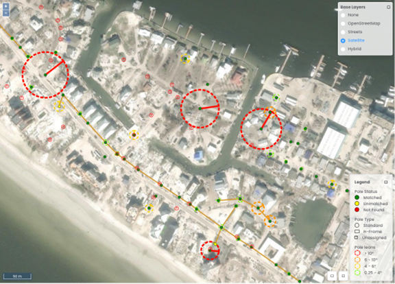
Pointerra leveraged its existing Poles & Wires feature-extraction workflow to create a programmatic method for scanning the network and identifying any pole that appeared downed, leaning, missing, or structurally anomalous. By integrating this with the utility’s GIS records, the platform produced targeted reports that included the feeder, the precise structure location, and the nature of the anomaly. What previously required field crews to drive or walk miles of line could now be surfaced in hours at network scale once the lidar was collected and uploaded.
The proof-of-concept, conducted using data collected after Hurricanes Nicole and Ian, demonstrated exactly how lidar and cloud-native analytics change the speed and quality of storm intelligence. Instead of waiting for scattered field reports to paint a partial picture of the damage, the utility could quickly generate a geospatially accurate, system-wide view of which structures were impacted. Storm leads could triage and prioritize feeders more effectively, dispatch the right crews to the right locations, and communicate early situational awareness to leadership and emergency-management partners.
Operationalizing Lidar at Enterprise Scale
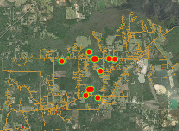
Another one of Pointerra’s large IOU customers operating in the southern US, developed a program around the use of AI-based tools for storm response, which helped illustrate how lidar‑based workflows evolve from proof‑of‑concept to enterprise capability. Operating across four states, this utility faces storms that impact millions of customers and thousands of miles of infrastructure. Traditional manual assessments could not keep pace with the scale of required triage.
During a recent pilot study, the utility contracted with Pointerra to automate the ingestion and analysis of newly collected lidar and imagery. Despite real‑world constraints, such as aircraft downtime, weather delays, mixed sensor performance, the workflow delivered fast, accurate damage identification. Impacts that once took days to detect became visible in hours, allowing more efficient mobilization of field crews and support contractors.
A Modern Storm Workflow: Integrated, Collaborative, Repeatable
A lidar‑enabled workflow powered by Pointerra3D unifies previously disconnected pieces of the storm lifecycle. Lidar and imagery are collected shortly after impact. Pointerra3D processes the data immediately, enabling analysts to compare post‑storm conditions against baseline digital twins. Automated change detection highlights broken poles, leaning structures, conductor displacement, vegetation strikes, and debris obstructions.
As all data lives in a centralized cloud environment, every user sees updates in real time. Operations teams can translate insights into crew work packages that include maps, measurements, and risk indicators. Field teams can validate repairs with before‑and‑after comparisons. Regulatory, safety, and communications teams gain authoritative visual records to support compliance and public reporting.
Interagency coordination also becomes significantly easier. DOT, FEMA, state emergency offices, and municipal authorities can work from the same 3D operational picture, reducing conflicting assessments and improving joint decision‑making during large restoration events.
Conclusion: Precision, Speed, and Confidence
Storm response has always required courage, coordination, and commitment. What it now requires, given the severity and frequency of modern weather events, is precision. Lidar delivers the physical truth, and Pointerra3D converts that truth into operational intelligence. Together, they enable utilities and agencies to act earlier, act smarter, and act with greater confidence.
As utilities and government partners seek new approaches to resilience, the combination of lidar and Pointerra3D will form the backbone of next‑generation storm programs. Those who invest now will be the organizations that restore faster, communicate more transparently, and build systems capable of withstanding the storms still to come.
Pointerra works closely with technical teams within leading utilities providers globally to develop tools solving everyday challenges around grid resilience and storm response through high fidelity digital twins and industry specific analytics. Learn more about digital twins for utilities here: https://www.pointerra.com/industries/utilities/ or get in touch with the team at [email protected].