Sponsored by BAAM.Tech
Technological innovation has completely changed the way surveying can be done, with constant improvements in the world of data collection. On top of that, unlike other similarly established professions, surveying has traditionally been more willing to take advantage of these innovations, and there are many large firms living on the cutting edge. That being said, entering this space can be challenging and intimidating for smaller and mid-sized firms, who may see this technology at trade shows and online, but struggle knowing where to even begin to put it into practice.
Between getting a full understanding of the technology available, creating the budget to acquire it, and having the resources available to fully utilize these tools, too many barriers exist for many firms to even begin, to say nothing of actually scaling up. That doesn’t mean it’s impossible, though. BAAM.Tech has positioned themselves to be stewards of this pathway, helping these firms not only get in the door and find the right starting place, but to drive growth and scaling.
The company employs a "crawl, walk, run" approach with new customers, traveling out to them and offering to help with as much or as little as needed, with everything including demos, actually collecting data, extracting data, and providing training on the ground for every aspect of a project. Fully grasping these processes is, well, a process, and BAAM.Tech helps customers take that journey at the speed necessary to maximize results.
They continue to strengthen their position in the industry with recent partnership deals with Terrasolid and RIEGL, and can provide both the technical and business know-how to build ROI. Not only offering hardware and software for different levels of scale, but also training for any new addition to a firm’s toolkit, BAAM.Tech can help a customer find their place on the geospatial technology journey and provide access to the pathway for advancement.
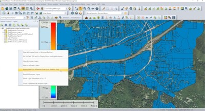
It’s worth considering, though, what exactly that path looks like, both in terms of the technology needed as well as, perhaps as or more importantly, the investment required. Generally to get started, a firm will likely need to have one mid-level employee dedicated to collecting and analyzing data, most likely through aerial photogrammetry for aerial modeling and ortho photography projects. For this, we’re talking about an investment of somewhere in the $10,000-$30,000 range, using a drone like the DJI Mavic 3 Enterprise and software like Agisoft or RedCatch, both of which can be acquired through BAAM.Tech. That comes along with training on the basics around ground control, RTK and PPK data capture, datum transformations, and statistically checking a project, or any combination required.
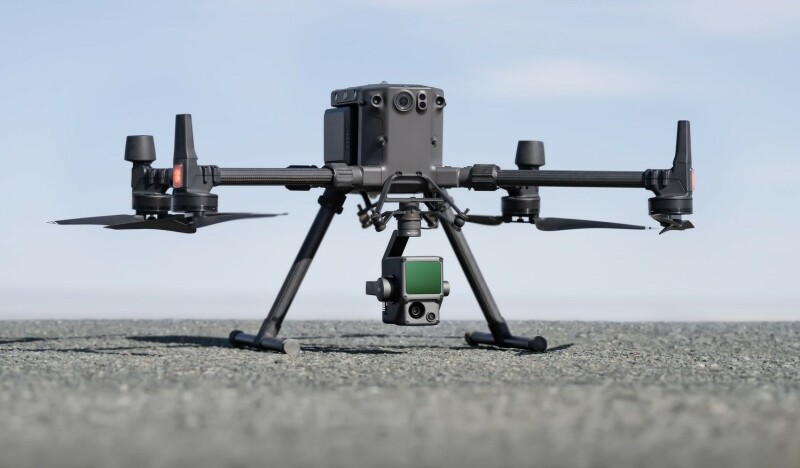
From there, once a firm is ready to move into some larger projects for things like topographic mapping, agriculture and forestry management, or energy and infrastructure inspection, that’s the point to start implementing aerial lidar approaches, moving up to a DJI M300 with a Zenmuse L1 sensor supported by Terrasolid’s point cloud software. Here, we’re talking about a bit of a bigger investment – though still likely under six figures – and more advanced knowledge necessary around how to plan lidar-enabled missions and how to process and analyze the resulting data.
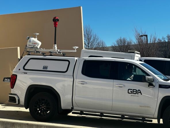
So far, these solutions have all come from above with UAVs, but mobile mapping can open up a whole new breadth of projects and abilities and is the next step on our pathway. At this point, firms are investing upwards of $350,000 for the hardware, such as the RIEGL VMY Series – the VMY-1 can be used with a UAV as well as a terrestrial mobile mapping system – but assuming the process was followed correctly that investment will be worth it. Implementation of mobile mapping opens up some lucrative and growing fields, like GIS mapping, asset management, city modeling, and mapping for autonomous vehicles, all of which are growing fields for which demand is only expected to grow in coming years. Firms will likely need to start employing multiple personnel at this stage who can focus solely on data collection or analysis.
This stage can also be upscaled to a final level of the pathway with advanced lidar methods, covering many of the same deliverables, but more accurately and efficiently with RIEGL’s VMX and VMQ Series, along with their software stack, and requiring an investment of upwards of $1 million. Getting through this whole pathway doesn’t happen overnight, and requires care, but is possible with positive ROI throughout the journey.
Don’t just take our word for it, though. Speaking with Michael Lay from George Butler Associates, he told Geo Week News about his experience in scaling up working alongside BAAM.Tech. Lay describes the main barrier to even getting started on this path as many surveyors fearing that this will replace their jobs, but in reality it is only changing and enhancing them. There may be a reduction in some of the tedious fieldwork, but that’s replaced by learning this new technology, including the processing software. In fact, Lay relays a story about one of his team members who has been in the industry for 35 years becoming one of their most eager and successful lidar data processers.
Once that barrier is crossed, though, Lay describes a much more efficient operation with new projects being realistic targets that wouldn’t have been on their radar before. He talks about working closely with BAAM.Tech upon the implementation of their mobile mapping division, leaning on them for training. He said, “I was only able to [start our mobile division] because of the expertise of BAAM.Tech. They had those SME’s, those people we could lean on when we’re having the difficult items that we don’t necessarily have the ability to work through.” He notes BAAM.Tech’s presence allowed them to hire for leadership qualities who may not have a ton of experience in that specific area.
The results have spoken for themselves. Lay tells Geo Week News that a couple of new employees were added to his roughly 20-person team over the last couple of years, and with that 10 percent increase in manpower, supported by this journey along the technological roadmap, they’ve achieved upwards of 70 percent increase in revenue over the last two years. And this is only the middle of that journey, with more technology to be added and even more detailed and lucrative projects becoming available to be completed more quickly.
But it is a process, and that’s an important piece to keep in mind. Lay recounts how this has been a roughly five-year process just to get to this point with his team, and it’s been done incrementally. They started by outsourcing some of these jobs just to get a feel for how it works, and it’s not something you can bring to the table with new clients until you really know you have a firm grasp on it.
At the end of the day, though, it’s a journey that is possible for far more surveying teams than are taking advantage. That first step can be intimidating, and it can feel impossible to scale up to the point of using the best available tech. But with the right knowledge, equipment, and training from BAAM.Tech, that journey is achievable with scalable ROI.
If you want to move forward on your lidar journey, email us at [email protected]