

Sponsored by Autodesk
Projects undertaken by Civil Engineers - from bridges and tunnels to municipal infrastructure like wastewater treatment plants - are often massive and complex. Adding to this challenge, often the infrastructure they need to repair, rebuild or inspect predates any kind of digital documentation, making it challenging to get a whole view of the project. The ability to collect data through reality capture, generating point clouds and ultimately 3D models and representations of as-builts, represents a breakthrough in connecting the past to the future when it comes to infrastructure projects.

Ramesh Sridharan, Director of Reality Solutions and Existing Conditions for AECO at Autodesk, has been working with and dreaming in point clouds and reality capture for the majority of his career, starting from when he graduated from higher education. In his 20+ years of experience in the industry, he’s honed in on the practical realities and applications of reality capture, especially when it comes to civil infrastructure projects, says Sridharan.
“In the last two decades of working, I can truly say I’m at the intersection of reality capture, AI, ML, automation – and long before those were buzz words,” he laughed.
It is that background that Sridharan brought with him into Autodesk when he joined through an acquisition. Today, he leads the reality solutions team at Autodesk, where he gets to work across the entire product portfolio to help teams capture and make smarter use of real-world data. We connected with Ramesh to talk about the intersection of technology and infrastructure, and the value that reality capture can bring to infrastructure projects.
Why do you think reality capture is becoming such a critical tool for infrastructure?
Well, it’s simple. We are asking our infrastructure today to do 21st century things with 20th century tools. A lot of systems we rely on every day - the bridges, the water lines, the roads, majority of today’s infrastructure – we built before the internet was a thing. And now, we're expecting that infrastructure to support growing populations and vehicles, electric vehicles, extreme weather events and more.
I jokingly say that these big infrastructure projects don't come with a control-Z [undo] option. It’s costly, financially and environmentally, and that's exactly where reality capture comes into play. Reality capture gives us the confidence to start projects with eyes wide open.
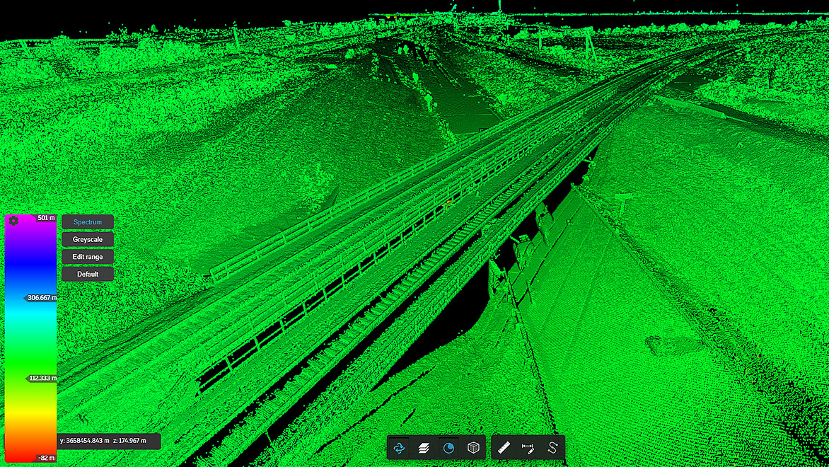
Reality capture tools like Autodesk’s ReCap Pro, which is within the AEC Collection, let’s teams see and understand what's actually out there before anyone picks up a jackhammer to work on it. It's like a flashlight for infrastructure planning. That’s what I like about it - instead of relying on outdated plans or vague site photos, it gives you a precise digital snapshot of what's out there in the planning process. So, no more surprises when you dig, and no more costly rework.
The latest American Society of Civil Engineers Infrastructure Report Card gave the US a C grade overall for our infrastructure. This means that we have room to level up, and reality capture will help with current and future projects.
What does reality capture enable in terms of collaboration?
I talk to customers every day, and tell them, [reality capture] replaces uncertainty with sharing an understanding of what exactly is out there. Everyone can look at the same scan and “get it” to make more informed decisions going forward.
When we used to talk about collaboration, that usually meant I can share my files from the cloud or I could email you a static file faster or, honestly, even people today still shipping hard drives, when they have large amounts of data. But that’s an antiquated definition of collaboration because it often comes with: What version is this? Why is this missing? Are we talking about the same intersection?
Now with reality capture and ReCap Pro, we can have a cloud-based visualization where everyone can open a scan in the browser, zoom around in 3D, drop comments, and be on the same page… without ever downloading a file. Now that’s a true and real-time collaboration. Decisions happen faster, there is less back and forth, fewer mistakes. Let's be honest, if you can cut down on five rounds of “can you resend the file?” that’s a win.
What are the other challenges that reality capture and ReCap Pro help when it comes to civil engineering specifically?
Reality capture gives users the ability to understand the existing conditions without shutting down the asset; they can get the precise information they need for the model. Whatever they collect becomes a baseline for planning repairs and upgrades, and long-term asset monitoring. And once you collect the data, you don't have to keep on sending folks back into the field. This process saves money and improves safety for teams in the field. It is changing how infrastructure is planned, designed, and made today.
In April, several big updates were announced for ReCap Pro 2026 - what should infrastructure professionals know about those?
ReCap Pro has been in the industry for quite some time, but in the last couple of years, especially in this release, we are laser-focused on how to make point clouds in ReCap Pro faster, smarter, and more collaborative.
The first update is that ReCap Pro now fully supports a cloud-based workflow using Autodesk Construction Cloud. That means you can publish your large-scale scans - and I mean large, we’re talking terabytes - to the cloud and work with your team in real time. No more downloading of massive files, no more caching in the local folder, and wondering what the latest version is, none of that. It's all up there.
And the cloud is not just for data sharing. It has a full set of visualization, sharing, model coordination, 3D geometry extraction, even clash detection capabilities. Many of our customers call it a “game changer in the lidar industry” because you can work with massive point clouds in your browser, with no heavy software, no data transfers, just a link and URL.
Another update is that today, when we think of point clouds and reality capture, the first thing that comes to our mind is lots and lots of points… but that’s not why users are collecting the data; they want the information behind it, the objects it collects. In the 2026 version, we are taking that leap, and we are treating it as the next step in the lidar industry: object-based segmentation. Now, with the latest segmentation and mesh workflows that we launched this month, customers can convert a point cloud into meaningful objects, connected as a mesh format that’s easy to understand. They can isolate objects, like light poles, fire hydrants, and traffic lights. This allows you to work on it as an object, not just point cloud data.
If you ask a civil engineer what they want, they want feature lines, COGO points, or assets. In ReCap Pro, we have a cloud-based feature extraction, and you can extract anything you want, from feature lines to assets for road curbs or gutters, drainage water flow, road center lines, rail lines, you name it, they can get extracted. That’s from Autodesk Construction Cloud without downloading anything. Some have automated template-based extractions, so you don’t even have to manually extract it. Now, you can take that information to your civil engineering workflows, like Civil 3D for example, and complete your detailed design.
The latest release of ReCap Pro also comes with the Revit tools that can leverage this mesh. Now you can augment your existing Revit model, or you can create something from scratch, which means that with the interaction between Revit and AutoCAD, you can bring those meshes and have a floor plan, modeling, and measurements. In civil infrastructure, this enables 3D bridge modeling, asset management for roads, rails and highways. For buildings, some users are bringing their meshes into to Inventor for MEP system workflows or even Autodesk 3ds Max or Maya for visualization and rendering.
Do you see these new workflows changing how point clouds are used?
“I strongly believe point clouds is means to an end, not an end. The usage of point clouds and the data it generates can change how we plan, design, and operate buildings and infrastructure.”
At Autodesk, we truly believe in reality capture and it’s why we continue to partner and invest in this space – from viewing the point clouds, meshes in the browser, taking measurements, and sharing them. Visualization is the starting point for the infrastructure project, but that's not the end. The true power of reality capture lies in extracting intelligence from the raw data, insights that can drive design, modeling, planning and decision making. Only [using point clouds for] visualizing a scan is only tapping 10 to 20% of its potential.
ReCap Pro is designed for use beyond the visualization aspect with automatic classification, intelligent decimation, and quickly generating surface contours, for example.
The goal is for teams to spend less time wrangling data, more time solving the problem. It should enable designers and modelers to get a job done accurately and efficiently. These updates are saving teams a lot of time and headaches. One team told us that they used to take three days to align scans, extract features and clean up noise just for the intersection. When they changed their workflows, they discovered it took the same projects at most a few hours to complete.
And another example is extracting a BIM model from the scanned data. Usually, you collect redundant data, and it takes literal hours just to import the data into a product and start working with it, and start to incorporate it into the BIM. Now, within a matter of minutes, you can convert that scan into intelligent segmented meshes and start using it for many use cases and easily convert that to BIM model.
There are teams right now who collect data, push the data into the cloud in the field, and the design team can start looking at it before they even drive back to the office, because it's already being processed in the cloud.
How does the partnership with Esri bring teams together?
As I mentioned, we also support feature extractions from reality capture so that features can go into Civil 3D for detailed designing, but we don’t stop there. We can take that into a GIS asset database. So now, GIS folks can leverage these results as well, and all of this is happening within the cloud via Autodesk Construction Cloud, so data can flow across stakeholders, allowing them to make better, more informed decisions and work in smarter, more connected workflows. That’s what the client wants, and they can get the project done the way they want.
What do you see as on the horizon for these products and workflows?
From a technology perspective, we partner with our customers on what capabilities and features they need to get their jobs done. Our customers are continuing to push the technology to the next level. They're using it for new projects because they have new requirements or new constraints on every project. They are looking for different ways of working, which means the product cannot be reactive; we have to be proactive.
Moving forward, we want to continue to push on more practical aspects of automation. We know our users want to understand how automations are supporting them, and how much time and resources it saves. We understand that this is what matters most to our customers.
Additionally, we will continue to focus on the real-time information cloud-native workflow and how it helps our customers to collect scans, upload, and start extracting the value as quickly as possible. With segmented mesh workflows, we are planning to continue enhancing those capabilities. You’ll be able to expect smarter feature recognition, more mobile integrations, tighter links to digital twins, AR, VR, XR workflows, and more tools that can make this reality capture data accessible to everyone, not just specialists.
Now a lot of people are working in the designing and modeling environment, but not everyone today uses reality capture data. Our dream is, scan today, model tomorrow, and build with the confidence. I think we are getting closer on every release from ReCap Pro.
Reality capture - “from niche to a must-have tool”
A little over a decade ago, you would be hard-pressed to find any non-experts talking about the uses of reality capture. But as reality capture has gotten more accessible and as use cases and success stories have mounted, Sridharan is excited about its evolution.
“What excites me most is that reality capture has gone from niche to a must-have tool. It's no longer just for the surveyors or technical early adopters, it is now becoming an essential part of how infrastructure gets planned, designed, and delivered, and that's a big shift. It's enabling faster decisions and better models, and so on. I'm just incredibly fortunate to work on something that I'm really passionate about.”


