

SPONSORED BY CINTOO
With the prices of laser scanners dropping quickly, more and more point clouds are captured each day—for documenting site conditions, scan-to-BIM workflows, and myriad other use cases. The big problem, says Cintoo’s US CEO Dominique Pouliquen, is that the point clouds are so big that many projects are forced to send their scans on physical hard drives, an awkward solution that only gets more complex when the project includes stakeholders spread over various parts of the globe.
Cintoo has set out to solve this problem by offering a cloud-based reality data management and collaboration solution specifically tooled for AEC use-cases like progress tracking and BIM modeling.
So far, it’s all as you would expect, but Cintoo has a trick up its sleeve. Its core technology is a conversion method that turns point clouds into meshes for much faster transfer and greatly improved viewing, but can totally reverse those meshes back into point clouds on the receiving end. The solution offers the superior speed and visualization of the mesh, without losing any of the benefits of the point cloud for BIM modeling. It lets you have it both ways.
Top-level overview
Cintoo’s solution starts in the field with Cintoo Connect, a Windows app that runs on the same machine as your point-cloud registration software. Once your registration is complete, Cintoo’s first and most important move is to convert that structured point-cloud data into a surface mesh. That means you’ve already compressed your data at a ratio of 20-30x as compared to the point cloud, making it much faster to transfer, and less cumbersome to store. Pouliquen expects that number to get up to 50x in the future.
Next, the data is passed to Cintoo Cloud, which stores your data on either public cloud services like Azure or AWS, or internal servers for the security-conscious. It offers secure access to data from any webGL-enabled device—essentially, any modern device. Administrators can set configurable roles, as well as easy control over who accesses the data. Users can view, measure, or annotate the data.
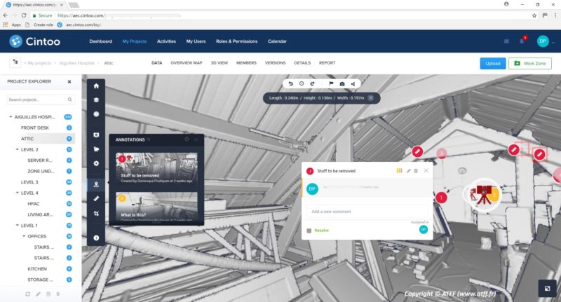
Cintoo makes it easy for users to add annotations to the surface models.
Cintoo Cloud can also handle BIM models for side-by-side comparisons with your scans. Very soon, it will be able to connect to your BIM management platform, like BIM 360 or Procore. Users will be able to add annotations directly to the data and see them show up directly in the project review of their BIM management tool.
That’s not even the clever part, says Pouliquen, since “the transformation we did at the beginning, which turns the point cloud into surfaces, can be mathematically inverted.” This means that the Cintoo Connect desktop app can turn the mesh back into a point cloud. During this transformation back to the point cloud, the data maintains an .e57 format, along with all the necessary structure information. Furthermore, you can output the point cloud at the density and accuracy you need. This makes the data quick to transfer, but also easy to work with in BIM modeling applications, the majority of which are still not configured to work well with mesh data.
Better 3D data organization
When the scan-to-BIM user views the 3D data on the cloud service, Pouliquen says, he benefits from 20+ years of technological development in 3D data organization and visualization.
First, the software offers an organizational scheme that allows an administrator—like a BIM manager—to view each individual scan, and then organize these scans into work zones for easier access. It’s as simple as clicking on the scan location and organizing them into levels, rooms, or whatever unit makes the most sense.
The BIM modeler benefits greatly from this arrangement, since not only is he downloading compressed data, but also a much smaller set of scans. “You know when you import too many point clouds into Revit, performances may be affected,” says Pouliquen. “So what you bring back into the modeling app after using Cintoo is only a subset of the total. On a project of 500 scans, organized into rooms and levels by the BIM manager, a modeler needs to access just 20-30-50 scans. Of course, this will be much faster than downloading 500 scans.”
Better 3D data viewing
When a user opens a work zone, they will see what looks like a classic point cloud overview. However, Cintoo’s innovation here is that it offers a dynamic overview that shows different amounts of detail depending on how far the user zooms in, and how fast the user’s internet connection is. This ensures very fast, high-detail visualization—as I sat in Portland, Maine, Pouliquen demonstrated this function over a GoToMeeting connection from San Francisco, where he was streaming data from The Netherlands. Cintoo never skipped a beat.
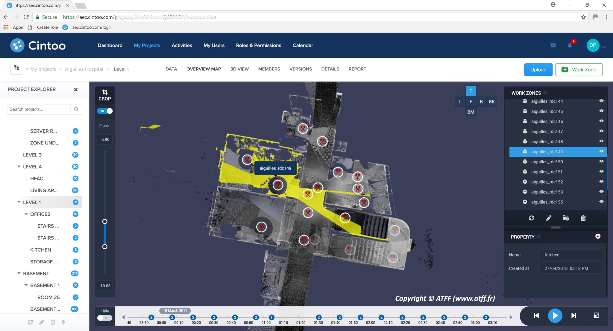
Cintoo’s overview map view. Red dots represent scan locations, and yellow triangles represent scan coverage.
For easier viewing, users can also crop the data along any axis, even when comparing a point-cloud derived mesh to a BIM model. Pull the crop down along the z axis, for instance, and Cintoo will crop the surface model and BIM model at the same time. If you’re looking for a specific piece of information, you can use the crop function to find it quickly, and then export it as a 2D floor plan for quick reference in your BIM modeling workflow.
Cintoo offers a few other useful visualization functions, like chronological sequencing of scans for tracking changes over time, with scan-to-scan comparisons in the pipeline.
Cleaner perspectives
Here’s another way that Cintoo’s surface models improve on the point cloud for BIM modeling: backface culling.
When you view a point cloud of a building, it can often be difficult to see details on the inside of the structure, as they are obscured by the points for the walls or roof. Removing the obscurants in point cloud software is not obvious, says Pouliquen, but Cintoo works with meshes, so it can offer a feature that hides all the polygons not oriented toward the camera. It’s as easy as that—turn on backface culling and you can see the inside of the building, and all the details you need.
Cintoo’s mesh-based approach offers one more unexpected benefit for users of panoramic views. When you capture a panorama using a camera, Pouliquen explains, sometimes you end up with areas that are over- or under-exposed, making it difficult to discern the details you’re looking for. Since Cintoo retains all the structure information in the files it converts to mesh, it allows users to view the depth data where under the RGB data that has been under or overexposed. Uses can make as many panoramic views as they want, directly within the software. This ensures that you can see everything you need.
Coming soon
Considering how feature-packed Cintoo’s solution is, you won’t be surprised to know that there is already a lot more in the works. Pouliquen says Cintoo is planning to bring in more VR and IoT support, as well as a variety of web services, which will perform tasks like AI-enabled segmentation, classification, and specification, as well as automatic checks for planarity.
As Pouliquen puts it, Cintoo aims to offer everything you need for an easy scan-to-BIM workflow.
Cintoo will be on hand at SPAR3D this year demonstrating a beta version of its solution, as well as giving full VR demos in their booth. The product is expected to launch officially this fall.


