The technologies enabling bathymetry have rapidly evolved in the last several years, allowing the science of mapping underwater terrain to advance significantly. Sonar, topographic and bathymetric lidar can now be brought together to paint a clearer picture than ever before, enabling bathymetric data to become a cornerstone for understanding and managing our coasts and rivers. As climate change, infrastructure needs, and disaster events continue to increase demand for high-quality data about coasts and waterways, companies like NV5 are finding ways to blend decades of experience with cutting-edge technology. The results are actionable insights that reveal what is below the water surface.
NV5 has been a pioneer in bathymetric mapping, with their teams bringing a wealth of experience in both data analysis and field operations. Their work includes managing fleets of aircraft and sensors to develop advanced analytics for clients like NOAA and the USGS. Geo Week connected with Mischa Hey (Analytics Practice Lead, NV5) and Scott Venables (Account Manager, NV5) to get their reflections on where the technology and applications of bathymetry are headed, and why the insights this technology provides are so important.
Going beyond the lasers
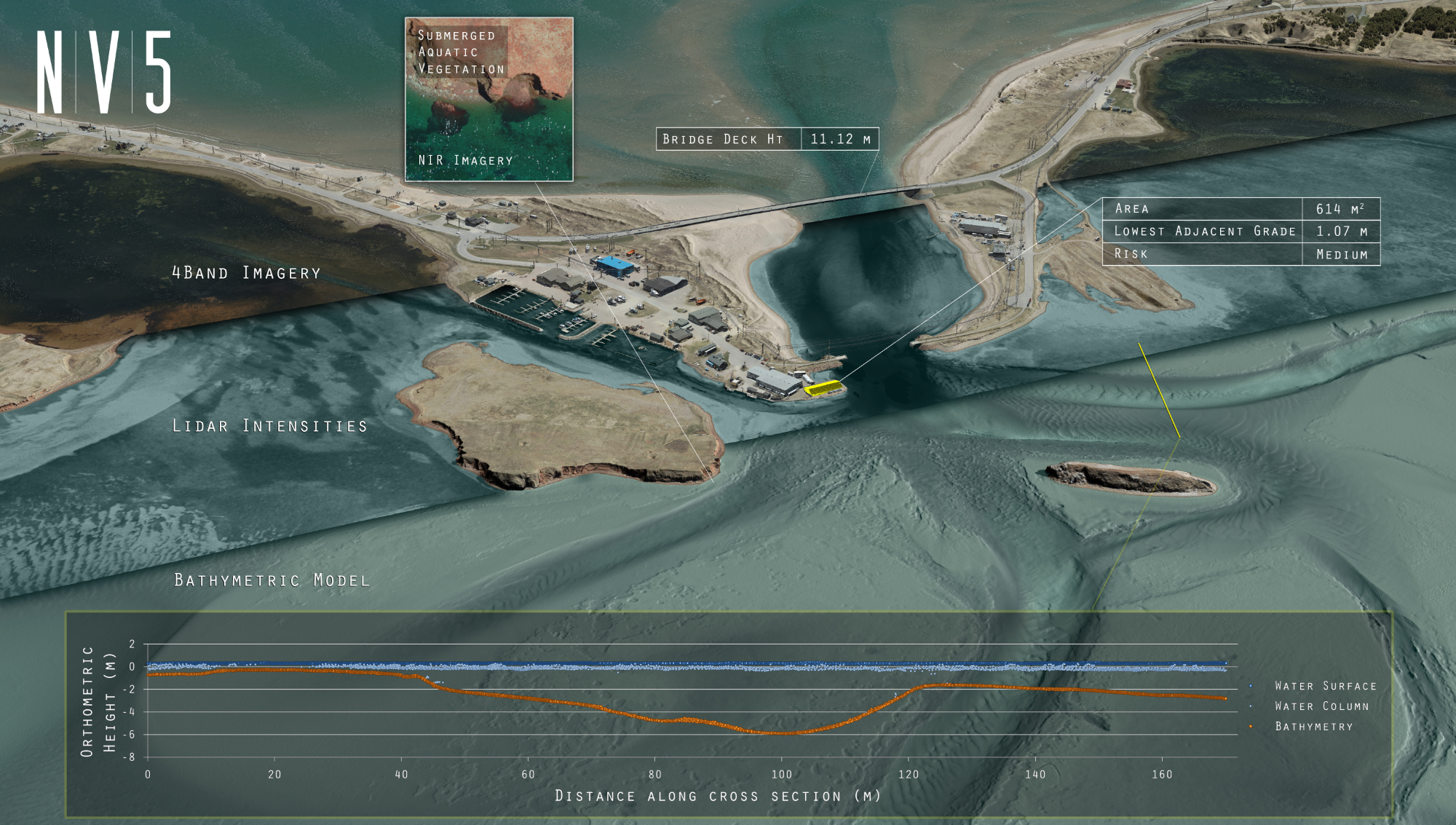
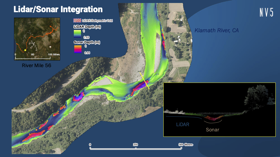
NV5’s work covers a spectrum of applications. In coastal zones, they integrate airborne lidar and sonar to map everything from shallow nearshore environments to deeper offshore areas. This hybrid approach allows for efficient identification of features like shipwrecks, coral heads, and seagrass beds, and supports targeted, high-resolution surveys where needed for coastal zone management. In riverine environments, NV5 helps clients model flooding, analyze habitat features such as large woody material, and track geomorphic changes over time.
Collecting this data, however, is not without major challenges. When we asked what they thought everyone should know about what it is like to do bathymetric data collection, they had a very straightforward answer: It’s hard.
“Everything about bathy is more difficult, more complex, and requires greater tuning of the processing approach than traditional Near Infrared (NIR),” said Hey.
While it remains a difficult pursuit, there have been a lot of encouraging changes. Recent advancements in lidar and sonar technology have significantly expanded the capabilities and efficiency of bathymetric mapping, including improvements in pulse rate and signal processing. These advances have enabled the collection of more data points with greater accuracy, allowing for higher resolution mapping of underwater features. But as Hey explains, it isn’t just a matter of getting higher-powered lasers to get better returns.
“A lot of it comes down to the signal processing like waveform averaging- because there are limitations in how much you can crank the laser up without introducing eye safety concerns,” said Hey, because the laser is operating with visible wavelengths. “You can’t just increase that power to get more depth; it comes down to increasing point density by leveraging context and adjacent pulses, to get higher confidence in low amplitude returns.”
As such, NV5 is always looking at the latest in sensors, software, processing, lasers, and other technological developments to make sure that they’re able to get the most out of what they can collect and get the best insights they can for their clients.
New form factors provide new versatility
The evolution of sensor form factors has also played a crucial role in what can be accomplished with bathymetric lidar. Lidar systems traditionally required large, airplane-mounted equipment, but new compact sensors can now be deployed on helicopters or even drones, making it possible to access challenging environments and collect data more safely and efficiently.
“Going back a few years, your only option was putting a sensor in an airplane,” said Venables, “You’re now talking about putting a bathy sensor on a helicopter or even a drone and opening up more markets and new players in that game too.”
NV5’s adoption of small form factor bathymetric scanners exemplifies this shift, enabling safer and more precise mapping in challenging environments. Recently adding helicopter-based sensors to their fleets has been game-changing for river and corridor mapping, explains Venables.
“It mixes up the fleet of aircraft you need and opens up more doors and possibilities. We’re using a helicopter to fly in a lot of riverine environments - we have a lot of terrain out here in the Pacific Northwest and that can be tough to safely navigate an aircraft at the altitude that you’d need to collect bathymetric data. The helicopter opens up those headwater systems and allows you to target the ideal flying height, and also increases your efficiency because now you can start focusing more on the river itself.”
In addition to being an improved means for navigating difficult-to-reach areas, the collection from “slower” platforms is also denser, which can lead to better feature detection and classification over previous aerial methods, explains Hey.
“You’re able to actually track the meander, and you end up with a smaller spot size when you’re flying lower. It may be less efficient for flight time with a slower aircraft, but because you don’t have to fly in straight lines, it can actually be a way more efficient, or sometimes the only way, to get good data in canyon environments.”
Sensor integration helps reveal cause and effect
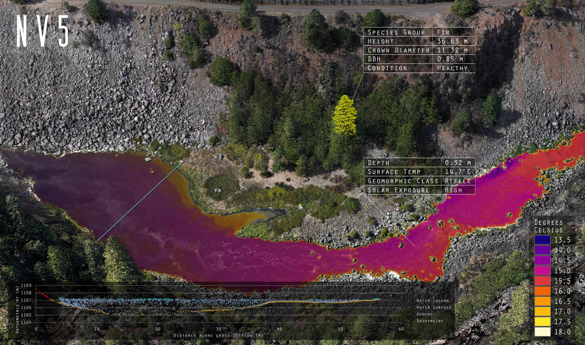
The integration of multiple sensor types, such as combining green channel lidar with NIR and RGB imagery, is opening up new avenues for creating comprehensive digital models of coastal and riverine systems. These technological leaps are not only increasing the quality and quantity of data collected but are also enabling new applications and insights that were previously out of reach.
“The more we’re tying imagery, NIR, bathy lidar together in single systems, that lets us generate digital twins for these types of applications in far more efficient ways. You can use one dataset to inform the analysis of another,” said Hey.
“We’ve also got the capability to put a couple of RGB cameras in there, as well as a FLIR long wave infrared, so you can then tie in thermal data to the bathymetric lidar data,” says Venables, “That multimodal collection opens up application use cases supporting identification of additional patterns and relationships. You’re able to understand more about causation than simple correlation of features.”
Better data for a complex future
As the demands for resilient infrastructure, climate adaptation, and ecosystem management continue to grow, bathymetric mapping is becoming a crucial tool for decision-making. By blending decades of expertise with the latest in lidar, sonar, and sensor integration, NV5 is helping agencies and organizations uncover what lies beneath the surface and understand how those hidden landscapes shape the world above.
With innovations in form factors, processing, and multimodal data collection, the possibilities are only expanding. The ability to merge coastal, riverine, and offshore insights into integrated digital environments is transforming how scientists, engineers, and policymakers approach complex challenges.
As Hey put it, "The advancements in bathymetric technology and sensor integration allow us to leverage the concept of digital twins in aquatic systems which is very exciting. The better these sensors get, the more we’re able to learn.”