

The YellowScan Navigator is a new bathymetric lidar system that enables surveyors to map underwater topography, in rivers, ponds and coastal areas. The system is the result of a development phase of five years, and has been heavily tested to achieve optimal performance. It was developed inhouse by YellowScan, a lidar solutions provider from France. The Navigator is the company’s first bathymetric system and extends its current product portfolio of UAV lidar hardware and software.
Bathymetric lidar is based on visible green light emission that enables the measurement of topography underwater. Bathymetric lidar systems enable mapping both waterbed and land, a mandatory task for monitoring, modeling, and mitigating coastal erosion, flood hazards and understanding biodiversity habitats. New workflows and capabilities of bathymetric lidar are the result of recent innovations in lidar sensors. This and more is explained in a recent report from Geo Week News called “Beyond the Surface: Lidar Advances in Bathymetry,” available here.
System specifications
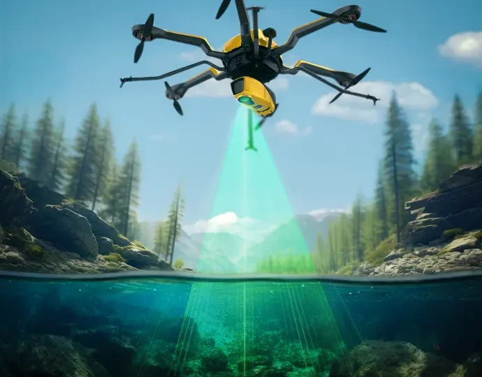
The Navigator bathymetric lidar system weighs 3.7kg (battery weight excluded), which allows for quick deployment on a multirotor or helicopter UAV, facilitating surveys of non-navigable areas and covering a larger surface area in a single pass compared to traditional methods. It is optimized to map waterbeds within a depth range of 0 to 3 meters, but reaches a depth of 18 meters in perfectly clear water conditions. It can be flown up to 100m above the water surface and provides measurements with a precision and accuracy of 3 centimeters. Additionally, a camera is embedded to provide true-color data colorization.
Because the Navigator is a waveform lidar system, continuity between underwater points and the surrounding terrain is ensured. With a 44-degree field of view, precision is prioritized over a broader angle. On YellowScan’s Navigator product page, it is explained that this decision is based on the fact that 44° is the maximum angle for a green laser to perform effectively underwater, while beyond this angle, the laser’s penetration depth in water is significantly affected, which limits the system’s overall performance.
Software integration
The system is integrated with YellowScan’s CloudStation software, providing underwater point correction refining submerged data points, taking into account water refraction and ensuring reliable bathymetric mapping with uncompromised accuracy. The software also includes automatic water classification, which streamlines the categorization of water bodies, enhancing the efficiency and precision of bathymetric mapping. The capability for automated water surface detection efficiently identifies water boundaries, streamlining data analysis for precise bathymetric mapping.
Applications
Additional resources
YellowScan announced the Navigator at CES 2024 in Las Vegas, and the system will be on display during the Geo Week even during Feb 11-13 in Denver at booth #926. An extended list of the Navigator’s product specifications is available online, as well as a recently acquired sample dataset. A dedicated page about YellowScan’s lidar platform integrations is found here. A short product video is found here.


