
Why Hexagon made the buy and where they go from here
WEST KELOWNA, British Columbia – Unlike in some cases where smaller software companies are bought by larger ones, like that of Alice Labs by Autodesk, MicroSurvey will not be subsumed into Hexagon or any of the company’s brands.
“I’m still here,” said MicroSurvey president Darcy Detlor, “still running this company as I’ve been doing for 25 years or more.” (Detlor founded the company while still a student at the University of Alberta, to make up for student loans that didn’t come through.)
“First and foremost,” agreed Ken Mooyman, president of Hexagon Geosystems, NAFTA, in a separate interview, “we want MicroSurvey to continue the business model they’ve been successful with … MicroSurvey is absolutely the brand. There’s been no discussion of changing that.”
“I’ve been tasked to continue doing what we have been doing because we’ve been making money and we’ve been growing,” Detlor said, noting the company recently surpassed 100 countries in which it has customers. He said MicroSurvey’s licensing of Leica’s Point Cloud Engine, the OEM versions of MicroSurvey’s software that have been built for others of Hexagon’s brands, and simply the experience of working with their people made the acquisition a good fit for both sides.
“It’s aligned with my goals,” Detlor said, “which is to insure that we have the widest possible distribution for our products. That’s been the number one problem for us: Just not enough distribution. We’re not unique as a software company that way, but I think our products have been a lot better than our distribution capabilities.”
But won’t moving from being an independent company to one that’s part of a conglomerate with many competitors actually hurt the company’s chances for increased distribution?
Not at all, Detlor said. “Our mandate is to sell our product to anyone we can,” he said. “We’re actually dealing with almost 20 OEM partners around the world, and there’s been way more feedback from people who were worried we wouldn’t deal with them anymore than feedback from people who didn’t want to deal with us.”
He likened his position to that of NovAtel’s, a GNSS product manufacturer Hexagon bought in early 2008. “They’re independent out in Calgary and they sell to everyone they can,” Detlor said.
Mooyman backed up that position. “There are a lot of competitors to the Leica brand – like FARO, some of the Chinese manufacturers – that are important to MicroSurvey,” he said. Nor will Leica’s relationship with its partners be affected, he noted. For example, in the forensics marketplace, the Leica team has been recommending software by The CAD Zone along with MicroSurvey’s MapScenes. This will continue.
“In fact,” Mooyman said, “we worked very hard with the CAD Zone team before the acquisition and since to make sure that we secured that relationship so that we can continue to offer this broader software offering.”
However, Hexagon will certainly look to improve MicroSurvey’s distribution and introduce it to a wider audience. As the company looks to bring its GeoMax brand of positioning products to North America, for example, “we’re not going to be offering the Leica software with that,” Mooyman said, “so we need to offer third-party software. That will be MicroSurvey, along with Carlson and others if customers require it.”
Most important overall, said both Mooyman and Detlor, is that anyone using sensors – laser scanners, GPS, total stations, etc. – have an easy way to process the data they’re collecting and quickly generate the deliverable their customers want.
“We need to continue to bridge that gap between the sensor and the CAD/GIS software,” Mooyman said, “and that’s exactly where MicroSurvey fits … People might ask, ‘Why MicroSurvey when you have Intergraph?’ Well, we need to find a way to get our sensor data in there more efficiently and MicroSurvey helps with that.”
“We intend to have the smoothest, most pain-free, workflow in the industry,” Detlor said. “That’s our goal. So we’ll be mixing in all the different types of sensor data that [customers]have: total stations, GNSS, or point cloud information. They all should be in the same package, so we’ll be working on that this year with products to release this year.”
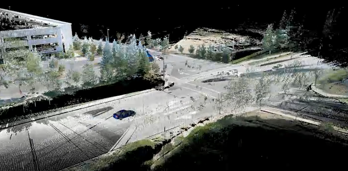
He said MicroSurvey already has some unique abilities that make for smooth workflow, including the ability to animate CAD within point clouds. Say you’re a police officer investigating a crash at an intersection; you can just scan the intersection, and “the scan becomes the model,” Detlor said. “Then you just drive the vehicles through the model and simulate what they’re going to do, and you make a video of it for the jury or the court. It removes a huge amount of manual work in creating the CAD model for the drawing.”
Or, in a plant environment, you can “take a very complex CAD entity and animate how it moves through a tight space using just the point cloud, with moving cameras and multiple cameras and key-frame-based animation.”
Take that, he said, and combine it with full survey and geometry calculations, surface modeling, and more, and “you’d have to buy three or four different packages to replicate all of that,” Detlor argued, “and learn three or four packages. That can be agony.”
Further, he predicted these tools would only become more necessary for the typical surveyor or investigator. “I think within five years every [survey]crew will have some kind of scanning capability,” he said. “If they don’t, they won’t be competitive.”


