Survey technology developer Maptek will demonstrate the power and simple workflow of I-Site™ Studio software for processing and modelling airborne data at this week’s lidar mapping forum in Denver, Colorado.
By their very nature, datasets captured by UAVs and other aerial methods are large and often cumbersome to work with. Tools in I-Site Studio readily convert this point cloud data into practical digital deliverables.
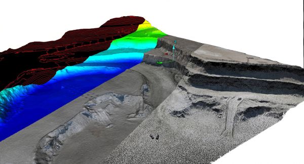
‘I-Site workflows streamline the path from dense lidar data to useful output,’ said I-Site Engineer Clayton Fritz from Maptek™. ‘Intelligent filtering options are the first step in making the file size manageable.’
‘Minimum point separation filters extraneous points without sacrificing detail. Users can also choose to keep the lowest points and screen out vegetation so an accurate, unobstructed topographic surface is the result. Accuracy is not lost for modelling surfaces and calculating volumes.
‘If point data is the required deliverable, then there’s nothing simpler than bringing the data into I-Site Studio, filtering to a size that can be managed by other programs and exporting the point cloud dataset.’
I-Site Studio allows surfaces to be exported as multiple different file types. Contours and sections can be generated with one click. Interactive CAD tools mean that geometry can be drawn directly onto data. Users can swap between views during editing.
Breaklines (also called toe and crest strings) are automatically generated for easy definition of mining faces and input to mine planning.
‘As aerial devices become more affordable for mapping extensive operations, users need multi-layered software to manage their data. I’m looking forward to showing ILMF visitors why I-Site Studio should be their software of choice, outperforming traditional methods in flexibility and power,’ concluded Fritz.
Watch the video to see the benefits of I-Site Studio in handling UAV data.
About Maptek
Founded over 30 years ago, Maptek™ is a leading provider of innovative software, hardware and services for global mining. Maptek products are used at more than 1700 sites in over 70 countries, with solutions across the mining cycle from exploration to reclamation. Vulcan™ is one of the longest standing 3D mine planning and modelling packages. I-Site™ is integrated hardware and software for 3D laser scanning, surveying and imaging. PerfectDig provides a platform for design conformance. BlastLogic™ is intelligent 3D drill and blast management software. The Eureka™ environment is ideal for visualising and interpreting geophysical and seismic data. Sentry is a laser-based system for identifying trends in surface movements. Evolution provides strategic and tactical scheduling and optimisation tools.