
To coincide with ILMF, SBG Systems has announced their new Apogee line of inertial navigation systems, their first MEMS-based INS accurate enough for high-grade survey applications like hydrography, mobile mapping, and aerial survey. In a release, the company touts the Apogee line as being capable of achieving 0.008 degrees in roll and pitch in real time, and 0.005 with post-processing.
In conversation with SPAR, SBG Systems CEO Thibault Bonnevie also emphasized that the Apogee products were developed with budgets in mind. While achieving a high level of precision, he explained, the Apogee products are also smaller and more cost effective than the industry average, which helps to make mobile mapping platforms more affordable for their customers to assemble.
The price drop for INS was necessary, Bonnevie explained, to match the falling prices of other mapping technologies. “LiDAR prices started to go down a few years ago,” he said, “and now INS are sometimes more expensive than the LiDAR. The Apogee is going to follow this price trend, which will help to open up new markets such as UAV LiDAR.”
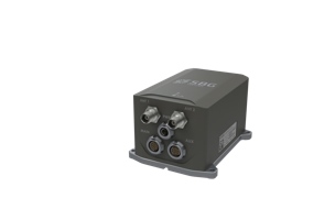
In fact, the UAV market seems like an ideal segment for the Apogee products. For one, as Bonnevie said, the Apogee benefits from “its integration as an all-in-one system that includes in one box the IMU, the GNSS, the processing and recording. This significantly reduces the integration cost and effort for our customers.”
“As a bonus,” he continued, “the power consumption of our higher model, the Apogee-D, with its dual-antenna GNSS receiver is as low as 7W.” When often an INS will draw as much as 20W, this low power consumption translates into more acquisition time for the operator on each battery pack, saving man hours and money.
Though SBG has already made significant inroads into the market customers that take a “build-your-own” approach to finding the perfect mapping solution, Bonnevie told SPAR, the Apogee looks to offer that same option to customers who perform advanced ground and aerial surveys. As he explained, SBG has experience working with customers who matched their Ekinox middle-range INS with Velodyne LiDAR, and the company is positioning to Apogee to offer higher accuracy in similar configurations.
In order to achieve this mixture of survey-grade accuracy, size, weight and power consumption at a highly competitive and affordable price point, SBG Systems controls the full INS manufacturing process from conception to production. Bucking the industry trend, SBG designs their own IMUs to hit the right balance of accuracy and cost. “We can then pair the perfect sensors together for our targeted application,” Bonnevie says. “What is the need for 800°/sec or 10g sensor ranges for survey application, when you will probably never exceed 100°/sec and 2? Buying an IMU costs a lot more than designing our own if we are able to scale the production.”
“The main benefit of all this,” Bonnevie concluded, “is the cost of the solution. One box, IMU, GNSS, processing and storage reduces cost and integration effort for our customers.”
Stay tuned for more news from ILMF.


