
Shepperton Studios, 23 March 2015 – Arithmetica is launching a brand new version of its automated point cloud processing software. Pointfuse Pro includes new 2D tools that allow for the creation of plans, elevations and sections from highly detailed laser scan data as well as orthorectified images. Pointfuse also includes support for a much wider range of raw data, including a new open standard file format, and for data generated by handheld laser scanners that are set to revolutionise the construction industry. Pointfuse Pro also includes new functionality that allows users to understand the accuracy of resulting vector models created from the laser scanned data.
Pointfuse will be demonstrating these new features at SPAR International. The 3D measurement and imaging conference and exhibition taking place from the March 30th to April 2nd in Houston, Texas.
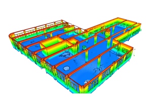
Pointfuse Pro includes a range of new functionality with the software’s 2D tools. These includes the ability to generate orthorectified images from the point cloud which can be scaled and used as layouts for final delivery in a range of other CAD, desktop mapping and GIS packages. The new 2D tools also allow for the production of plans, elevation and sections as line work for applications such as architecture, facilities management, surveying and construction. In addition to the new 2D tools, Pointfuse Pro also includes new accuracy reporting tools. This functionality allows the user to define project tolerances and, based on the standard deviation statistics, Pointfuse can visualise the accuracy of the vector model by colour coding the created surfaces.
Pointfuse Pro now supports an even wider range of laser scanned data formats, including the DotProduct format and E57. DotProduct uses off the shelf Android Tablets for high resolution handheld 3D laser scanning. Designed for engineers and others working in the construction industry, this offers a lightweight, cost effective solution for laser scanning in challenging environments. E57 is the open standard file format for 3D imaging data exchange, and is capable of storing point cloud data from laser scanners and other 3D imaging systems, as well as associated 2D imagery and core meta-data.
Pointfuse is a powerful modelling engine developed by Arithmetica, a hi-tech company based at Shepperton Studios. Pointfuse gives professionals an astonishingly fast, precise and flexible way of converting the vast point cloud datasets generated by laser scanners or photogrammetry into high fidelity vector models. Designed for engineers, architects and construction professionals, Pointfuse uses advanced statistical techniques to create vector models which can then be manipulated using any industry-standard CAD system.
Uniquely, Pointfuse is fully mobile compatible, and can process data from mobile scanners as easily and quickly as from terrestrial or airborne systems – and its results can be output and used on standard handheld mobile devices for use in the field.


