
November 20, 2014 — Optech is pleased to announce that it will attend the Asia Geospatial Forum 2014 being held from November 25 to 27 in Jakarta, Indonesia. At the forum, Optech will be showcasing several new technologies, plus greater accessibility to a well-known system already in use by various government agencies. If you are attending this event, you are invited to pass by Optech booth 25 and learn more about the greater efficiencies, lower operational costs, and additional data deliverables made possible by the latest Optech developments.
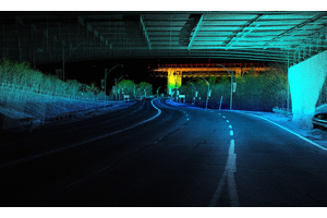
Airborne surveyors needing greater collection efficiency will be amazed to see what Optech Galaxy and its PulseTRAK™ technology can do for them. Finally, an airborne lidar system that minimizes gaps while maintaining data quality and coverage consistency over extremely varied terrain and infrastructure heights.
For those looking for a multi-purpose sensor system ideal for resource management, forest inventory, environmental modeling and even shallow water bathymetry data day or night, be sure to stop by our booth to learn more.
As sea levels rise, a thorough understanding of the near-shore environment is crucial for mitigating disasters, monitoring the environment, and protecting infrastructure. Pan Asia Regional Sales Manager David Collison will present a paper by Software Development Manager Dr. Joong Yong Park titled “Ocean & Coastal Observation Using Airborne Systems”. The presentation will compare airborne lidar bathymetry to ship-based sonar, and discuss the situations in which airborne surveying is the more efficient option. Mr. Collison will also discuss how to improve coastal surveys by using airborne bathymetry data to cross-check Aqua-MODIS satellite imagery and water absorption/scattering field measurements. He will provide details on how local governments, academic institutions and surveyors can leverage the new CZMIL Project Program to access the advanced turbid water and 80 m clear water capabilities of the Optech CZMIL airborne lidar bathymeter without actually purchasing the system. The program includes the HydroFusion workflow software, and a staff of trained personnel to take users through the project from planning to finished product.
More details about Galaxy and the CZMIL Project Program will be available at Optech booth 25, along with information and news about Optech’s other airborne lidar and camera systems, mobile mappers, and terrestrial laser scanners.
About Optech
Optech is the world leader in high-accuracy lidar 3D survey systems, integrated cameras, and productivity-enhancing workflows. With operations and staff worldwide, Optech offers both standalone and fully integrated lidar and camera solutions in airborne mapping, airborne lidar bathymetry, mobile mapping, terrestrial laser scanning, mine cavity monitoring, and industrial process control, as well as space-proven sensors. Accuracy and productivity matter!


