An investment in a Leica ALS70-HP LIDAR system and RCD30 camera positions the aerial surveying firm to provide a faster turnaround on innovative mapping solutions.
NORCROSS, GA, OCTOBER 22, 2014 –  Leica Geosystems Inc. today announced that ATLIS Geomatics, an aerial surveying and photogrammetry firm based in Winnipeg, MB, has invested in a Leica ALS70-HP LiDAR system fully integrated with an RCD30 camera. The combined solution will provide the firm with the accuracy and efficiency needed for both small engineering projects and wide-area mapping work.
ATLIS Geomatics was founded nearly 20 years ago by Mark Brooker and Diane Brooker as Aerial Technologies & Land Information Services, with a focus on photogrammetry. “As we continue to grow, we wanted to have more control over the data collection by owning LIDAR sensors,” said Daniel Brooker, vice president of business development for ATLIS Geomatics.
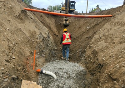
The firm had already been relying on data from the Leica ALS70-HP as a standard in its LIDAR mapping projects. The 500 kHz airborne laser scanner has a high pulse and scan rate and enough laser power that it can be used at high altitudes for general-purpose airborne mapping. The Leica ALS70-HP also has the ability map at lower altitudes, which enable it to quickly generate very high density point clouds for corridor, urban and flood mapping applications.
The integration of the Leica RCD30 camera with the Leica ALS70-HP was a key factor in Atlis Geomatics’ investment decision. The 80-megapixel camera collects four band, multispectral imagery from a single camera head and is co-registered with the LIDAR data to provide greater value in a LIDAR dataset for planimetric and topographic mapping.
“In the past, acquiring both LIDAR data and photogrammetry would have been cost-prohibitive for most projects because it would have required multiple flights with extensive processing,” Brooker said. “With the Leica ALS70-HP and RCD30 solution, we overcome that hurdle by collecting high-quality LIDAR data and multispectral imagery on the same flight with a fast turnaround, giving our clients substantially more value from their data investment.”
Within the first week of using the new airborne sensors, the company collected almost 6,000 square kilometers of LIDAR data. “The quick and trouble-free installation greatly reduced our downtime and had us operational very quickly,” Brooker said. “Wasim Noor (Leica Geosystems airborne systems support engineer) was an incredible help. We can’t wait to continue to expand our relationship with Leica Geosystems.”Â
Shawn Slade, who handles sales of aerial digital cameras and LiDAR systems for Leica Geospatial Solutions, said ATLIS Geomatics is perfectly positioned to provide the market with innovative mapping solutions. “ATLIS Geomatics is a recognized market leader in photogrammetry,” he said. “Adding high-efficiency LIDAR combined with high-quality multispectral imagery gives the firm new opportunities to bring value to its clients.”
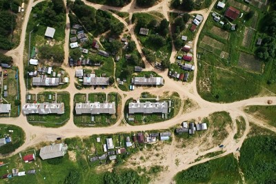
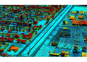
Image: The integrated Leica ALS70-HP and RCD30 solution collects high-quality LIDAR data and multispectral imagery on the same flight. Image courtesy of ATLIS Geomatics.
For more information about ATLIS Geomatics, visit www.atlisgeo.com. For more information about Leica Geosystems airborne sensor solutions, visit www.leica-geosystems.us.
Leica Geosystems – when it has to be right
With close to 200 years of pioneering solutions to measure the world, Leica Geosystems products and services are trusted by professionals worldwide to help them capture, analyze, and present spatial information. Leica Geosystems is best known for its broad array of products that capture accurately, model quickly, analyze easily, and visualize and present spatial information.
Those who use Leica Geosystems products every day trust them for their dependability, the value they deliver, and the superior customer support. Based in Heerbrugg, Switzerland, Leica Geosystems is a global company with tens of thousands of customers supported by more than 3,500 employees in 28 countries and hundreds of partners located in more than 120 countries around the world. Leica Geosystems is part of Hexagon, a leading global provider of design, measurement and visualization technologies that enable customers to design, measure and position objects, and process and present data.
For further information please contact:
Leica Geosystems Inc.
Andre Ribeiro
Vice President, Marketing and E-Commerce
Atlanta, GA 30092
Phone:Â +1 (770) 326-9557
Fax:Â Â Â Â +1 (770) 447-0710
[email protected]
www.leica-geosystems.us