Reality capture is at the core of how infrastructure connects to the geospatial world, and it's getting more precise and dynamic by the day. This shift isn’t just about better scanners or faster software – although the advances here are immense – it’s about creating intuitive workflows and democratizing technology so that precision becomes accessible to all.
Simplicity meets scale
For years, reality capture workflows were complex and siloed: data collected in the field, processed in the office, then analyzed days – or even weeks – later. This simply doesn’t cut it today. Advances in hardware and software mean verification can happen in real time, on site, by a single operator. This isn’t just a technical upgrade – it’s a practical one. When data flows seamlessly from instrument to cloud to BIM platforms, decisions happen faster, errors are caught earlier, and projects stay on track.
But speed means nothing without precision. Transforming reality into numbers only works if those numbers are accurate from the start. Poor-quality data creates inefficiencies throughout the workflow, which is why the industry is moving from raw capture to integrated, unified processes that prioritize precision and usability.
Smarter sites, smarter tools
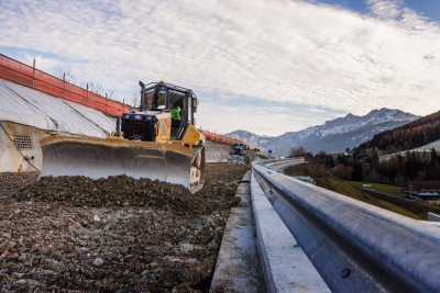
New generations of scanners and mobile solutions are putting high-precision capture in the hands of more professionals. Portable devices, such as the new CR-H1 by Topcon, leverage photogrammetry via smartphones, making it possible to do utility and subsurface mapping, verify as-built conditions, and capture complex geometries without specialist crews. But these tools only deliver their full potential when paired with upgraded workflows.
Moving forward, having a single, cloud-based workflow won’t just be helpful; it will be essential. Without it, teams end up working with disparate systems and fragmented data sets that cause delays and errors. By pulling data from every instrument into one ecosystem, there’s no need to juggle licences, waste hours converting and transferring files, or wait on data analysis.
Instead, the data captured in the field moves straight to the cloud, ready for visualization, analysis, and integration with BIM platforms. The payoff is huge – real-time verification on site, faster decisions, and far less risk of costly rework. It’s about confidence as much as speed, because when everything lives in one connected workflow, you know the information you’re working with is accurate and accessible the moment you need it.
The applications are compelling. Utility mapping, for example, benefits enormously from handheld capture integrated with cloud workflows, reducing the risk of costly clashes, and improving safety. Tunnelling work is also seeing gains thanks to processes that link field data across major industry platforms.
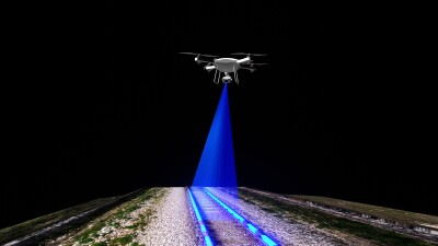
Beyond the point cloud
As workflows evolve, so does visualization. Gaussian splatting complements traditional visualization methods by offering smoother, client-friendly 3D models that improve clarity for stakeholders with lighter data sets. It’s a valuable alternative for projects where visualization matters most, but LiDAR remains the gold standard for tasks demanding the very highest levels of precision.
For both, mass data capture is key to creating digital twins and enabling smart cities – connecting these precise datasets with building information modelling technologies in construction. It’s about choosing the right tool for the job and making sure this data is universally accessible.
At the same time, AI is enhancing reality capture workflows. From automatic feature extraction to predictive analytics, machine learning is turning point clouds into actionable insights. But these learnings need to come from rich real-world datasets to be practical, trustworthy and actionable.
Adoption, accuracy and the road ahead
If reality capture and seamless workflows are so powerful, why aren’t they being used across the board? The barriers aren’t technical – they’re cultural and educational. Firms need confidence that innovation won’t disrupt productivity. That means training, continuous learning, and support from manufacturers who understand that technology adoption is a journey.
As this evolution continues, two principals remain unchanged: precision is paramount and surveyors must maintain integrity in mapping. Technology can do the legwork and simplify workflows, but it cannot replace professional judgment, or the expertise people offer at every stage of construction.
The businesses that thrive will be those that embrace simplicity without sacrificing precision, upgrade entire workflows rather than patching old ones, and invest in the skills that turn data into decisions. The opportunity is clear: a connected, data-driven future where every project is built on trust, transparency, and technology.
Written by: Neil Vancans is an experienced leader in the surveying and geospatial industries and head of Topcon’s Geomatics Sales Unit. Neil has a wealth of experience in senior leadership roles at companies including Leica Geosystems, Thales Navigation, Septentrio, and Altus Positioning Systems.
In his current role at Topcon, Vancans is responsible for growing the company’s geomatics sales operations globally. His focus includes turning raw positioning data into actionable intelligence, empowering partners and dealers, and accelerating digital transformation through geomatics technologies.