


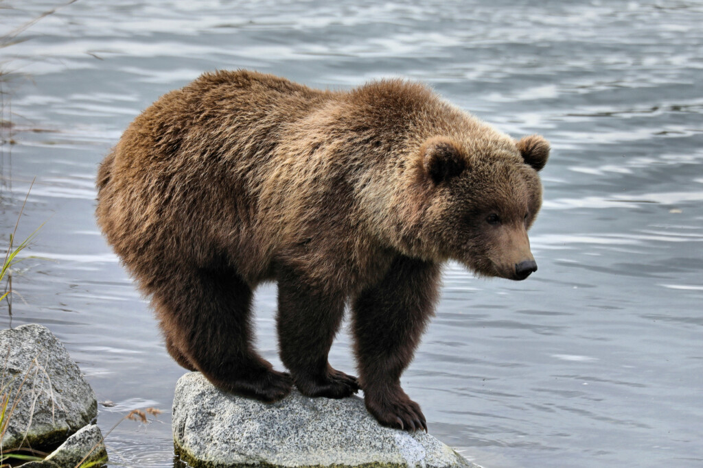
“Fat Bear Week celebrates fatness. That’s what you want to do before you go into your den.” Each year as summer begins to fade and wildlife begins to prepare for the long Alaskan winter, Katmai National Park holds an annual voting contest known as Fat Bear Week, in which the general public votes on their favorite fat bear of the season, with contests for both junior and adult brown bears. The event has gained mass popularity online over the last few years, with nearly 800,000 votes being cast in the 2021 contest. The junior edition of this year’s contest begins on September 29, with the adult side beginning their voting on October 5. The bracket-style tournament is a celebration of the Alaskan ecosystem and these bears successfully preparing for their winter hibernation.
Given that this contest is run via vote, it’s not about who is literally the fattest, or heaviest, bear, but weight is still a big part of the equation for many. Of course, it’s much easier said than done to get a precise weight for these bears. Park officials are able to get an estimate in most years, though, and that’s thanks to the implementation of laser scanners to create estimates. Joel Cusick, a GIS Specialist in the Alaskan Regional Office for the National Parks Service, was the catalyst for this technology being used in the contest, and he was kind enough to spend some time with Geo Week News to talk about how it’s being used, and what doors it could open for wildlife monitoring beyond the fun of Fat Bear Week.
Cusick has plenty of familiarity around many different types of technology, and while making sure to note he is an “ologist,” and not a surveyor, he had used Trimble laser scanners for capturing facilities and other infrastructure around parks. In 2018, he had the idea of trying to scan bears in the park, and that’s how the idea for using this as part of Fat Bear Week originated. He and his team started using a Trimble TX8 scanner for the contest in 2019, and while they were unable to complete scans for this year’s contest for a myriad of reasons, Cusick hopes and expects to utilize it again for future contests. As we’ll discuss below, there are a number of other potential benefits from using lidar scanners for bears.
How to scan a bear
Generally speaking, laser scanners of all kinds are used on inanimate, stationary items, whether they be buildings, bridges, worksite stockpiles, or any of the other many objects we see scanned in this space. That’s a much different, and frankly simpler, task than scanning a living creature, especially one with the capacity to do serious damage. Fortunately, Cusick and his team found a safe way – for both the humans and bears – to complete this process, setting up their scanner on a platform along the Brooks River, home to one of the densest populations of bears on Earth, close enough to complete the scans but far enough away to remain out of harm’s way.
All of these scans are completed with the bears in the water fishing in the river, as this is really the only time they will be still enough for the scans to complete. It’s not an exact science – Cusick notes that the bears need to remain still for three to six seconds, and that out of 10 scans they may get two which are usable – but they’ve figured out a process to get a reasonable estimate. They are able to get a scan of half of the bear, as they can only complete the scan from the platform, but from there can calculate the volume of that half model. The team then doubles their estimated volume, collecting an average from two different team members, and plugs that into a formula taking into account the typical makeup of a bear in terms of water and fat weight. It’s only an estimate, but it’s certainly closer to any other method they’d have to try and weigh these creatures in the wild, and it’s entirely non-invasive to boot.
Challenges around scanning a bear
As mentioned, these scans are usually done to inanimate objects, and while there are still strides being made, many of the potential barriers have been figured out in that realm. That’s not the case with scanning wild animals like bears, a process that brings with it many challenges. Most notably, these are not stationary objects. Bears move around a lot, which is why these scans are all done while in the water. This brings its own challenges with it, most notably that the scanner cannot pierce the water, meaning the scan is generally missing at least part of the bear’s legs, and depending on water level it could miss some of the belly fat as well. In terms of scanning for Fat Bear Week, not getting the belly – where the most volume is on the bear – is a big deal.
In the enterprise and surveying world, a lot of these challenges could be overcome by using other scanning methods beyond a terrestrial laser scanner, but that’s not an option in this case. We asked Cusick about the possibility of using lidar-enabled drones to complete the scans, but he notes regulation issues with that and doesn’t believe that will be possible in a National Park setting. As he says, if you pay to travel out there and take in beautiful surroundings, you probably don’t want a drone flying around to disturb you. We also asked about the possibility of using a handheld mobile scanner, but at least right now these tools don’t have a long enough range to accurately capture the bears without posing major safety risks. Cusick has also been asked about leaving a TLS on a tripod in the woods to potentially capture bears out of water, but that runs a high risk of one of the animals discovering the scanner and destroying a very expensive piece of equipment.
Engaging a Younger Generation
While this is still not a perfected technique for Cusick and his team, there are a lot of potential benefits to this technology beyond simply adding another piece of information for Fat Bear Week voters. One that Cusick is excited about is the potential to better engage and excite the next generations about the majesty of our parks and these animals. In an ideal world, we’d all be able to make the trip and take in these bears in their natural habitat with our own eyes, but we know that’s not possible for everyone. These models potentially provide a way for children in school to see a hyper-accurate representation of the brown bears, and thanks to the team’s georeferencing techniques can even get comparisons of these creatures that otherwise would not be possible. Cusick mentions that one of the goals of the Park Service is to interpret nature, and says that while he'd hate for the younger generation to never come out to the parks, "if you could put [these bears] in a realistic model, like we know that lidar can do, that's a pretty cool, interpretive product."
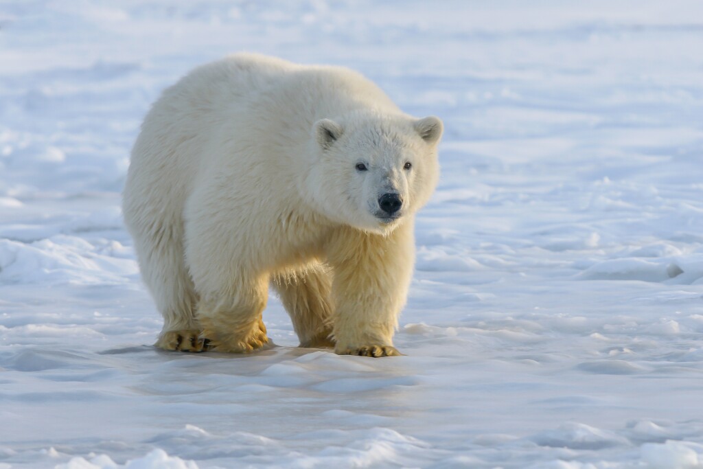
Weighing Polar Bears with Lidar
Perhaps the most exciting potential development from this unique use of laser scanners is how it can be used for wildlife conservation efforts, particular in the arctic. Due to the effects of climate change, conditions on the arctic are rapidly changing, and the extent of the harm being caused to wildlife in the area is unknown. Laser scanning can help, particularly with polar bears. Lindsey Mangipane, a Wildlife Biologist working with polar bears for the U.S. Fish and Wildlife Service, told us that “Body mass has been shown to be an accurate measure of body condition in bears, and can be linked directly to individual fitness.” Currently, the only way to monitor polar bear weight is to dart them from the air and lift them on a tripod to calculate their mass. They would like to find a non-invasive way to track this, and lidar can be that tool.
It should be made clear that this is still very much in the testing phase, but they are currently performing scans on polar bears at various zoos and sanctuaries to test out how accurately they can measure this weight. Theoretically, they could even get more accurate scans than what Cusick and his team are able to get for Fat Bear Week, as it's more feasible to utilize drones and mobile mapping techniques with a scanner attached to a vehicle. On the other hand, there are still challenges that are being figured out, such as whether or not these scans are capturing the polar bear’s hair, and how much that could affect their volume estimates. (For the brown bears, since the scans are being done while the bears are in the river, their hair is matted down by the mist, posing much less of a potential issue.)
Still, the technology is an exciting potential breakthrough for monitoring polar bears in the arctic, with Mangipane noting, “As the climate warms, polar bears are spending more time on land in the fall when sea ice is at its minimum. One potential application of this technology that we are interested in is assessing body condition of bears on land over time. This could provide an indicator of how the bears are doing over time as their habitat changes.” If this methodology proves fruitful, laser scanning could potentially even be used for other animals in other climates as well.
★★★
For now, this technology is being used for the wildly popular Fat Bear Week, and is performing well enough for that forum. Further testing is needed, but the value of this unique usage of laser scanners could be much more wide-ranging.
And, of course, we should note that no bears are harmed in this process.


