Thanks to a combination of better and cheaper technology, climate change creating new global challenges and exacerbating existing ones, and greater understanding of the value it can provide, demand for Earth observation data from satellites is as strong as it's ever been. EOMAP is one company who has long been providing value from this information, with their focus being largely on aquatic information. That includes bathymetry being done with satellites, or satellite-derived bathymetry (SDB), which is a key part of EOMAP’s portfolio. It includes on-demand mapping services and software solutions, amongst which is SDB-Online.

SDB-Online is a cloud-based web app, originally released in 2022, which uses imagery from satellites to create high-resolution bathymetric grids for shallow waters. EOMAP’s physics-based approach to SDB is the key to this offering, which provides quick, high-resolution bathymetric data, and the ability to verify and visualize it. SDB-Online product manager, Mona Reithmeier, took some time to speak with Geo Week News about satellite-derived bathymetry, new updates coming soon to SDB-Online, and which sectors benefit the most from the technology.
What is satellite-derived bathymetry?
Traditionally when we think about bathymetry, we think about collection methods using echo sounders – either single- or multi-beam – attached to a boat to measure depth of water. More recently, we’ve also seen an increase in the use of lidar to take these measurements, typically attached to a plane flying overhead. As Reithmeier notes, though, these more traditional methods can create “data gaps,” such as between the shoreline and where vessels are actually able to take measurements, and – more importantly – the methods rely on intense and costly on-site surveys and relevant equipment. Therefore, it is easily understood that a frequent survey, and surveying of remote or in-accessible sites, is very limited with these methods.
By using satellite-derived bathymetry, these challenges can be addressed. The big advantage of using satellites is the breadth of coverage. Satellites are covering the entire planet on a consistent basis, providing an archive of data going back years to allow for better analysis and monitor seabed dynamics.
At EOMAP, Reithmeier explains, their bathymetry utilizes multispectral satellite data, with spatial resolutions of 0.3 to 10 meters. From there, they use their own patented methodology to calculate water depth. Reithmeier tells us, “What’s happening is that the sun is emitting light through the atmosphere where it gets scattered partly, it goes through the water, down to the seafloor and gets reflected coming up back to the sensor.” EOMAP’s algorithms “invert” that path, allowing them to “calculate water depths for all locations in the world where the satellite records reflection from the seafloor,” creating the physics-based SDB.
How SDB-Online works
As one would expect, it’s this physics-based approach which provides the backbone to EOMAP’s SDB-Online offering. One of the big keys to this solution working the way that it does is its presence on the cloud, allowing for efficient computation speeds at scale, all without having to complete on-site surveys. SDB-Online relies on multi-image processing, allowing users to have faith in their data even in water for which, perhaps, there may be images in which cloud cover can create gaps in the data.
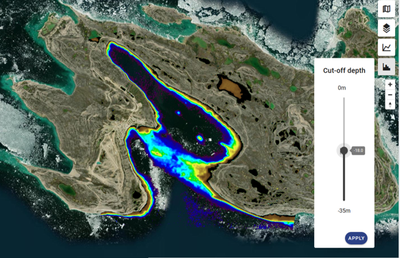
In the new version of SDB-Online being released this month, users can access satellite imagery from selected regions, whether it be a small area or an entire state. Once you have a region with which you are working, all archived satellite images from are shown, ranked in order of quality for SDB processing. Users have the option to manually select scenes to use for their processing, or to have that selected automatically. Reithmeier explains that manual selection typically makes more sense for more advanced users, or when dealing with more complex environments.
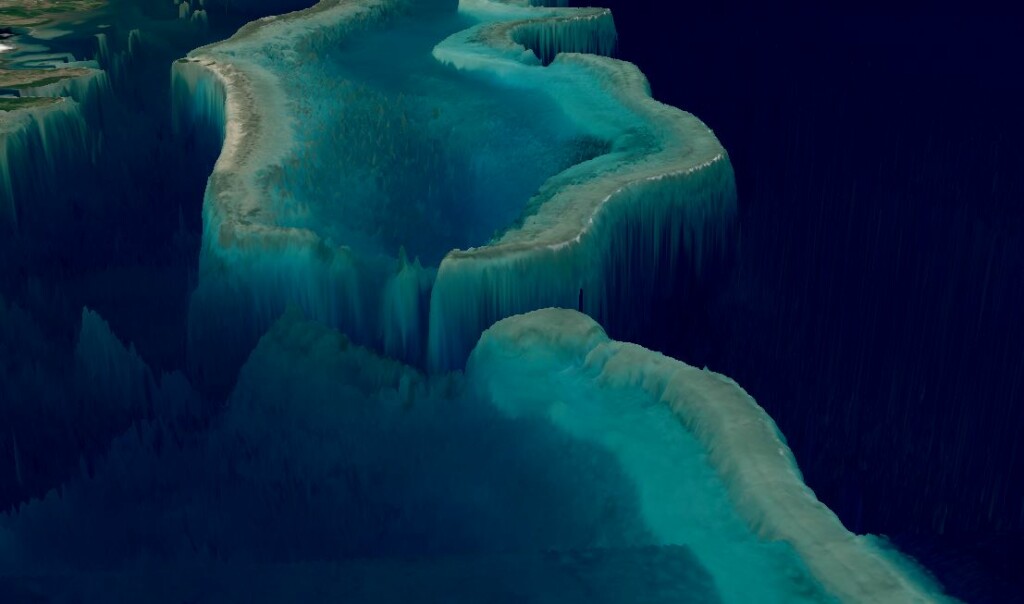
After the selection of scenes and processing – in her demonstration for Geo Week News, Reithmeier’s region was the Miami, Florida area, which she told us took about an hour of processing time – users can see the water depth results as well as visualize their data in a 3D viewer, allowing them to “have a look and check whether the morphology makes sense,” create profiles, and download the bathymetric data. In addition, SDB-Online also offers API access to their customers. In other words, allowing organizations to integrate the platform into their own solutions.
Who benefits from SDB-Online?
In addition to explaining some of the mechanics behind EOMAP’s physics-based SDB approach and how the online platform works, Reithmeier also discussed with Geo Week News some of the use cases for the platform. Among them was actually, perhaps counterintuitively, bathymetric surveyors. One of the big benefits of the SDB approach to bathymetry is the lack of need for surveying, but for those companies who are perhaps doing a more granular survey, or completing surveys for deeper waters, they often want to have more information about the area before the project. SDB-Online allows them to get that information without the expense of going out into the field to collect the data.
In addition to the surveyors, coastal engineers need this shallow-water data for their projects, but the multibeam surveys often create budgetary headaches and/or delay project timelines, problems that SDB-Online can help avoid. On the government side of things, coastal zone managers need reliable data reflecting changes along the coast and the seafloor, which SDB-Online aims to provide. Really, any project that is taking place along the coast can benefit from a tool like this with easy access to crucial bathymetric data, something that is only becoming more important as the effects of climate change further impact the entire planet.